It’s a sad fact of life for engineers designing cycling infrastructure that the sacred cow of on-street parking frequently frustrates good design. We see vociferous opposition from residents and businesses to the loss of car parking everywhere we turn – from Carlton Gore Rd to Franklin Rd to Westhaven Drive/Beaumont St to of course Queen St in Northcote. For some, the storage of private vehicles, often at no cost, is more important than moving people safely and efficiently along a roadway. We don’t yet live in enlightened times like our European cousins in the Netherlands and Denmark.

I’ve blogged before on the Northcote Safe Cycle Route, both the initial concept almost a year ago, quickly followed by a commentary when politicians started wading in.
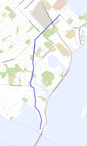
To recap a little, Auckland Transport (AT) came up with an excellent design for a near-continuous 5.2km cycle route between Takapuna North and the ferry terminal at Northcote Point as a component of the Auckland Cycle Network, which of course will also tie in superbly to the northern terminus of SkyPath. There were a few minor issues we highlighted back to AT, but overall we were delighted with both the concept and the design. But there was the vexed issue of loss of some Queen St parking in Northcote Point to make room for protected cycle lanes.
So how have AT handled this, particularly when heavyweight politicians like Jonathan Coleman MP and Councillor George Wood sided with the objections of some of the local residents?
Rather well, actually, particularly if your advocacy is tempered with pragmatism and budgeting realities.
AT could have carried on with their good design regardless, and we would have supported them, but it came with the risk of the entire project being canned or delayed due to political interference.
They could have realigned the road by narrowing the carriageway, shifting the kerbs/parking inwards and making for generous shared paths on both sides. But this would have cost a huge amount and blown the budget.
They could have done nothing, but this would have left the road feeling unsafe, particularly for children and those new to hopping on a bike.

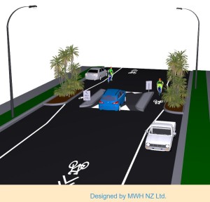
Or they could have slowed the traffic down by introducing one-way speed tables with cycle bypasses, and sharrows to indicate the road is a shared space. And this is what they’ve done – effective and economical. Read more on AT’s website. Sure it’s not as good as the initial design, but it’s an acceptable compromise given the low traffic volumes, and one which the locals should buy into as well. Not only is on-street parking mostly retained, the whole area from the Bridgeway to the Point will become a slow speed zone, making the area much more pleasant for residents, pedestrians and cyclists, and reinforcing the heritage nature of the area.
The other piece of good news about this project is that the Kaipatiki Local Board is right in behind it, funding is committed, and construction starts in mid-2016 to finish the following year. That should dovetail nicely with SkyPath!
But more than just a cycle route, this will be the catalyst for making the entire Northcote area more cycle friendly. Think more kids cycling to school and sports facilities, more commuters taking the ferry and SkyPath, better access and more patronage for the Bridgeway entertainment precinct, and more residential trips by bike to the shopping centres for a bit of #quaxing.
There’s one aspect of the southern Queen St design that could be further improved, though. While the physical elements will slow traffic down (especially the speedsters running late for the ferry), it needs to be reinforced by a 30kph speed restriction. 50kph is too fast to intentionally mix motorists and cyclists, particularly as there is no physical separation. According to AT, it’s just too hard. We’d encourage them to try a little harder, but it does raise the wider issue that Road Controlling Authorities such as AT shouldn’t have to jump through hoops to impose speed restrictions where they’re clearly warranted.

I’ve dwelt too much on the Queen St leg as this was the contentious part. Let’s not forget the other 4km where AT has done a great job with protected cycle lanes, good quality shared paths, and some special design for the Lake/Raleigh roundabout. It’s great that pedestrian crossings are part of the design – but technically cyclists have to dismount and push their bikes across, which is a bit of a nonsense. What we need (and something that’s common overseas, but our traffic markings don’t easily allow for) is a way of denoting that cyclists have right of way across a road.
So all up, good work AT. Let’s get on and build the Northcote Safe Cycle Route with some urgency, and enhance it from there. When combined with the shared path along Onewa Rd, SkyPath, SeaPath, the Akoranga Dr/Esmonde Rd shared path, the Green Route, the Lake Rd cycle lanes, plus neighbourhood initiatives, it will turn the lower North Shore into a mecca for bikes with good connectivity to the city. It just makes so much sense.
But we’d like to urge AT: next time the sacred cow of on-street parking wanders out onto the road, please keep your resolve when it comes to prioritising roadway space for active use!


