How’s this for an early Christmas present for people on the Shore? A major motorway project – the last link of the Western Ring Route – will now bring considerably improved connectivity for people on bikes and on foot, thanks to sustained and substantial work by the Bike Auckland team.
In particular, our North Shore infrastructure liaison Steve Southall was an absolute star at the recent Board of Inquiry (BOI) hearing into the SH1/SH18 Northern Corridor Improvements (NCI), whose decision is now complete.
Below, Steve explains Bike Auckland’s influence on the outcome, and how the path and the improvements we advocated for will transform the Albany Basin for people who want to hop on a bike to get around – plus, how crucial it is that Auckland Transport and Auckland Council come to the party with local links.
The Northern Corridor Improvement project, aka NCI, is something Bike Auckland has been engaged with for several years. We first submitted on the NCI (as Cycle Action Auckland) back in 2014, and we’ve continued to do so right up to appearing before the Board of Inquiry (BOI) in August 2017.
As advocates for everyday bike travel, we’ve always been concerned that big motorway projects (and this one is a four-year project worth $700m) will simply add to motor vehicle traffic, while cutting communities in half, particularly for those who want to walk or cycle.
And, while the NCI project included a shared path from the beginning – a happy legacy of the battle for Waterview is that it’s now standard practice for NZTA to thread paths for people alongside and across any new motorways – the question was always: would it be connected enough to be useful, and would those connections be safe enough to be attractive?
So we’re delighted that NZTA and the BOI itself have been communicative, pro-active and responsive to our requests to incorporate cycling facilities into the new motorway sections. Moreover, NZTA has also committed to working with Bike Auckland, Auckland Council and Auckland Transport to integrate bike improvements as best as possible into the surrounding greenways and street networks. These improvements have been formally documented in a side agreement signed between NZTA and Bike Auckland.
With its focus on walking, cycling and public transport, this really is a multi-modal transport project for which NZTA deservedly gets a thumbs-up.
And the good news doesn’t stop there! The Bike Auckland design team will continue to work with the NZTA Alliance partners and Auckland Transport as the concept design turns into construction drawings, to ensure we get the best outcome possible for people on bikes.
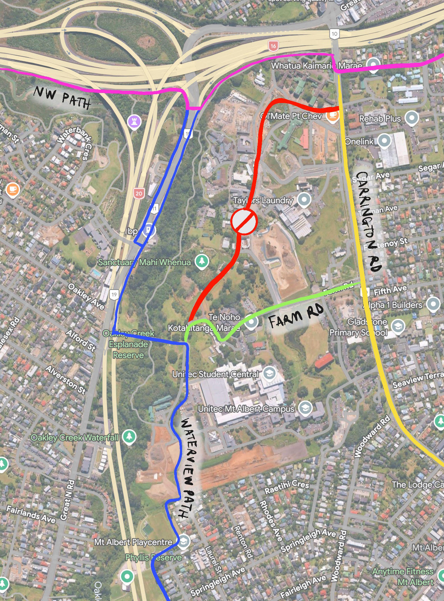
A new path for walking and biking
The NCI project will deliver 7km of a new 3m-wide cycleway (officially a Shared Use Path, or SUP). The path will run alongside the motorway from Oteha Valley Rd to Constellation Drive, then west to Albany Highway. It doesn’t have an official name yet, but think of it as the ‘Northern Cycleway’ – a northerly cousin mirroring the Northwestern Cycleway and the Eastern Shared Path from Glen Innes to the city. A new long-distance vital link, reaching into the heart of previously disconnected bike territory.
The new path also branches out west, along SH18. Logically, this section will one day connect to the Northwestern Cycleway at Westgate… so perhaps we could call that bit our East-West Link? (Too soon?)
Making it even better: turning wish-lists into wins
Cluster 1 – Oteha Valley Rd
Oteha Valley Rd is still a hostile environment for cyclists, and while the Oteha Valley Rd Corridor Management Plan promises good improvements for cyclists, implementation still seems to be way down AT’s priority list. But there are some bright spots around the northern terminus of the NCI shared path.
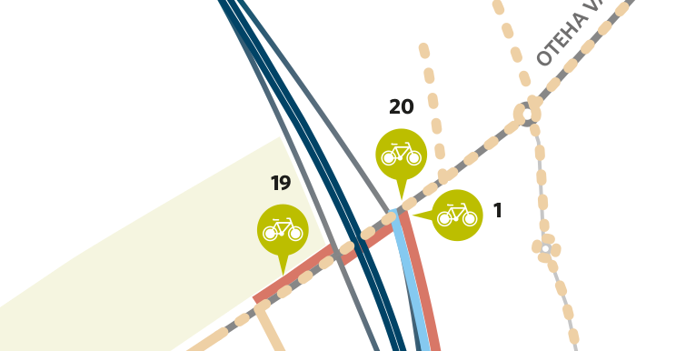
1 – Oteha Valley Rd
The shared path will connect to Oteha Valley Rd – so if you’re a brave on-road cyclist you’ll be able to enter and exit the path in both the easterly and westerly directions. Complementing this, the shared path from the northern section of Masons Rd to the south-east will also serve as a connector and entry to the motorway-side path.
19 – Oteha Valley Road connecting path
That nice off-road path to the north-west of the OVR interchange will be given a safe crossing to connect to the SUP.
20 – Crossing over Oteha Valley Road and eastern side path
Cyclists exiting the SUP and heading for the Bays will get a safe crossing; exactly where and how is yet to be determined.
Cluster 2 – McClymonts/Spencer
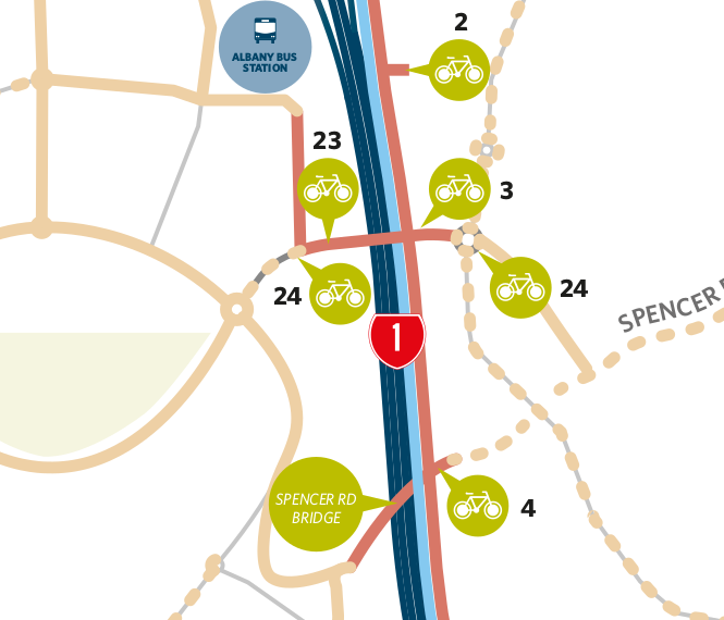
This one is key, due to the presence of the Albany Bus Station, the Westfield Albany shopping precinct, and Massey University to the west.
2 – Masons Road
A connection to the southern end of Masons Rd.
3 – McClymonts Road
Here we’ll have a good quality protected shared path on a new bridge crossing the motorway, including pedestrian and cyclist refuges.
23 – Elliot Rose path, McClymonts Road paths and extra SUP connection at McClymonts Road (opposite side)
This one provides the safe shared path to the Albany bus station. We know car parking is at a premium at the bus station, so making it easy for people to cycle and park their bike there is a no-brainer. This includes:
- Pedestrian and cycle refuges at Elliot Rose and McClymonts Road intersections
- Additional safety at the crossing points
24 – Spencer Road bridge connecting to Corinthian Drive
This win comes courtesy of Watercare, who needed to span a water pipe across the motorway. Why not co-operate with NZTA and AT, to create a shared path on top of it? An excellent idea, which should be in place by the end of 2018… and another East-West link for people powered transport!
Cluster 3 – Greville/Rosedale/Arrenway
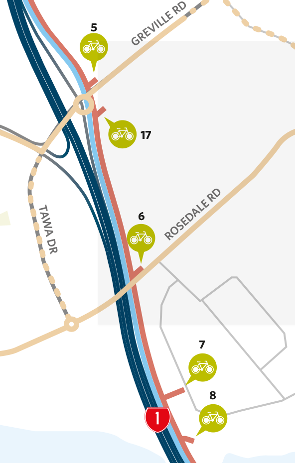
5 – Greville Road
A link to Greville Rd? Certainly useful, although it’s not the most pleasant spot on the Shore to ride a bike.
17 – Future link to Rosedale landfill reserve
The Rosedale landfill closed in 2009, and it’s still closed to the public. Methane, leachate, rubbish and subsidence means it’s probably quite a while until this link is utilised. If you do venture down there, don’t strike a match…
6 – Rosedale Road
What we’d love to see here is a new Bus Station. This is a separate initiative to the NCI and BOI process, and apparently there will be some news soon. Meanwhile, we need to ensure the SUP meshes cleanly with both eastbound and westbound cyclists on this very popular cycling route – one of the few transverse links on the Shore that actually has some semblance of cycling infrastructure. Widening the constriction under the motorway is a pipe dream, unless some serious money is put into the Rosedale Bus Station if/when it happens.
7 & 8 – Arrenway Drive – connections 1 & 2
On the eastern side of Arrenway and Apollo Drive we have the Millennium Institute (MISH) with 10,000 active members and 2,000 trips per day, and on its flank is Rangitoto College with a roll exceeding 3,000 students. This link will be be very popular with their north-west catchments: AT will need to address the local street network to ensure safe connectivity.
Cluster 4 – Constellation
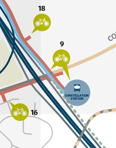
Here, the SUP heading south ends at the Constellation Bus Station. ‘Where is the section between Constellation and SeaPath’s northern terminus at the Akoranga Bus Station?’, we hear you ask. An excellent question, and one for which we don’t yet have an answer. We’ve asked NZTA to designate and secure this missing link, and we will continue to ask the question as we work through the design.
18 – Future link to Centorian Reserve
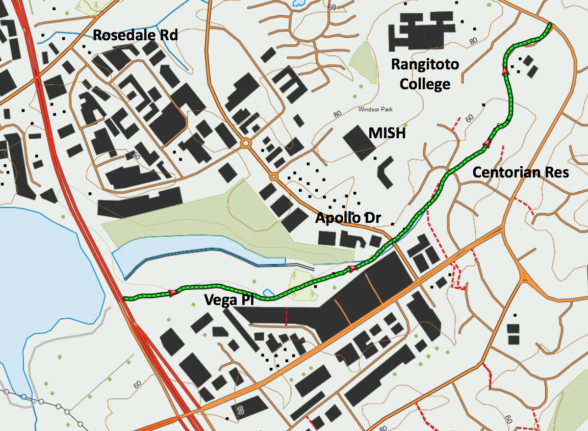
Now this one is exciting. Look at a street map, and all you see is a Watercare wasteland adjacent to one of their ponds. But have a closer look on Google Maps and you’ll see a green sliver running from Centorian Reserve west towards the motorway, across the top of Atlas Place. Switch to Satellite view and the link to the SUP becomes obvious and compelling. This is an undeveloped Auckland Council Greenways route, but we hope the NCI SUP gives it the push it needs. Not only would this greenway feed MISH and Rangitoto College from the south-west, it would also serve as an off-road transverse connector parallel to the relatively hostile Constellation Drive.
9 – Constellation Drive
The SUP goes right into the Bus Station from both the north and west. Constellation Drive itself? Not the most pleasant place for a cyclist to be, with the kerbside transit lanes either full of moving vehicles or parked cars. The Centorian Greenway link through to East Coast Rd will be a more welcoming option for all but the bravest on-road cyclists.
16 – Walkway to Cabello Place
Not a biggie in terms of catchment, but every little bit helps.
Cluster 5 – Paul Matthews/Caribbean
Our main concern with the SUP itself here is making sure cyclists are safely separated from motorists. Imagine you’re cycling east with your family from Paul Matthews Rd (symbol 11) across the bridge towards Caribbean Dr (symbol 10). Heading towards you is Boy Racer in his hotted up car, ostensibly at 50kph, but we all know the Tui ad that goes with that one. How safe will you feel, particularly on that curve as the car is starting to lose control on a wet road and is drifting towards you?
Our big push at the detailed design phase will be to maximise separation along this section (ie at least one metre), supplemented with physical barriers if at all possible. We know NZTA will have some challenges here, but they’ve committed to ‘best endeavours’.

10 – Caribbean Drive
There was always going to be a link to Caribbean Dr, but it was going to stop there…
21 – Eastern side path on Caribbean Drive
… until we and others lobbied for the path to at least extend up to the roundabout. We’d really like AT to take over here and extend cycling infrastructure south up the hill towards Sunset Rd. That would unlock the huge residential catchment in Unsworth Heights, allowing people to safely access the SUP and in particular the Constellation bus station.
15 – Walkway to Jumento Place
Like Cabello it’s a useful link.
11 – Paul Matthews Road
There’s a bit of detail to work through here so cyclists on Paul Matthews can safely enter and exit the SUP.
12 – Alexandra Creek and connection to existing underpass to Rook Reserve
We went through a bit of hand-wringing with this one, as we really wanted to see the Rook Reserve underpass widened and raised, because it sometimes floods in heavy rain. But it’s meant to, as it’s actually an overflow culvert. As NZTA pointed out it would be inordinately expensive ($5m+) and disruptive to SH18 to improve it, and with AT not prepared to come to the party on sharing the cost, the BOI cannot direct it be improved. So we’ll have to concede defeat on this one, and work on minor design improvements for access, alignment and safety issues.

Cluster 6 – Albany Highway/William Pickering
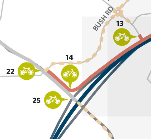
13 – William Pickering Drive
An important link to the north. We suggested a southern link to Bluebird Crescent, but the elevation changes are just too great to make this feasible.
14 – Albany Highway
A link to Albany Highway was always going to be a given, but it was going to stop there…
22 – Path along Albany Highway to Bush Road
…until we and others lobbied for improvements. AT’s Albany Highway North project has done an excellent job in providing good quality cycling infrastructure all the way south to Rothwell Ave, with an on-road cycle lane taking over to Bush Rd. Filling in the gap to the SUP was pretty obvious, and the BOI agreed. This will unlock more of Albany Highway’s cycling potential, as it lacks connectivity at the moment.
25 – Safety measures at SH18/Albany Highway intersection
Here we look wistfully at AT’s plans for the Albany Highway South project, replicating the quality work already done for Albany Highway North through to Sunset Rd. Sadly, Albany Highway South is still on hold, including addressing the appalling Albany Highway/Upper Harbour Drive intersection.
If you ever want to scare yourself witless on a bike, try turning right from Upper Harbour Drive into the 70kph zone with cars bullying you from behind while you’re trying to merge into high speed traffic on your left. It’s not pretty (as immortalized in this terrifying clip by our friends at Transportblog/ Greater Auckland).
We really hope the SUP will be the impetus AT needs to address this appalling intersection and rejuvenate Albany Highway South. NZTA have committed to working with AT to investigate the feasibility of bringing this project forward. Fingers crossed.
Meanwhile, we at least get some safety improvements so on-road cyclists can safely enter and exit the SUP at the Albany Highway intersection.
So in summary, there’s a lot to like with what NZTA are doing…
…but NZTA is only half the equation.
The Albany Basin has huge potential for more people to get around on bikes with its large residential catchment, light industry, transport hubs, shopping centres, schools, universities and recreational facilities. That’s why Auckland Transport really needs to step up here with the connecting links – and likewise, Auckland Council, with greenway connections – so the new SUP spine can yield its greatest benefits for all the people who live within walking and biking range.
We’ll continue to keep you posted as we work with the Alliance team on the detail, as that’s where the devil will be lurking.