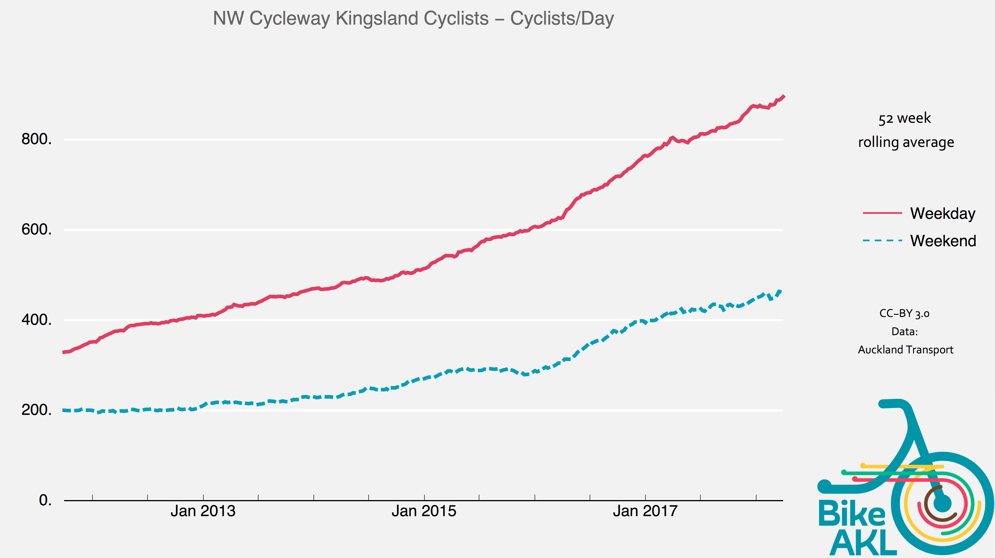
Running alongside SH16, the Northwestern Cycleway is not only the key bike path from the western suburbs into the CBD, it’s also a crucial local connection to and between Kingsland, Eden Terrace, and Arch Hill. And it’s booming – daily bike traffic has tripled in less than five years, with a daily average of close to 1000 trips registered by the automatic bike counter near Bond St (and 1500 on the last Thursday in February!).
It’s a huge success story – with a major pinch point: the section between St Lukes Rd and Newton Rd. Built in the early 2000s as a shared path for bikes and pedestrians, the width and design here simply haven’t been able to accommodate the growth in both walking and cycling.
Add in the fact that this is also a key school route for many children from Newton Central primary school, both on bikes and in ‘walking school buses’. With a roll of approximately 300, Newton Central is expected to grow strongly over the coming decade as the area intensifies further. Sharing the path safely and courteously is already a challenge, especially at the ‘bottleneck’ section around the Waima Street-Haslett Street overbridge over SH16.
That’s why Bike Auckland and Newton Central School are jointly proposing an upgrade of the path, starting with the ‘bottleneck’. The upgrade would add a dedicated footpath for 1km, separated from the cycleway by a kerb; and upgrades near the motorway footbridge, including a raised zebra for safely crossing the bikeway.
The background
When the NW Cycleway was built through Kingsland and Eden Terrace in the early 2000s, no attempt was made to allow for a separate footpath. This was partly due to limited funding and partly to official scepticism about user numbers: it was thought unlikely the ‘shared path’ would become so busy that sharing it would be a problem.
Famous last words. In reality, there’s been a huge growth in use by pedestrians and by people on bikes. Within the last 5 years, boosted by improvements all along the path and better connections into the city, weekday cycling numbers have more than doubled.
At the same time, there are more and more pedestrians on the path – people walking into the city, jogging, walking dogs, visiting neighbours, walking to school – leading to unpleasantly tight conditions here, especially at rush hour.

Transport engineering guidelines recommend shared paths should not be used where there are more than 100 pedestrian movements per hour. While there’s no official walking counter, our sense is that this level has already been reached or exceeded – especially in the section between Kingsland and Newton. This is the main school catchment area, and also the area where most pedestrians walking into the City Centre join the path.
Both pedestrian and rider numbers will continue to grow in coming years, thanks to:
- Walkable commutes are increasingly attractive to health-conscious Aucklanders looking to get out of traffic.
- E-bikes are making riding more attractive and accessible to people formerly discouraged by hills.
- The Waterview Path (opened October 2017) will bring more riders from as far away as Avondale/New Lynn riding to the City Centre
- The Ian McKinnon Drive cycleway project (currently underway) will create a new flatter path between Takau Street/Suffolk Reserve and Upper Queen Street, leading to more bikes and pedestrians through this section.
- More housing in the Kingsland and Newton areas means that even without these new connections, use of walkways and cycleways will keep rising.
The issue
Rising bike and pedestrian traffic on a busy (and sub-standard) shared path like this one tends to have a compounding effect:
- Walking becomes less pleasant and safe, with pedestrians constantly looking over their shoulders and wary of riders passing too closely
- Riding becomes less pleasant, with riders dodging pedestrians and less able to maintain a steady pace
- While actual bike vs pedestrian injuries are statistically quite rare, even ‘close calls’ can be enough to put people off walking, especially older people (as is true of cycling and cars)
- Parental concern about letting children walk or cycle amongst busier bike traffic, especially alone
- Traveling side by side – social riding and walking – becomes hard, making the path less useful for parents with children, or people simply wanting to enjoy the journey with company and chat.
Courteous and safe behaviour helps somewhat, but even when the vast majority of pedestrians and people on bikes behave thoughtfully, these issues will persist. Bikes – even without electric assist – have normal gentle travel speeds of 15-20 kph, which is already faster than suitable around pedestrians, and long-distance commuters often set a more cracking pace.

It’s clear that the current ‘shared path’ design is not sufficient anymore and the path should be improved, beginning with the narrow and congested Newton section.
The solution
The key solution is simple and follows best practice overseas, which is also increasingly used here: give both walkers and bikers dedicated space. Pedestrians shouldn’t have to dodge bicycles, just as they should not have to dodge cars. And people on bikes should be able to travel courteously at normal bike speeds.
We propose the Northwestern Path be upgraded in sections, starting with the areas shown in Figure 3 below:
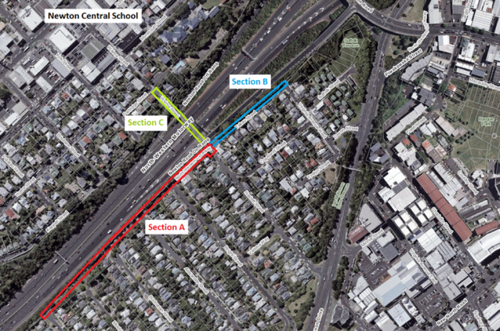
- Section A: the NW path between Richbourne St and the Haslett St end of the overbridge: approximately 350m long. This has the highest volumes of walkers and riders, because many coming from the south then continue via the overbridge to cross towards the school or, in the case of riders, towards Ponsonby Road and K Road. It’s also a great starting section for the upgrade, because there is plenty of width available.
- Section B: Takau Street between Haslett St end of the overbridge and Virginia Ave West: approximately 150m long. This section currently has no cycleway at all, and only a very narrow and often blocked footpath on the southern side, obliging all users to walk and cycle on the street. It’s more constrained in width than Section A, and so more challenging to fix.
- Section C: The Waima St-Haslett St overbridge, including the short section of path on the northern end up to Partridge Street: approximately 150m long. Concerns here include the low railings and the narrowness of the bridge; and riders coming down onto the bridge too fast, particularly from Great North Road down the steep Waima Street approach.
Proposed improvements – Section A
A new footpath can be built by cutting back the bushes on the motorway side slightly, and building out over the open stormwater drain (piped instead, if needed) as per Figure 4.
The footpath will provide a much safer and more pleasant walking environment on the steep section up towards the Haslett St overbridge, where downhill riders coming south can tend to pick up speed.
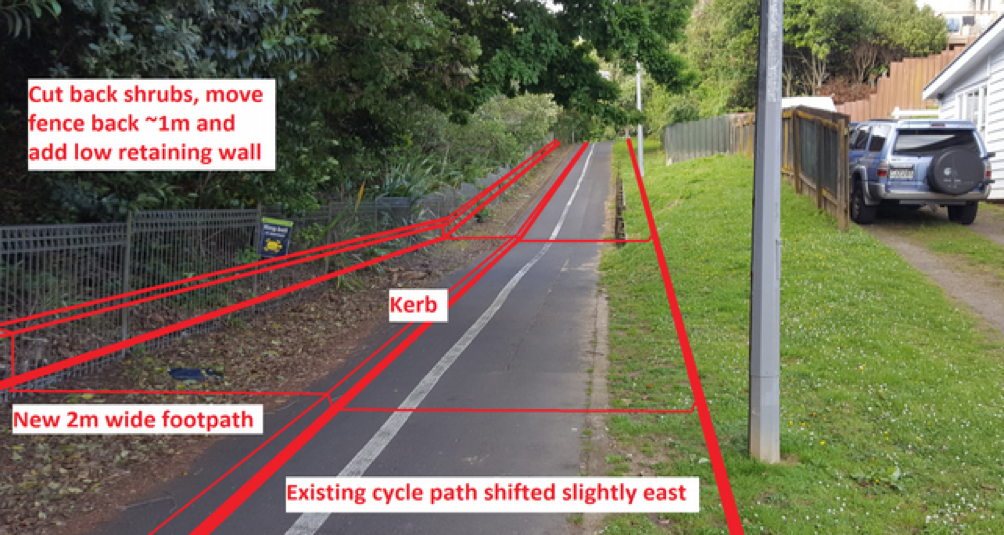
The existing cycle path is retained, but slightly shifted south (by 0.5-1.0m) to help make space for the new footpath. This can be done without removing the connecting single-lane road between Bright St and Alexander Street or the driveway to the end of Buchanan Street. The upgrade would only use land already owned by Council or Crown, as shown in Figure 5.

At the top of the ramped section, under the motorway overbridge, we propose a zebra crossing on a ‘raised table’ (ramped either side of the crossing to slow riders down). This will let pedestrians from the footpath cross over the cycleway more safely, as per Figure 6.
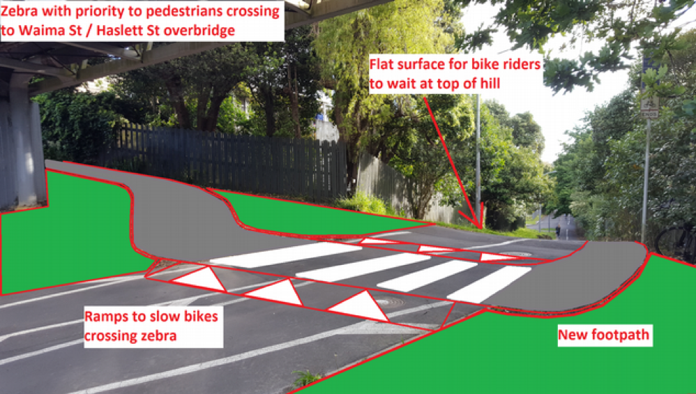
The changes proposed for Section A could be implemented quickly and without noteworthy downsides for any stakeholders, including nearby residents. This would significantly improve conditions for pedestrians and cyclists in a key section, while setting a best-practice example.
Proposed improvements – Section B
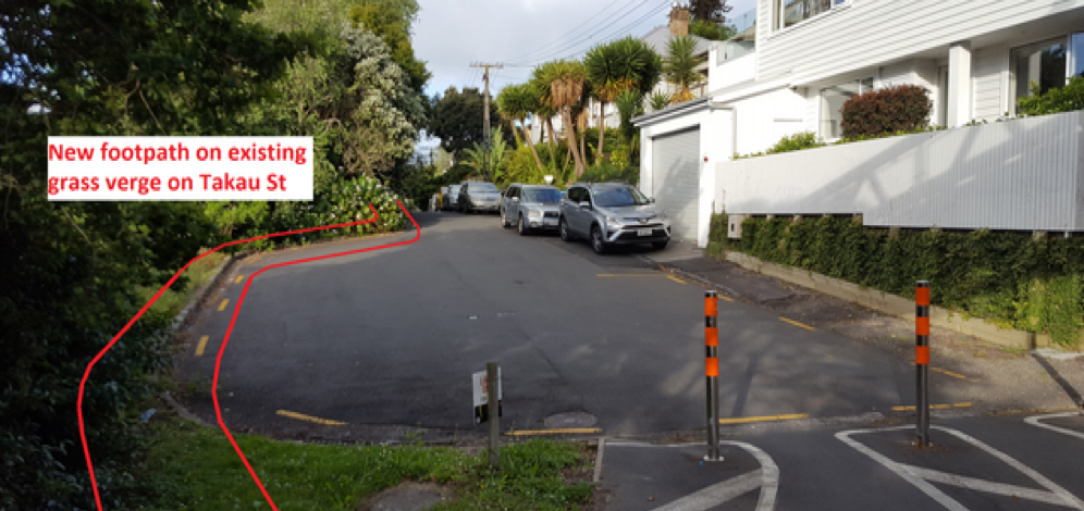
Improvements in this section are a little trickier, as Takau Street currently has no pedestrian or cycle facilities, barring the narrow footpath which is blocked by cars, rubbish bins and power poles.
Unless significant retaining walls are added on the motorway side (and some trees removed), this section probably can’t accommodate the roughly 5m width needed to create a separated path.
However, as an easier interim improvement, a footpath could be provided along the existing grass verge, leaving cyclists on-road for the time being. This would still be an advantage for both people on bikes and foot: pedestrians get a dedicated space, riders have more space on-road separate from pedestrians (if not yet from cars, but it’s a very quiet street). This is shown indicatively in Figure 7.
Proposed improvements – Section C
Improvements to the Waima Street – Haslett Street overbridge depend on long term projects in the area – in particular, the proposed light rail line along SH16, which may require bridge modifications some time in the next 10 years. Major improvements – such as bridge widening – are unlikely in the interim, but on the positive side, when light rail happens, improvements may be much more substantial.
In the meantime, we suggest addressing one key issue: riders coming down the steep hills (particularly on Waima Street) and entering the relatively narrow bridge at speeds that are too high for safety. We suggest that this concern could be reduced by:
- Adding a slight chicane to the path between Partridge St and the bridge. NOTE: this would not be a set of fenced chicanes, which are a dangerous crash risk themselves. Instead, we recommend an S-curve in the path created by landscaping – low shrubs or grass – which can be ridded through without dismounting at appropriate speeds (say 10-20 kph) but cannot be travelled through at higher speeds.
- Alternatively, or in addition, adding a raised table for bikes, similar to that shown in Figure 6.
The who and the how
The upgrade is a relatively inexpensive project that fits well with the aims and strategies of Auckland Council and the new Government around transport and schools, and falls under the ambit of both council and government (via Auckland Transport and the New Zealand Transport Agency, NZTA).
AT operates the Northwestern Cycleway and, with NZTA, would be the entity to undertake the upgrade (unless it’s deemed more suitable for NZTA to lead the project – NZTA operates SH16, and constructed several recent upgrades of the path.)
The work could be completed in several stages, and falls fully within Council and NZTA land. Note: most of the project is located in the Albert-Eden Local Board area, though it would also benefit people in the Waitemata Local Board area, where Newton Central School is located.
Next steps
Bike Auckland took this proposal to Newton Central late last year, and it’s been endorsed by the principal Riki Teteina and the Board of Trustees. We’ve since conveyed this proposal to Auckland Transport and they’ve agreed it merits further investigation.
Funding is the next issue: while not very extensive as transport projects go, it may still be too costly for ‘business as usual’ improvements via AT’s minor safety or walking and cycling programmes.
Fortunately, the new government has indicated a much stronger focus in the 2018 transport budget for walking, cycling and safety – and is also explicitly seeking to encourage more active travel to schools. Mayor Phil Goff has also stated his expectation that AT will support safe travel to school on foot and by bike more strongly.
As such, Bike Auckland and Newton Central School strongly ask that this upgrade be investigated ASAP, as a best-practice project that ticks all the boxes.
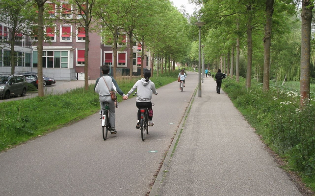
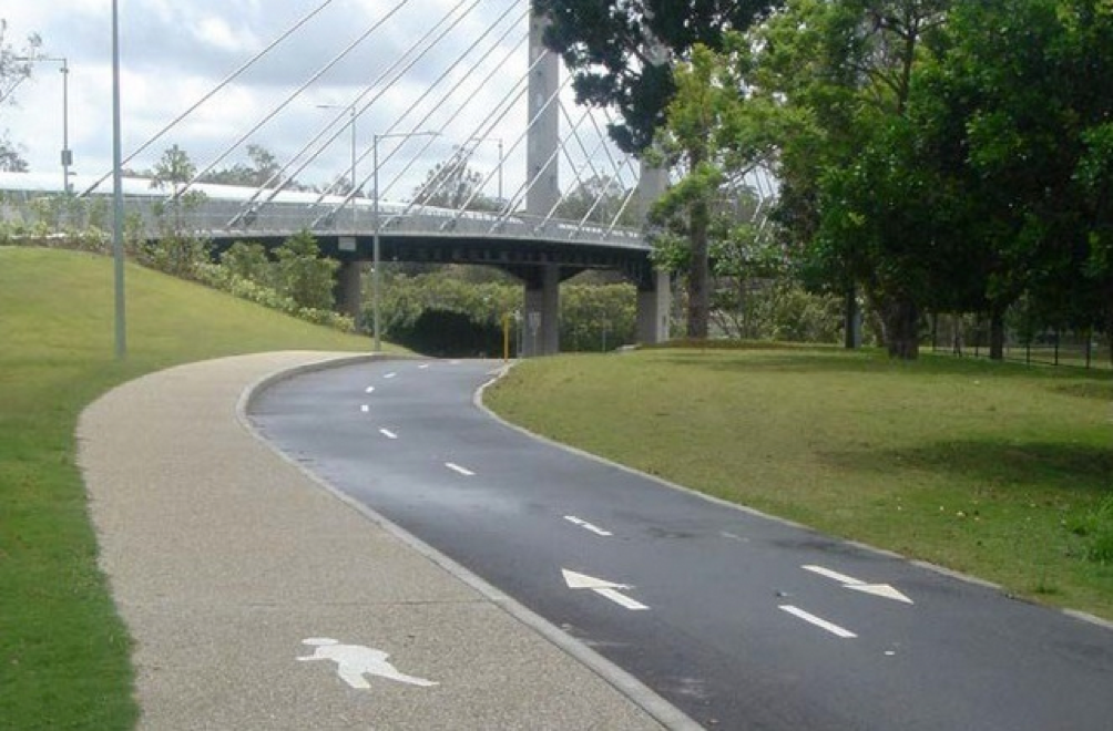
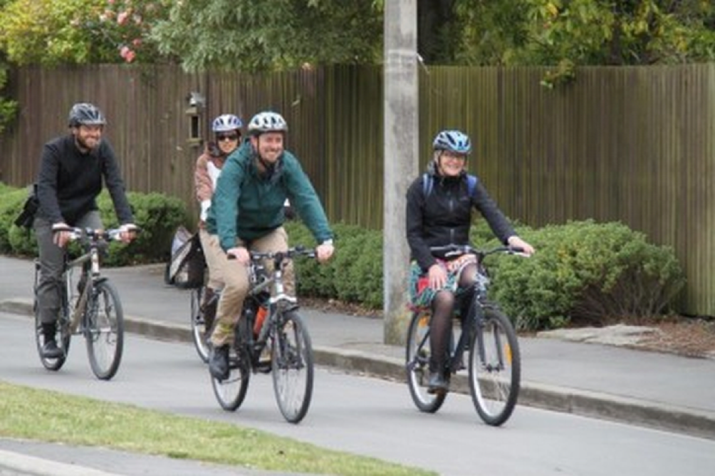
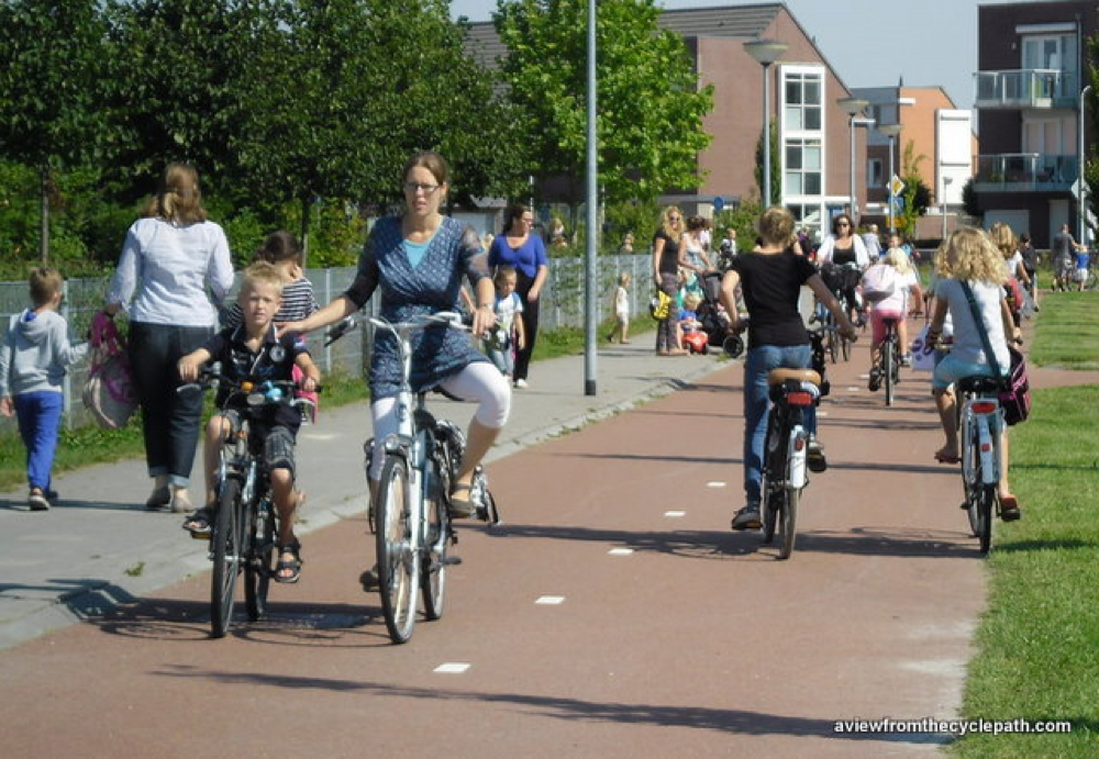
More examples of separated paths