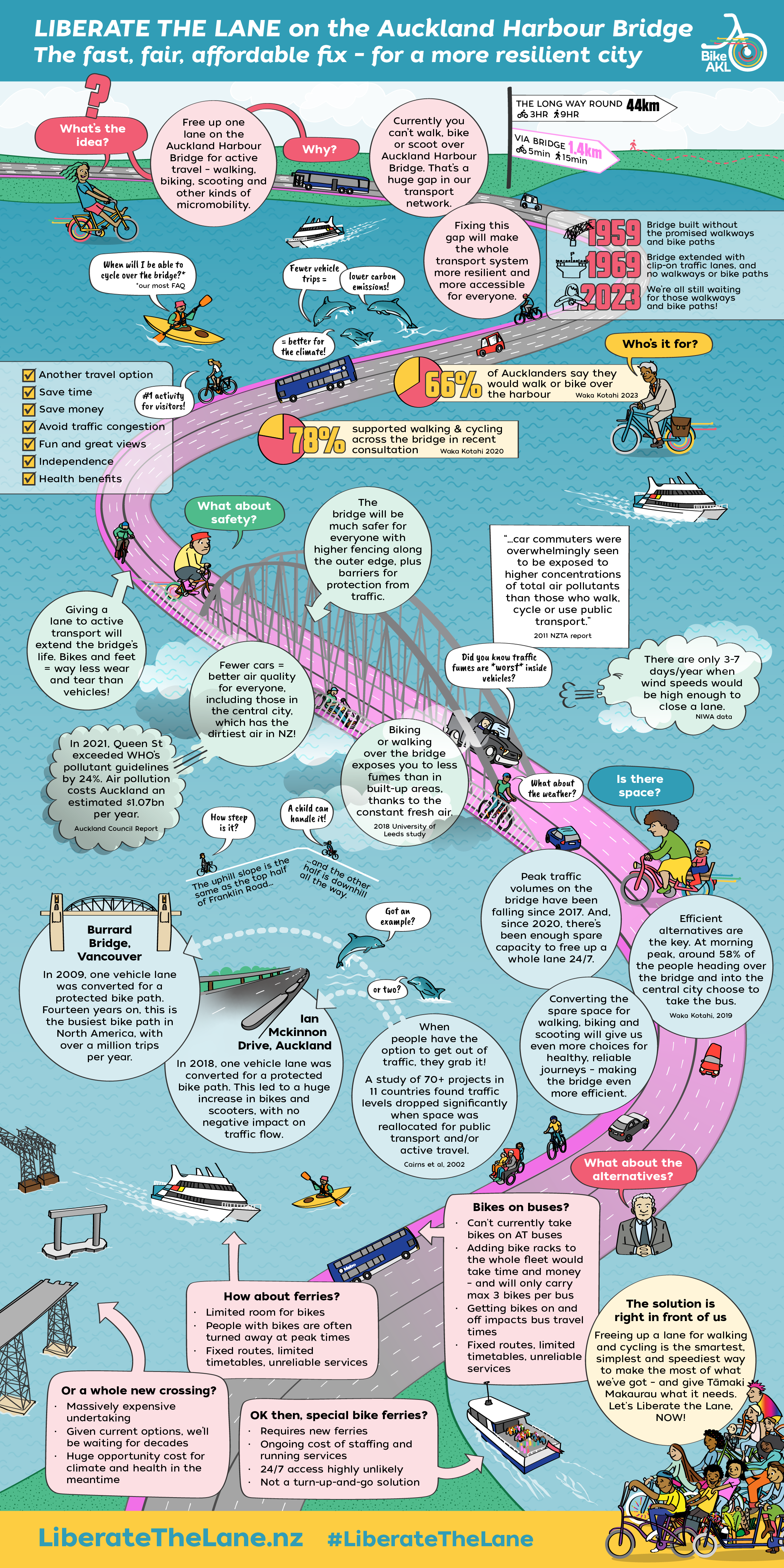
Bike Auckland commissioned SmartSense Ltd to investigate the feasibility of liberating a lane on the Auckland Harbour Bridge for active mobility – walking, cycling and other personal mobility options. Using Waka Kotahi NZTA data, Richard from SmartSense has confirmed that Liberating the Lane for walking and wheeling is absolutely safe, viable, and can be done now! However, Waka Kotahi maintains that it will not Liberate the Lane. The urgent completion of our active modes network is crucial for emissions reduction, accessibility, and affordable transport choice. Waka Kotahi has a responsibility to resolve this glaring gap in the heart of our transport system now. Bike Auckland will keep advocating for access for walking, cycling, and wheeling across the harbour so that Tāmaki Makaurau Auckland can become the climate friendly, world-class city it wants to be.
Our next step is to build public pressure – keep a lookout for Liberate the Lane messaging on buses in the CBD and North Shore! We’re in campaign mode and we ask you to join us.
Continue reading to find out more about our vision for a more accessible and inclusive Waitematā Harbour.
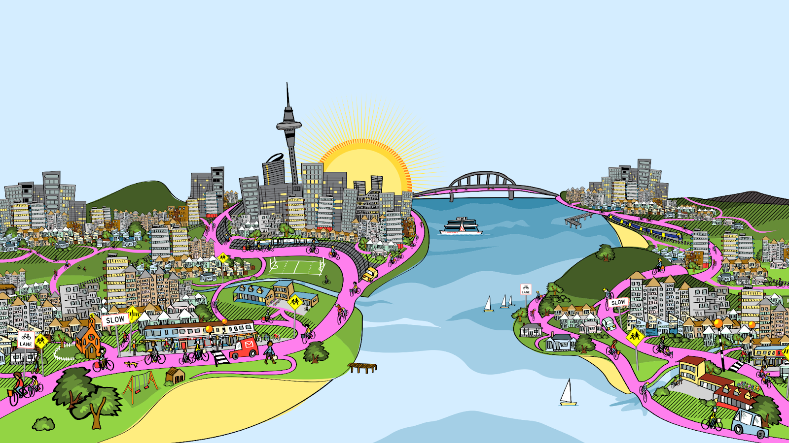
A Tāmaki Makaurau Auckland for Everybody
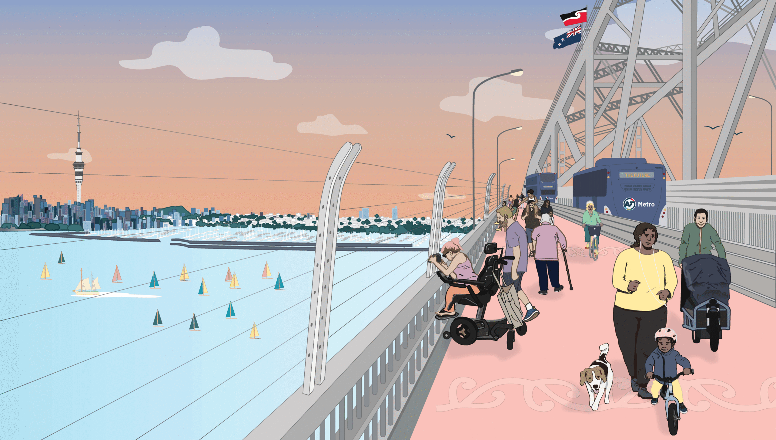
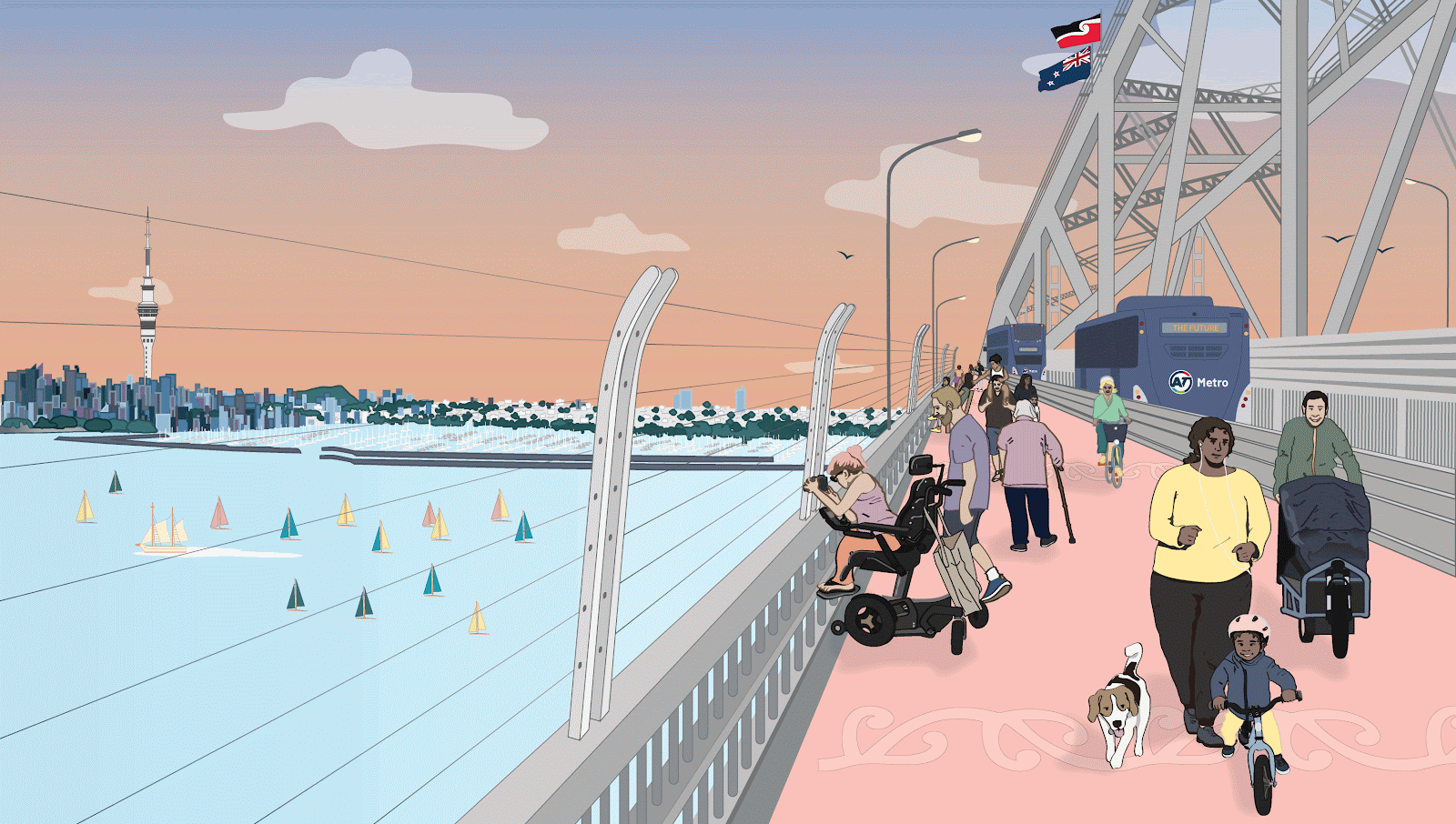
It’s 2024, and the Auckland Harbour Bridge is finally open and available to all modes of everyday transport.
Using a dedicated lane protected from traffic, people walk, scoot, and cycle across the Waitematā Harbour, saving time and money, and breathing in the stunning view of the city across the water.
Tourists stop and take photos, commuters in suits cycle by, and families are out walking, their kids riding scooters, going on a joyful adventure together. Bus passengers wave at them as they pass.
Everyone can travel between the City Centre and the North Shore in the way that they want to, and (of course) some people are still driving across in the free flowing traffic.
This is the Tāmaki Makaurau Auckland we dream of.
We can get there by reallocating one lane on the Auckland Harbour Bridge for people powered transport.
This can be done quickly and affordably, with little to no impact on traffic flows.
✔ It will empower people to choose climate-friendly travel
✔ It will give more transport choice to people who don’t drive
✔ It will reduce the cost of travel for many
✔ It will create a more resilient transport system
✔ It will make more efficient use of our existing transport system
And, most importantly, it will be safe.
We know it’s possible.
So, what’s the hold up?
Waka Kotahi (NZTA) has the power to create a safe, equitable, climate friendly connection for people to walk and wheel across the Harbour Bridge now.
We call on Waka Kotahi to free up one lane on the Auckland Harbour Bridge for walking and cycling, for a more resilient and connected transport network for people in Tāmaki Makaurau.

What exactly are we asking for?
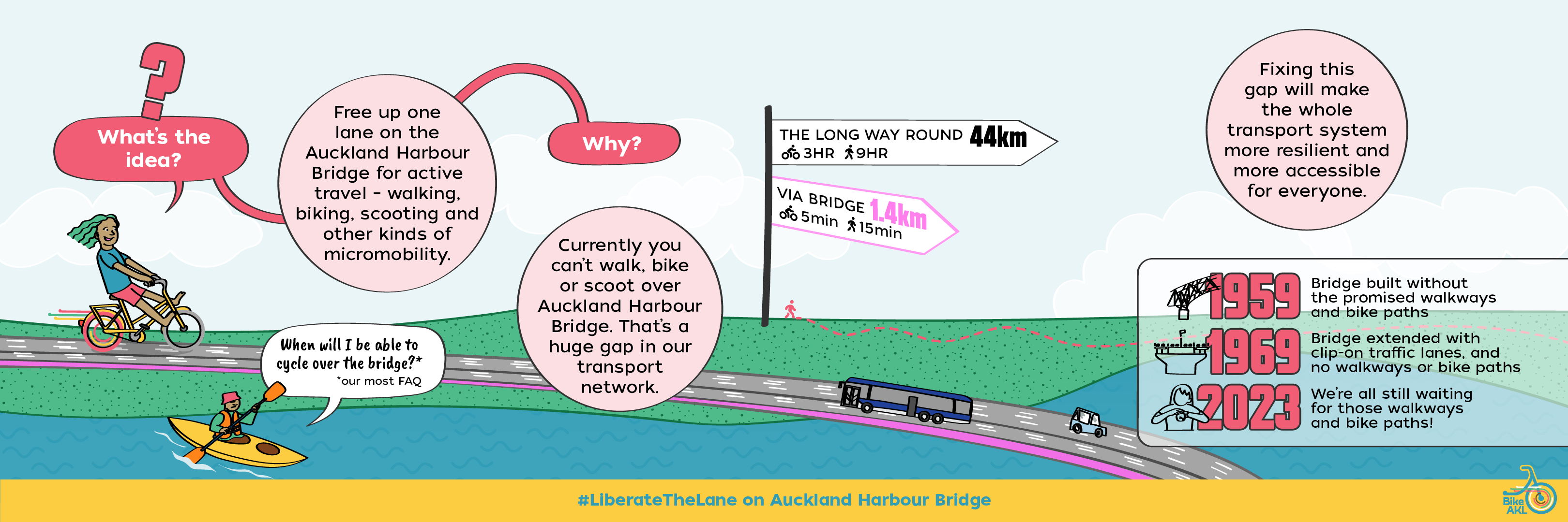
We’re calling for one lane on the Auckland Harbour Bridge to be permanently motor traffic-free, enabling people to walk and wheel across Te Waitematā between the North Shore and the CBD.
Why?
At the moment the only way to walk, scooter, or cycle from the North Shore to the CBD (and vice versa) is over 40 km travelling all the way around the harbour via Hobsonville Point! This takes roughly three hours on a bike, and at least eight hours on foot. It’s not a serious option for everyday transport. Especially when the Harbour Bridge is right there.
But to cross the Auckland Harbour Bridge we currently must be in a car, bus, truck or on a motorbike. A child can see it, and visitors to our city remark on it: this is a glaring gap in the heart of our transport system and a huge barrier to access and equity (especially for the more than 28% of Aucklanders* who don’t drive).
Tāmaki Makaurau may well be the last city in the world built around the water where people who want to walk, ride or roll from one shore to the other are told: You shall not pass!
Dedicating one lane to walking and cycling (and skating, and scootering…) on the Harbour Bridge will fix this injustice – and provide a golden opportunity to tackle a bunch of other urgent problems we face, from congestion to pollution, from accessibility to resilience.
Why the Auckland Harbour Bridge?
Because it’s there! It already exists, and it’s the shortest route from A to B. No wonder the question we’re most often asked in our advocacy for a more bikeable city is: ‘When can we bike over the bridge?’
From Westhaven on the city side, you can see Northcote a few tantalising minutes away on the North Shore. It’s just over one kilometre. That’s a ten-to-fifteen minute walk, and even less on a bike or scooter!
Converting one lane for walking and cycling is the fastest, fairest, most affordable way to bridge this gap between the North Shore and the rest of the city. It’s also the smartest way to get full value out of this vital link in our national transport system.
Why now?
It’s time. It’s beyond time.
For decades, Aucklanders have watched, waited, and despaired as plan after plan for walking and cycling across Te Waitematā has been proposed, picked apart, and then cancelled. It’s already been over half a century of debates and delays. Generations of wasted potential for easy, healthy journeys, and lost opportunity to get Aucklanders out of traffic and reduce our emissions.
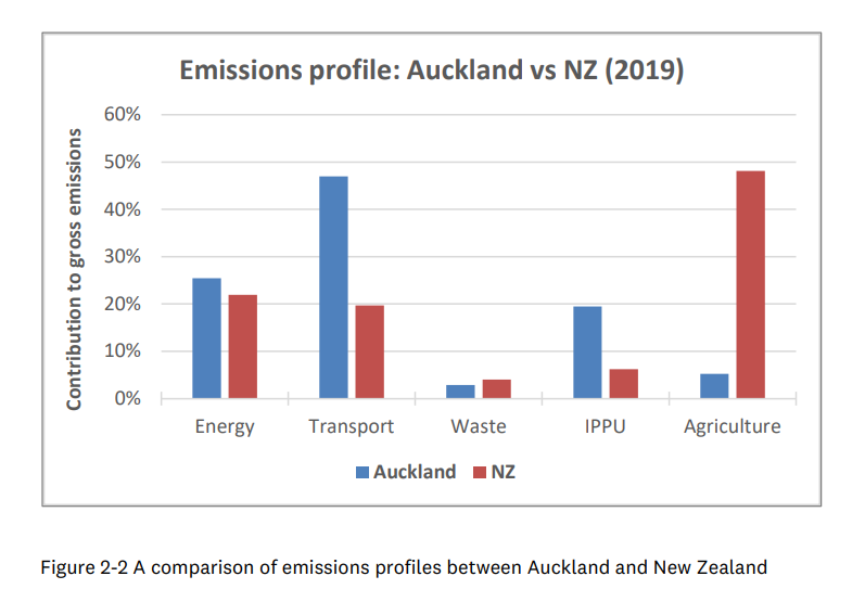
There’s growing urgency for climate action – and 45% of Auckland’s emissions are from transport, with 79.9% of that from cars! We have a great opportunity to reduce emissions by empowering people to choose climate friendly transport like walking and cycling. Because of this, the Climate Commission’s recommentations include completing cycle networks in main cities by 2030; and the Harbour Bridge is a big missing gap in our network!
We also need more transport choices for greater resilience of our network. And, we’re also in a cost of living crisis! Giving Aucklanders more choice for how they travel will enable people to be able to let go of the high cost of owning and maintaining a car.
Public demand continues to grow – as consistently shown by consultations carried out by Waka Kotahi.
“Most of the feedback affirms public calls to ‘just get on with building it’”
Waka Kotahi, 2020
- 1959: Harbour Bridge built without the promised walkways and cycleways
- 1979: Students took a protest ride over the bridge and the Northcote Resident’s Association wrote to the Times in support of walking and cycling access
- 2004: A petition to parliament for walking and cycling access across the Harbour Bridge gained 6,700 signatures
- 2009: The Get Across campaign gathered 12,000 supporters, and a rally across the bridge attracted 5000 protestors
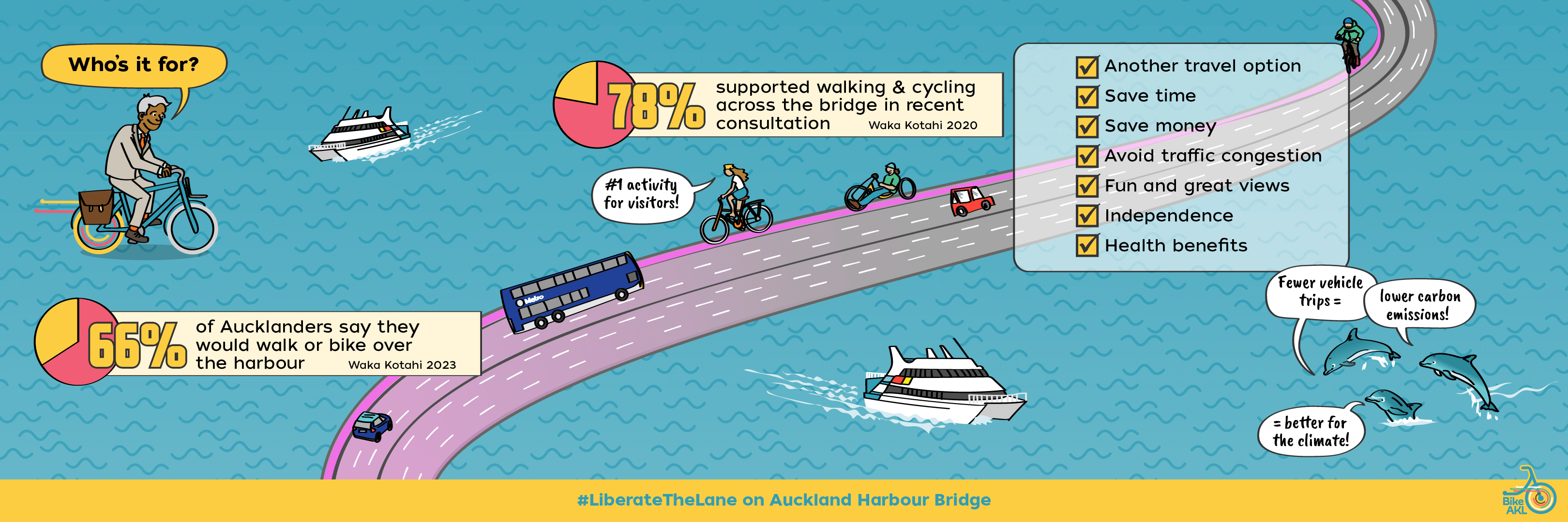
- 2020: 78% found to be in favour of a walking and cycling connection across the harbour (Waka Kotahi 2020)
- 2021: Bike Auckland leads a Liberate the Lane rally with approximately 2500 people in attendance
- 2023: Release of new crossing designs, which would take 10 – 20 years to be completed. Meanwhile, surveys show that 66% would walk or bike across the harbour* (Waka Kotahi 2023)
“There was also strong support for cycling infrastructure sooner, rather than later, with comments suggesting a cycle lane on the current bridge”
Waka Kotahi, 2023
Frequently Asked Questions
Who would use a shared path on the bridge?
We’re asking for the same kind of access currently enjoyed by those who go by car: 24/7, seven days a week, weather permitting. That means the lane would be used by everyone and anyone who wants to use it.
From daily commuters – walking, running, scooting or cycling – to students and shift-workers, tourists and visitors, leisure riders and runners, families on outings, and businesses that use bicycles for delivery and transport.
Data from the 2018 Census suggests there are as many as 80,000 trips each day back and forth across the harbour to locations within biking distance.
5 – 7km is an easy distance for most people to ride a bike, with e-bikes (and e-scooters) expanding this range to 10 – 15km. Some people will happily cycle even further! Research shows that many Aucklanders already own a bike, and sales of e-bikes and personal e-scooters continue to rise.

The potential is obvious. According to a recent survey by Waka Kotahi (January 2023), almost every Aucklander has travelled over the bridge in the last year, and 66% say they would walk or cycle across the harbour, if it were possible.
Moreover, this is an equity issue. More than 28% of Aucklanders* don’t or can’t drive, and at least 60% of Aucklanders say they would ride a bike if it were safe.
Will the bridge wobble when people walk, scoot or cycle on it?
During ordinary use the bridge will be secure and stable when people are crossing by bike, scooter or foot. The bridge is strong and will last for a very long time; it will not be adversely impacted by opening a lane for people-powered transport – it might even benefit from the overall lighter load as people are significantly lighter than cars!
The details:
- The two outer most lanes on both sides of the bridge are “clip ons” – they were attached to the side of the bridge in September 1969
- When a substantial amount of people (eg. over 1600) are all walking together on both lanes of a single clip-on, it will move, which can feel alarming
- Waka Kotahi found a solution to the issue in 2010; dampers can be used to stop the movement from occurring
- The clip-ons movement can cause a space between the bridge and the clip-on to open and close, which could cause injury if someone got caught in it
- We are advocating for the single outer-most lane of the Eastern clip-on to become a shared path. This would include a barrier between the path and motor traffic – which would also prevent people from being anywhere near where the clip-on and the rest of the bridge meet (i.e. the area that could cause injury if the movement was occurring)
- Running, cycling, scooting and skating do not cause the bridge to have this movement. It is specifically walking that causes the movement of the clip-on, for science reasons (resonance!)
- It is predicted that a shared path over the Harbour Bridge would have a peak usage of 500 people walking on it all at once (and significantly more people on bikes!). This is much fewer walkers than would cause it to move
- However, if the bridge clip on was used for a large protest march it could cause an issue, so Waka Kotahi should still put dampers in place to make sure it is safe during those instances
- Additionally, moving vehicles off one lane and replacing them with people on lightweight bikes means the bridge will see less wear and tear over all. While Waka Kotahi have given us no reason to believe the bridge clip-ons will need replacing any time soon, reallocating a lane to active transport should extend the bridge’s life
How do we know this? We commissioned Richard Young, an independent Traffic and Civil engineer (of Smartsense Ltd.), to investigate reallocating a lane on the Harbour Bridge for walking and cycling. Using Waka Kotahi data he has confirmed that Liberating the Lane for walking and cycling is absolutely still safe, viable, and can be done now! You can read more about his findings here.
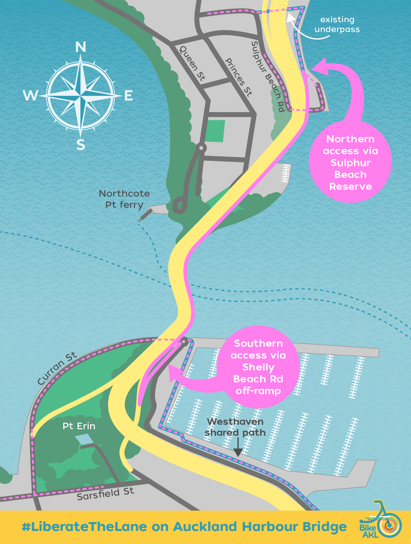
How would people access the liberated lane?
The Easternmost lane should be liberated as it is the most sheltered from the wind (predominantly Westerlies). On the City side, the lane would link to the existing paths and greenways in Westhaven. On the North Shore side, it would connect into the Northern Pathway which is being completed beside SH1.
Originally designed to connect with the now-scrapped Skypath crossing, the Northern Pathway is already open from Albany to Constellation station, with a plan to extend to Akoranga. It wouldn’t take much to continue that connection to the Harbour Bridge itself.
This would link the North Shore directly into the isthmus walking and cycling networks, and vice versa.
This map shows potential options for accessing and exiting the liberated lane.
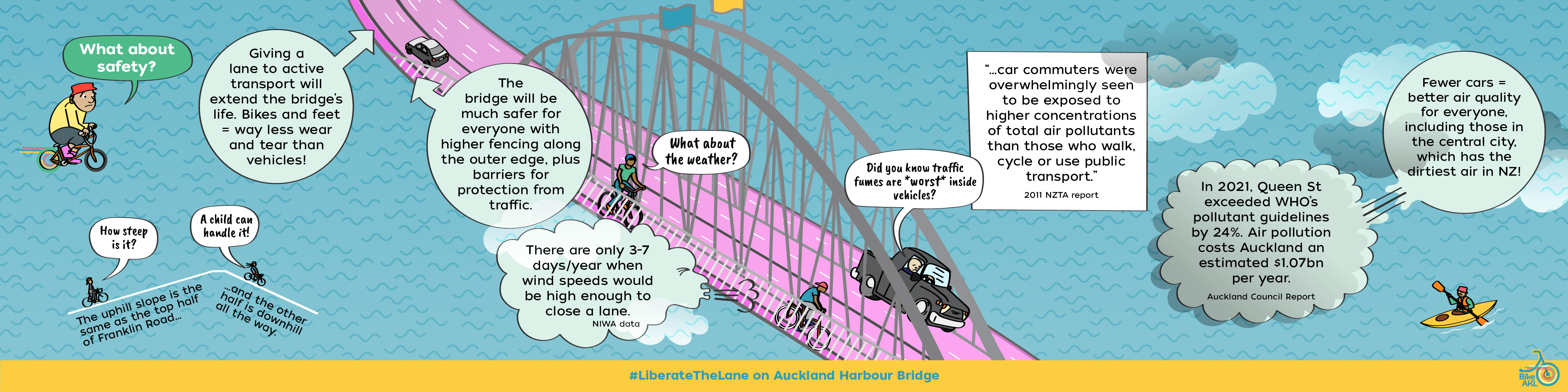
What about safety?
Any design for a shared path across the Harbour Bridge will necessarily include solid barriers to protect people from traffic and an anti-climb barrier along the outer edge to keep everyone safe. Cities all over the world have walking and cycling paths designed in this way, which have worked safely for decades.
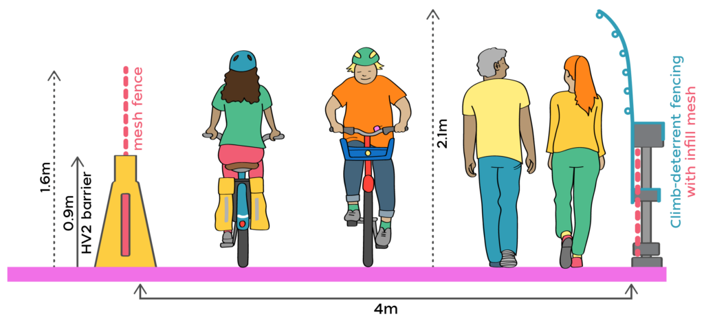
Bike Auckland comissioned SmartSense Ltd to investigate the feasibility of reallocating a lane on the Harbour Bridge towards walking and cycling and the resulting report showed it absolutelly can be done safely. SmartSense Ltd has created the following design solution:
- A shared path for active modes on the most easterly clip-on lane. The east side provides for better protection from wind (predominantly Westerlies), easy access on and off the bridge, and stunning views of the harbour and city
- Shared path has 4metre width which is within the Austroads guidance for gradient (5%) and width with the expected usage
- The use of free-standing HV2 Steel/Concrete composite barriers with mesh fence between the shared path and the motor traffic. This is a relatively lightweight barrier which Waka Kotahi has already approved the use of in Aotearoa NZ
- An anti-climb barrier along the eastern edge of the bridge for suicide prevention, as has been effective on comparable bridges overseas
- Potential for dampers to be placed between the bridge and the clip-on (to prevent movement caused when a significant number of pedestrians march across at the same time)
- Potential for a 60km/h speed limit for the motor-traffic in the lane adjacent to the shared path for additional safety if considered required
You can see more about the report SmartSense created here.
What about traffic fumes?
Cycling on the bridge alongside traffic is actually less ‘fume-y’ than walking on many busy urban streets. That’s because the fumes are mixed with a healthy dose of fresh air, not trapped between buildings.
Here’s the research: a 2011 NZTA report concluded that ‘car commuters were overwhelmingly seen to be exposed to higher concentrations of total air pollutants than those who walk, cycle or use public transport.’
And moving people out of cars will help improve air quality for everyone, including those in the central city, which often records poor air quality results.
What about motor traffic?
Auckland Harbour Bridge isn’t operating at capacity and traffic volumes have fallen since 2017. In any case, the bridge isn’t the chokepoint. Traffic generally flows smoothly along it. The onramps are the problem.
Freeing up a lane won’t slow traffic on the bridge itself. In fact, it will give people the opportunity to change the way they travel, swapping from car to bike. The result will be less congestion across the whole Auckland transport network, including Onewa Road, the motorway approach at Northcote point, through Spaghetti Junction and up Parnell Rise. With fewer private motor vehicles on the wider network, people who need to drive will experience shorter overall journey times. It’s a win for everyone.
We commissioned Richard Young, an independent Traffic and Civil engineer (of Smartsense Ltd.), to investigate reallocating a lane on the Harbour Bridge for walking and cycling. Using Waka Kotahi data he has confirmed that Liberating the Lane for walking and cycling would not have significant impacts on traffic. You can read more about his findings here.

In a meta study of over 70 road reallocation projects across 11 countries, researchers concluded that ‘significant reductions in overall traffic levels can occur, with people making a far wider range of behavioural responses than has traditionally been assumed.’ when road space is reallocated for cycleways or public transit.
We’ve got our own examples in Tamaki Mākaurau Auckland. For example, converting a lane on Ian Mckinnon Drive in the central city into a protected cycle path has seen a huge increase in people travelling to the city on bikes and scooters, with no negative impact on traffic flows.
This has also been done successfully in many places overseas. Vancouver’s Burrard Bridge is a good example. In July 2009, the city removed a vehicle lane on the Burrard Bridge and converted it to cycle lanes. While there were some loud voices against it at the time, a decade later the Burrard Bridge cycle lanes enjoy overwhelming support. They’re now the single busiest section of cycle lane in North America, recording more than a million cycle trips each year.
Is it flat enough?
There are steeper sections on the existing cycle network (e.g. parts of Nelson Street, Grafton Gully, Stage 2 of Glen Innes to Tāmaki Drive) and hundreds of people on bikes use those cycleways every day. The bridge’s gradient is a maximum of 5% and is comparable to the top of Franklin road cycleway, a frequent route for many. We have seen children having a blast riding the bridge during rallies. But for those who could be put off by the gradient, e-bikes work wonderfully and are becoming more common and affordable. We continue to support the call for e-bike subsidies to make these more available for the wider population.
We commissioned Richard Young, an independent Traffic and Civil engineer (of Smartsense Ltd.), to investigate reallocating a lane on the Harbour Bridge for walking and cycling. He confirmed that it is safe and viable: you can read more about his findings here.
What about the weather?
When it’s raining many people still choose to jump on their bikes for their journeys – and decent rain gear makes it even easier and more appealing.
During Skypath’s design, Waka Kotahi (NZTA) indicated that wind won’t be a problem for most of the year. NIWA data on Auckland’s climate backs this up. It suggests that there are only three to seven days each year when wind speeds on the bridge would make riding unsafe; and some of these times it would be closed to motor traffic too. That leaves 358 days – or 98% – of the year to cycle across!
We commissioned Richard Young, an independent Traffic and Civil engineer (of Smartsense Ltd.), to investigate reallocating a lane on the Harbour Bridge for walking and cycling. He confirmed that it is safe and viable: you can read more about his findings here.
Is there a better alternative?
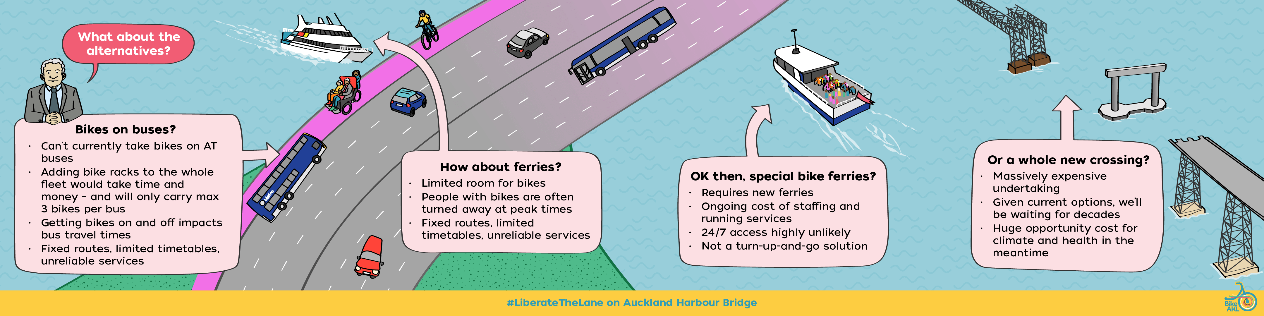
People deserve the freedom to make their own schedule!
The major appeal of walking, scooting, and biking is the sheer convenience and freedom of movement. Tying that to timetables defeats the purpose. And why pay when you can travel for free under your own steam?
Public transport is an essential option for crossing the Harbour Bridge, and a viable alternative for some people. But routes and stops are fixed and inflexible. Services can be unreliable or cancelled altogether, leaving people stranded. And bus and ferry timetables don’t work for every trip, especially when you start early or finish late.
Why wait to sit on a ferry or bus, or travel out of your way to find one, if you could simply use 15 of those minutes to walk, run, ride, scoot or wheel over the bridge, which is right there and available at any time? Additionally, walking and wheeling is a more climate friendly transport mode, creating zero emissions.
Everyone deserves to have a choice about how they get around, and we can liberate the lane to create that choice now. A 24/7 lane on the bridge gives people the freedom to make their own reliable journeys, free of traffic and independent of public transport constraints.
Bikes on buses?
Buses already struggle to meet passenger demand at peak times, and are currently not permitted nor set up to carry bikes.
We will continue to advocate for the option of carrying bikes on buses, especially while train lines are down. But it will not solve the problem of crossing Te Waitematā by bike. Retrofitting the entire bus fleet with front-mounted bike racks would still only carry three bikes per bus – tough luck families, groups, and anyone travelling at peak!
Liberating the Lane is the simple and speedy solution to enable Aucklanders to have greater transport choice.
How about ferries?
Ferries do currently carry bikes (with no extra fee above the standard ticket price), and we’re grateful that ferry operators strive to accommodate their customers who cycle.
Unfortunately, ferries miss the boat when it comes to meeting our emissions reduction targets, reliable journeys and hours of access. Like buses, ferries fill up at peak times, and are vulnerable to staff shortages, leading to interrupted journeys and stranded customers. Each ferry has a finite capacity for carrying bikes, and it is all too common for riders to be turned away if the ferry is full-up, making them an unreliable option for people trying to cross Te Waitematā with their bikes.
There’s also the cost of travel: many people tell us they go by bike in order to reduce the cost of their commute, and a ferry fare adds a significant cost to each journey. Liberating the Lane frees people from all of those constraints.
Special bike ferries?
Waka Kotahi and others have floated the idea of a dedicated bike ferry service. But these ferries would be as vulnerable to staffing shortages and capacity issues as any other public transport, likewise limited to fixed hours, and costing passengers for their travel. A bespoke bike ferry running back and forth below the bridge would be nowhere near as efficient, available, or affordable as simply Liberating the Lane on the bridge.
A whole new crossing?
What Aucklanders have been asking for ever since the Harbour Bridge was built – easy walking and cycling access across the Waitematā – can happen now at a fraction of the cost of a new structure, and in a fraction of the time. We need transport choice now.
Though Waka Kotahi’s new crossing options include walking and cycling, they would take more than a decade to build. In the meantime, there’s a huge cost in terms of climate, equity, and health. Freeing up a lane on the bridge now is cheap, fast, and easy – and we can do it as an interim solution so that we have transport options while the new crossing is still being built. One of Waka Kotahi’s proposed options even includes walking and cycling on the existing Harbour Bridge; if this becomes the preferred option they could simply leave the liberated lane in place, saving themselves time and money.
Freeing up a lane for walking and cycling is the smartest, simplest and speediest way to give Tāmaki Makaurau what it needs.
Let’s Liberate the Lane, NOW and make an accessible city the main event!
Bike Auckland commissioned SmartSense Ltd to investigate the feasibility of liberating a lane on the Auckland Harbour Bridge for active mobility – walking, cycling and other personal mobility options. Using Waka Kotahi data Richard from SmartSense has confirmed that Liberating the Lane for walking, cycling and wheeling is absolutely safe, viable, and can be done now!
The image here links to an A3 PDF. We encourage you to print out some posters for your local area!!
Relevant posts:
*28% of Aucklanders don’t have a (restricted or full) driver’s licence. The actual amount who won’t, can’t, or shouldn’t (due to impairment, medication, environmental values, or cost of owning a vehicle) drive will be much higher.