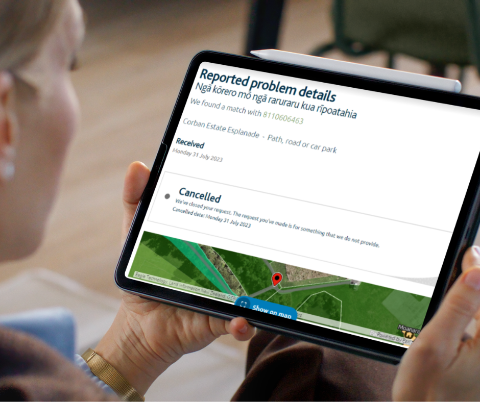
Auckland Transport is asking for feedback on improvements to Carrington Road. The ‘have your say’ closes on Friday 29 September 2023.
The improvements are intended “to support local housing development” by making “everyday journeys along this busy arterial safer and easier” and offering “improved travel options.” This means using the street more efficiently by making things better for people walking, biking and using buses.
Read on for our take, and a guide to helpful feedback. We recommend using your own words, and have provided some context and prompts to help get you started below:
Question 1: layout north of Woodward Road
We prefer the unidirectional cycleways because they will link up more consistently along the whole of Carrington road, as well as linking in to other cycleways which are planned for Point Chevalier and Mount Albert.
This means we support option 2; it’s the only one with unidirectional cycleways.
Explain your choice in your own words in the comment box.
Consider:
- the cycleways should ideally be 2.5metres wide. This would make them wide enough for overtaking, for whānau riding side by side, and for cargo and delivery bikes.
- We suggest that any widening or available space should be prioritised for future-proofed wide cycleways and footpaths, including plenty of waiting and turning space for people and bikes on each side of the Sutherland crossing (this is a key crossing for the North Western).
- all 3 options show a median strip (turning lanes for motor vehicles) in the middle of the road, which can only be achieved by unnecessary road-widening. This will drive up the cost of the project and create more congestion at parts of the road network which can’t be widened. We suggest reallocating this median to provide more space for wide cycleways.
Question 2: layout south of Woodward Road
Option 2 is the only one with unidirectional cycleways.
Explain your choice in your own words in the comment box.
Consider
- the need for better, protected cycle access across the railway bridge
- making sure the design integrates with the town centre links and future designs for New North Road
- supporting the reallocation of road space (from car parks) to provide for safe, accessible cycleways and convenient public transport
- ensuring there are mobility parking spaces provided nearby
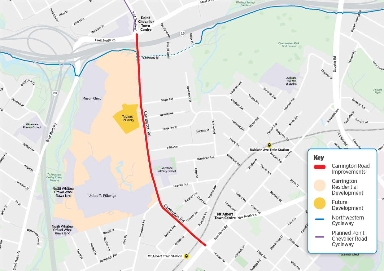
Carrington Road improvements
Crossing 1 at Prospero
Support this crossing. Ensure it is a raised crossing, even if it’s signalised.
Crossing 2 at Tasman
Support this crossing. Ensure it is a raised crossing, even if it’s signalised.
Crossing 3 at Sutherland
Support the relocation of this crossing to the North side of Sutherland road. This will create a more direct connection from the Unitec part of the North Western through to the Sutherland Road part of the North Western. If the crossing must be signalised (eg. if there is road widening) ensure that it is also a raised crossing.
Comment: there should be plenty of waiting and turning space provided for people and bikes on each side of the Sutherland crossing, especially if it is a signalised crossing. Overall a bike crossing on a major route for people using bikes should be easy to use with maximum safety, and must involve minimal delays and minimal conflict with pedestrians. Remind AT to future-proof this crossing for planned growth in ridership on the North Western cycleway, and that the design should be integrated with both the Unitec site and Sutherland Road.
General feedback box
This is the place to note Auckland Transport’s obligations to provide:
- Proper design for walking and cycling on the bridges – separated from traffic and each other, wide enough to meet accessibility standards. This likely would require widening on the Mt Albert rail over bridge
- Proper integration of cycling facilities with the other cycleways planned for Point Chevalier and Mt Albert
- Raised crossings (even if they are signalised), in line with the Safe System approach
Road widening – This feedback box is also a good place to make comment on the proposed widening of the road as part of this plan. In our view, the project should prioritise reallocating road space for walking, cycling and public transport, directing the budget towards quality facilities for people walking, cycling, and catching buses. This could mean removing the turning median and providing for walking and cycling in the existing corridor. In our view the road should not be widened just to retain this turning median. However, if it needs widening in order for the cycleways to be a good width (2.5m) we would embrace that, and it may need to be widened if it is to provide for bus only lanes (north of Woodward rd).
Consider…
- if you think the turning median is necessary on this corridor or if you would like AT to reallocate that road space towards more efficient modes (eg. walking, cycling, bus lanes). This could mean not widening the road at all or widening it less than the current proposal (resulting in cost savings too)
- what you think of widening the road corridor to ensure there is space for bus priority lanes going in both directions for as much of the road as is possible (north of Woodward rd).
- that more road space will add more risk at crossings and intersections. Even if that extra space is bus lanes it still means more danger for people and bikes crossing the 4 – 5 lane road.
- that if a road has more than two lanes of traffic any crossings must be signalised. This would mean a longer waiting time for people trying to cross the road. Consider if you think that waiting time is appropriate for a major cycle route (Northwestern), and whether it supports people to switch to cycling for transport.
Read on for some background if you have more time
An upgrade for Carrington Road has been in view since at least 2015. The route runs from the Mt Albert shops and train station to the Point Chevalier shops and SH16, linking locals to shops and transport. It’s also home to a primary school and several daycares, and sees the 66 bus every fifteen minutes.
Along the route, an additional 4000 homes are expected in the next decade or so, including highly visible development of the former Unitec site. So the government has allocated funding from its Infrastructure Acceleration Fund to support the transport needs of residents now and into the future.
The time is ripe for this long-planned upgrade. At this stage, Auckland Transport (AT) is seeking feedback on key design elements, rather than a finalised design.
But! The timeline for improvements is short, with construction from late 2025.
And a lot has changed in the decade since plans were first hatched. AT now has much stronger instructions today on safety and carbon reduction, and better design guidelines for cycling routes. We’re also in a climate emergency.
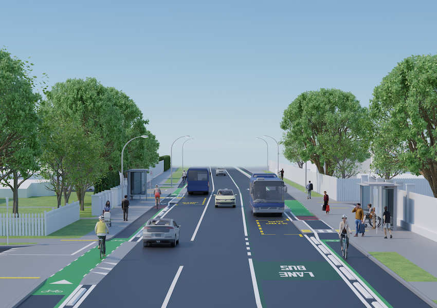
So it’s great that the plan includes separated, protected bike lanes the whole length of Carrington Road. This is a no-brainer in 2023.
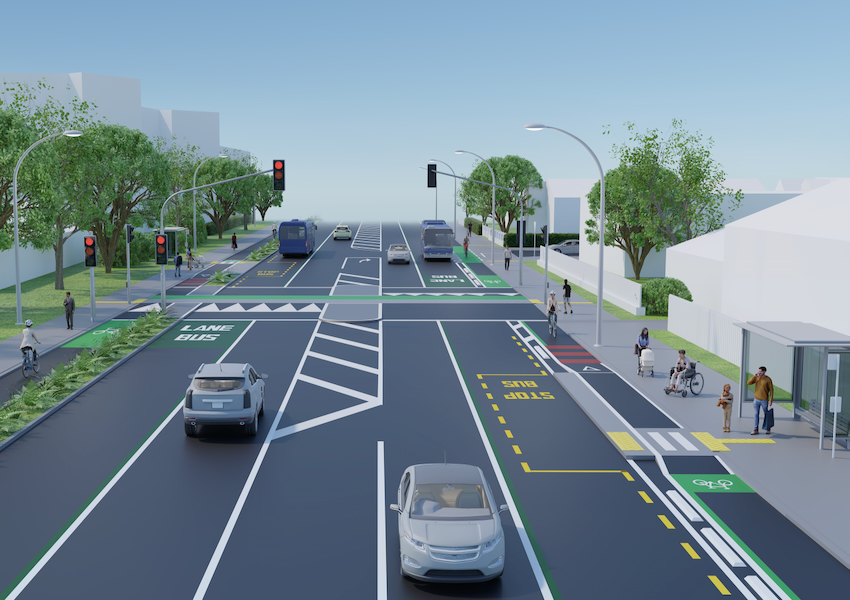
But they’re being designed in around other proposed features, including:
- multiple traffic signals. There are likely to be new traffic lights at each Unitec gate, and at Woodward Ave, as well as two new signalised pedestrian crossings, and potential signalising of the walk/bike crossing at Sutherland Rd. That means potentially eight sets of lights along the 1.7km from Pt Chev to Mt Albert.
- potential sections of dedicated bus lane. Again, the layout north of Woodward (allowing for stretches of bus lane on both sides) is different from what’s possible south of Woodward (only possible on one side).
And, the elephant in the room is that there is also some potential, and thus some temptation, to widen Carrington Road to “fit everything in” – but only the northern end, and only for a limited stretch, which would just shuffle any traffic bottleneck along somewhat.
We say, just because you can doesn’t mean you should. It’s 2023. Time to be responsible, nimble, smart and bold!
We think AT will do better by broadening its design approach, not the road, following the Transport Emissions Reduction Pathway. Putting people and climate first in the design will produce an outcome that’s safer, more sustainable and resilient, and quicker to deliver – as well as more affordable.
Start with generous and uninterrupted footpaths, shaded by plenty of trees, with rain gardens to soak up any deluges, and wide enough for mixed groups to stroll together, with crossing points at key locations.
Then add the protected bike lanes, designed to be consistent and continuous, generous and intuitive to use. They must be wide enough for families to ride side by side, and future-proofed for all kinds of wheeled mobility.
And then fit traffic around them, including buses and cars. There’s room on the whole corridor, we promise you!
Above all, build for success: Carrington Rd is a cycling artery
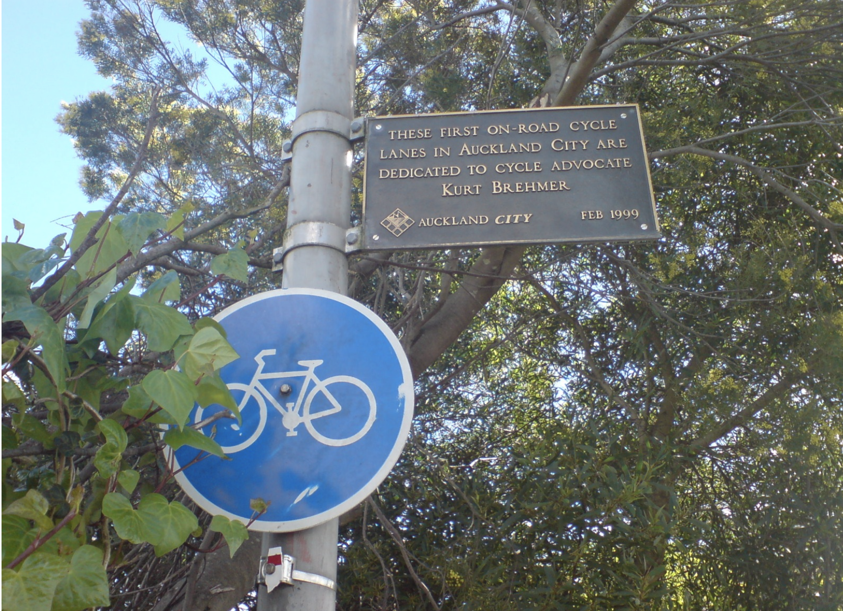
Fun fact: Carrington Road is home to Auckland’s first painted on-road bike lanes, installed in 1999 – there’s even a sign commemorating the fact.
It’s also a major crossing point for riders using the Northwestern Cycleway, which runs from Westgate to the city. A raised walk-bike crossing was installed at a later date and, around the same time, some concrete protectors were added to the SH16 overbridge.

This key crossing sees around 1000 bike movements a day, and up to 2000 in the height of summer, going by official bike counts at Te Atatū and Kingsland. In fact, since the conversation about upgrading Carrington road started in 2015, bike traffic has grown by 50%.
Local bike trips on and around Carrington Road itself have never been formally counted, but can be counted on to rise. With 4000+ new homes, that means thousands of new residents, which means many more potential bike trips to shops and transport links at each end, and schools and daycares along the way. Trust us, you do not want those 4000 new homes to be 4000 more cars! So, we need to provide other options for local trips.
On top of that, AT is under instructions from Council (via the Transport Emissions Reduction Pathway, aka TERP), to “supercharge walking and cycling”, with the goal of increasing cycling to 17% of all trips by 2030.
Around the city, narrow bike paths and shared paths are already coming under pressure. For example, the bottleneck along the Northwest Path through Kingsland, where Bike Auckland campaigned and won widening and separation.
So, any design for Carrington Rd must plan for success and be built to expect:
- a rapidly growing volume of Northwest Cycleway bike traffic pouring across at the Sutherland Road crossing,
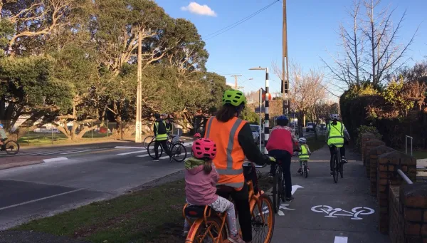
- a rising tide of local trips by people of all ages and stages, including children and families en-route to school, errands and social outings, and the many wheeled mobility options – scooters, cargo bikes, mobility devices, delivery bikes.
- many new cycling trips attracted once Carrington Rd is a safe ‘feeder route’ to the wider network – Northwestern Cycleway west to Westgate and East to the City Centre, to the Waterview Path to the southern isthmus and through Avondale to New Lynn, plus upcoming links through Pt Chevalier to the city, along New North Road, and more.
So, what’s Auckland Transport proposing for cycling?
The good news is that the consultation offers a range of quality options for cycling facilities. The mixed news is the potential for a messy “mix-and-match” approach. And the concerning news is some real fuzziness around key crossings and connections.
The simplest option on offer is one-way protected cycleways on each side of the road. This would tie in with the bridges at each end, which can only accommodate one-way cycleways.
We support the one-way option for its simplicity and legibility, with these stipulations:
- cycleways should be wide enough for side-by-side riding and overtaking (2.5m ideally), as per Auckland Transport’s design principles, and to accommodate all ages and abilities
- The design should avoid creating pinch points, and avoid using shared-path treatments to “solve” tricky design issues. Space should be prioritised to provide adequate and fully separated space for people on feet and people on wheels.
- In every case, the cycleways must be robustly protected from motor traffic, whether moving or parked.
AT is also seeking feedback on the option of a “bidirectional” (two-way) cycleway, on one side of the road.
Two-way cycleways do have some advantages – they are wider, which can be easier for trikes, family cycling, and overtaking. They work pretty well along uninterrupted stretches of road, like a waterfront or a park.
However, two-way cycleways introduce the potential for conflict (i.e. head-on crashes), and need careful design to ensure safe and intuitive movements at driveways, intersections, and access to and from the other side of the road.
The key complication with Carrington Rd is that it’s a game of two halves. North of Woodward Ave to Pt Chev is more flexible than south of Woodward Ave to Mt Albert.
And here’s the rub: AT says that north of Woodward, a two-way cycleway would work best on the west side beside the Unitec site. But south of Woodward, a two-way cycleway could only go on the east side, for terrain reasons.
A third option would be a mix of both: a two-way cycleway at the north end of Carrington Road, with one-ways on the southern end.
We’re not too keen on that because of:
- The need for a diagonal crossing for all bike traffic halfway down Carrington Road.
- How would a two-way cycleway segue into one-way cycleways at the bridges?
Moving the raised crossing (which was built in 2019) from south of Sutherland Road to north creates some potential to smooth the NW cycleway ‘desire line’, but this isn’t spelt out in the consultation material. AT should be cooperating on this with the housing development inside Unitec. And they should be making their thinking public.
However, this is being proposed in the context of widening this section of road to “add bus lanes”. And this is where AT’s thinking goes off-piste. Because only a short section can be widened, this doesn’t offer much advantage for buses, and has the effect of pushing any traffic bottleneck further down the road.
More worrying is what it potentially means for those using the crossing. If Carrington were to have 4 lanes for traffic here (plus a median for turning movements, as shown in AT’s images), that requires a signalised crossing (rather than a raised zebra crossing). If there’s a traffic signal, that requires plenty of room for waiting groups of people, including all types of bikes and mobility devices. We know how quickly the traffic islands fill up at St Luke’s Road, for example.
A signalised crossing also introduces more risks – including temptations to “shoot the gap” or run red lights across 4 – 5 lanes of traffic. Any such crossing should be raised to slow down drivers. But we are not convinced by the road-widening plan in general.
Proposed new crossings
AT also wants to add two, and maybe three, signalised crossings for walking and biking.
- at the southern end between Prospero and Willcott,
- at the northern end between Tasman and Fontenoy
- a new design for Sutherland Road where the NW cycleway crosses Carrington

These crossings make sense and we will be supporting them. The Sutherland crossing creates potential to smooth the NW cycleway ‘desire line’ here, which is good – this is not explicit in the consultation material but is indicated in the images from Malcolm’s blog post. It’s not clear whether AT is planning in tandem with the Unitec site, but they should be cooperating on this.
BUT: the prospect of widening this section of road is where AT’s thinking goes off-piste… not just that it just pushes the traffic bottleneck further down the road, but what it potentially means for those using the crossing.
IF Carrington were to have 4 lanes for traffic here (plus a median for turning movements), that requires a signalised crossing (rather than a raised zebra crossing), and IF there’s a traffic signal, that requires plenty of room for waiting groups of people, including all types of bikes and mobility devices. We know how quickly the traffic islands fill up at St Luke’s Road, for example.
A signalised crossing also introduces more risks – including temptations to “shoot the gap” or run red lights across 4 – 5 lanes of traffic.
This section should be raised to slow down drivers.
It’s also unclear what the plan is for Sutherland Rd itself… which is effectively (but not formally) a shared-space or bikes-first street. This could be formalised – there’s a daycare on the corner – and the crossing could be integrated into the entrance of Sutherland Rd.
Note: Waka Kotahi has unspecified plans to “optimise” Sutherland for safety; AT should be planning with them to make sure they integrate into this plan well
What about the bridges at each end?
The railway bridge at Mt Albert: AT says “We’re investigating widening the bridge for walking and cycling, to improve access to the town centre and train station.”
Improvements to this bridge are essential, given:
- the proposed closure of nearby level crossing, which is used by Gladstone Primary School’s walking bus among others.
- the current situation is not accessible or safe, with unprotected bike lanes, narrow footpaths, and a dangerously high kerb on the station side.
So this mustn’t be treated as a nice-to-have to “investigate”, it must be included in the design, and prioritised in the budget.
And if it can’t be done within the allocated budget, AT must reallocate road space to make room for safe walking and biking access to the shops and the train station.
The bridge over SH16 at Pt Chevalier: there’s a bit more room to play with here, but the same need for more holistic thinking. In particular:
- Cycleways must be properly integrated with the Pt Chevalier Road improvements, which are just about to get under way
- And this means re-designing the whole intersection to be as safe and easy-to-understand as possible for everyone walking and biking.
Again, this must be do-able within the budget, if AT resists the urge for costly super-sizing on the rest of the street.
Have your say now. Refer to our suggestions above if you need some prompts. Feedback closes Friday 29 September so don’t delay in making your opinion count.