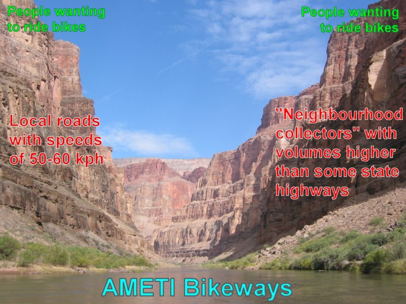
East Auckland’s new busway, AMETI, will be like a river through a desert, bringing top-notch cycleways and vastly improved public transport to a car-dependent part of the city. We’re delighted!
We strongly encourage you to support this project and ask for better bike feeder links on local streets, so even more people can actually use it.
Use this link to jump to the feedback section and have your say before Friday 16 November. And to learn more about this great project, simply read on…
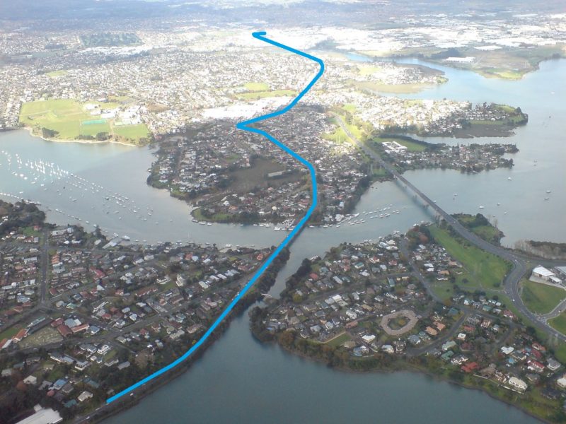
When you look at AMETI (the “Auckland Manukau Eastern Transport Initiative”), the first thing that strikes you is the scale. This is a project of massive proportions. A $1.4b rapid transit route similar to the Northern Busway will run from Panmure to Pakuranga to Botany. It involves rebuilding about 8 kilometres of roads, plus new bridges, fly-overs, and new walking and cycling routes.
In size, this project is comparable only to a few other transport projects we’ve ever had in Auckland, like the Waterview Tunnel, or the City Rail Link.
When finished by 2026, it will open the floodgates for public transport, which is currently unattractive and anemic in the East. And by 2046 (or earlier, if the Northern Busway is any guide), it is expected to carry 7,500 people in the peak hours per day – easily the equivalent of a new motorway, but without most of the downsides.
With East Aucklanders currently so deprived of any choices other than cars, it will be like a new river flowing through a desert.
It’s not too strong a metaphor. Because at the moment, well over 90% of people in the AMETI catchment area travel in private cars, a result of combining the suburban dream with car-centric designs of the 60s and 70s. Thankfully, the resulting traffic jams are about to get alternatives.
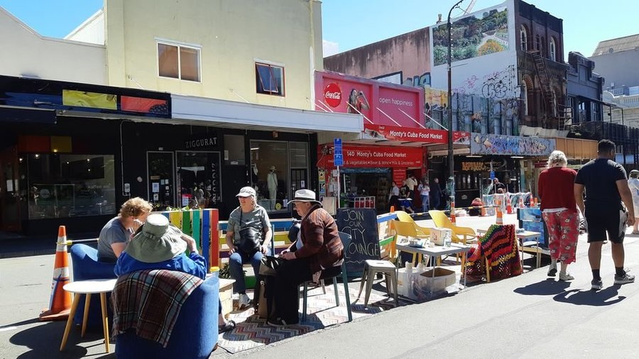
A Bike River for the East
Why is this important to people on bikes?
Well – that “busway river” will bring not only public transport flow, but also a brand new, best-practice bicycle superhighway that will make East Auckland the envy of the rest of us.
After many delays, the first 2-year construction stage of the busway has started construction between Panmure and Pakuranga. And with the funding for the rest of the route confirmed in ATAP, Auckland Transport is getting serious in finalising the designs for the next Pakuranga and Botany sections.
Bike Auckland and our friends from Bike East Auckland met recently to discuss with AT what those plans mean for people on bikes.
What’s changed for bikes?
As we discussed in previous blogs, the further east you go along AMETI, the better the bike designs become. This is partly because design expectations have increased over the years, and land acquisition for the busway has provided more space to work with.
Whereas the first section from Panmure to Panmure bridge offers “only” a wide shared path, once east of the bridge, people on bikes will get a proper two-way bike path with separate footpaths next to it. Easy riding in comfort, protected from cars, and without having to dodge pedestrians.
Pakuranga Town Centre
Once at Pakuranga Town Centre, the previous design iterations had one-way protected bikeways each side of Ti Rakau Drive all the way to Botany (still visible in this recent promo video). When we saw them years ago, we were very pleased – finally a project that included protected bikeways from Day 1.
But latest plans, as the AMETI team explained to us, have improved further.
Instead of protected one-ways on each side, there will now be two-way bikeways on the north side. These will be of the same general design as between Panmure Bridge and Pakuranga – running all the way to Botany on the northern side of Ti Rakau Drive.
We feel this will make overtaking easier than in the previous two-metre wide one-way bikeways. With old-school pushbikes, e-bikes and eScooters sharing bikeways these days, this will be important. It will also reduce the risks of riders “salmoning” the wrong way in the one-ways.
Talking of salmoning – that mainly happens when it’s just to difficult to cross a wide road to get to the one-way bikeway on the other side that you need. And Ti Rakau Drive will definitely be wide – wider than before even, keeping its four car lanes and adding two new busway lanes in the middle. So while the project provides this great two-way bikeway on one side, what about people on the other side of the road?
Well, the project team did think that through, and as a result, secondary parallel shared paths on the south side will serve local traffic. After a short trip, you can then cross at one of the various signalised walk/bike signals to get to the two-way bikeway! We think that is a great combo.


Sadly, AT’s promotion materials have not yet caught up to the two-way bikeways, so we don’t have great graphics for this yet. But this comparison with the current Quay Street Stage II design gives you an idea of what it will look like (bonus – Ti Rakau will have the trees between the bikeway and the road, giving an even more protected ride).
Whether you’re visiting a friend the next suburb over, shopping in the town centre, going to the movies at Botany, or using it as part of a longer commute, you will be feeling well pleased with this generous protected bikeway design!
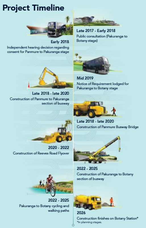
The bus and bikeway between Panmure and Pakuranga is expected to be complete by late 2020. The Pakuranga Station and Reeves Road Flyover (discussed below), will follow from 2020 to 2022.
Ti Rakau Drive to Botany
After 2022, AT will get into the longest section – Pakuranga to Botany. The works on Ti Rakau Drive will stretch for five kilometres; together with the first part to Panmure, it will be about as long as the current Northern Busway.
Again, the many plots of land bought for the busway to the south of the road allow for high quality bikeways through all the way, without notable compromises in quality.
And that will be mighty important – expect another blog shortly from our Bike East Auckland friends showing how unpleasant riding on Ti Rakau Drive currently is, and why they are so keen for the new bikeway. From a road that could make a new rider say “Never again!” after one try, this will become a pleasant run, with that “all ages and abilities” quality of best practice designs.
All in all, we have few to no real complaints about the proposed bikeways. Sure, the devil will be in the details, but from our meetings with the project team, we have confidence in that the designers are both skilled and willing to hear from us about things that matter to people on bikes.
An example: how do side roads and driveways get treated?
- Well, thankfully there are surprisingly few for a route of this distance. On the northern two-way bikeway, many houses already have their driveways onto local streets behind, not onto Ti Rakau Drive. On the south side, many houses were purchased and will be removed (with left-over land consolidated before some of it gets redeveloped, leading to fewer driveways).
- Turns will be almost all be limited to left-in / left-out, with drivers using traffic signals and solid median breaks to u-turn to their properties if they are coming from the “wrong” direction. This prevents the most dangerous movement for people crossing driveways on bikes – the right turning driver shooting across during a gap in heavy traffic.
- Additionally, the plans show raised table crossings for pedestrians and bikes across the non-signalised side roads. This will slow down traffic, and ensure clear priority.
- We still have concerns about the commercial / industrial section in Botany, where large trucks will cross the bikeway, often on very wide driveways. However, those designs are at a much earlier stage, leaving more space for improvement.
So with us giving the “Great!” stamp to the basic bikeway designs, is there anything that is more controversial?
Reeves Road Flyover – drawback or opportunity?
The Reeves Road Flyover tends to divide opinion.The proposal is to take all that car traffic that currently heads in along Pakuranga Road, and shuttle it past the southern side of the Pakuranga Town Centre on an elevated roadway running some half a kilometre, before sending it on towards Sylvia Park and the City. The flyover would thus remove significant amounts of car traffic from the first, westernmost section of Pakuranga Highway and the northernmost part of Ti Rakau Drive.
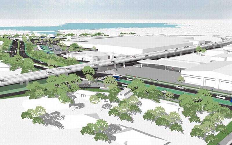
While we are certainly not all in favour of this new roadway, it has some benefits for bikes and buses.
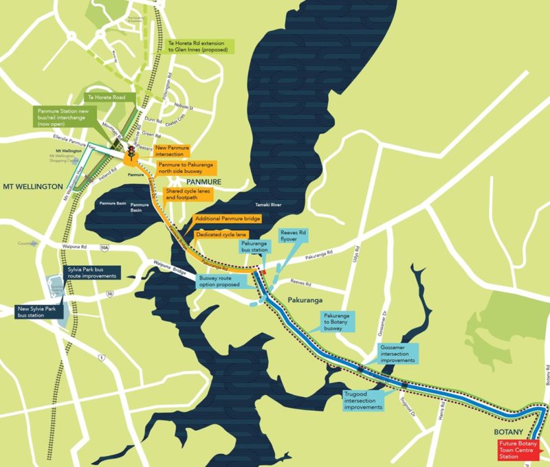
Using the route under the flyover, AT can run Howick buses onto the new busway more logically (see Page 5 here for more detail). For people on bikes, it has allowed the designers to add a proper dedicated two-way bikeway to extend from the intersection of Pakuranga Road and Ti Rakau Drive eastwards about as far as St Kentigern College.
You can see the new bike paths around Pakuranga Town Centre in our mark-up below.

This is not quite the “bikeway on Pakuranga Road” that locals have long dreamt of, but it’s another 500m of safety and comfort – and sets the expectation for what we might one day want to see going all the way to Howick! On the other hand, it could “lock in” the expectation that Pakuranga Road’s primary purpose will remain as a vehicle conveyor belt.
We are aware that the Reeves Road Flyover part of AMETI is highly popular among many locals and politicians in East Auckland, many of who are still very focused on car traffic. It is very much part of what they see as the “quid pro quo” needed to get the project across – as our Bike East Auckland friends occasionally find in discussing with their local neighbours.
As for the looks, the designers have talked a lot about how the underside of the flyover will be “architecturally designed”. For all that, it will still be a big structure shading and dominating the local street below.
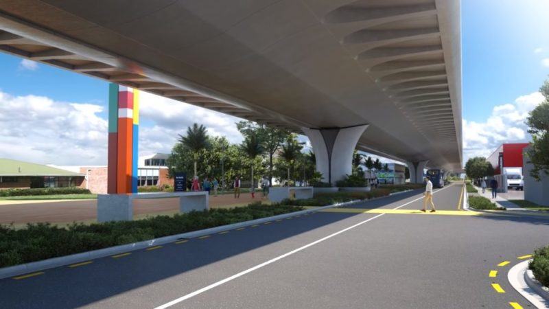
Ironically, in discussing the flyover with some of the people we had expected to be opposed to it, we’ve found some more positive views – for example, pointing out that one could possibly place shops and bars under its arches, in the style of the railway viaducts of London, Paris, Tokyo, while the covered expanse above could help shelter outdoor events from rain or extreme summer sun.
A clearly mixed blessing then, and it’s very unlikely that the flyover will change much at this stage. So instead, let’s talk about something that can and should be changed for the better…
So how will we even get to the new bikeways?
As you have seen above, we are pretty happy – strike that, VERY HAPPY – with the AMETI bikeways. And yet… Auckland is risking creating an asset people can’t use.
Why? Because compared to the high quality design ON Lagoon Drive, Pakuranga Road and Ti Rakau Drive, the surrounding road networks will remain extremely hostile to people on bikes. Remember the earlier river metaphor? These are the obstacles in your way if you want to get to it:
Some riders will certainly start using the AMETI bikeways immediately – be they existing, confident road riders, or new riders who are lucky enough to start or end their journey right on the AMETI bikeway. But for many, whether they can use these new facilities will come down to whether their local roads are traffic-calmed enough, or have bikeways themselves.
So that the “interested and concerned” can actually get to use the new AMETI superhighway, feeder bikeways are needed.
And those are sorely lacking right now. There are some patchy, limited facilities at the Panmure end. The Rotary Path near Pakuranga – a nice ride but hardly a transport cycle route. And some narrow recreational ride paths at the Botany end. Beyond that, pretty much nothing. All those residents east of Pakuranga for example? Unless they are already happy to ride in heavy traffic, they won’t get to use the AMETI paths.
Now, we want to be clear – this is not a fault of the AMETI project itself!
Any project has to stop somewhere, any budget has a limit. And the AMETI team has stated willingness to work on feeder bikeways within their project scope – like the start of Gossamer Drive, or the first part of Pakuranga Road. But it’s not that much – and for reasons of scope, it can’t be.

What else is on the cards? Nothing from Auckland Transport – the 10-year cycling business case has no funding areas in the east. The closest that is currently funded are some works in Glen Innes, 5+ years away.
The original intention was to allocate funding for Pakuranga-area works, but while the ATAP funding sums for bikes were substantial, they did not cover the full business case areas.
What can be done to avoid this lack of access?
In our view, it is clear that the lack of access cannot stay that way – it would be like building a motorway without interchanges, or a busway without bus services to run on it.
While there’s some years still to go, we need Auckland Council, Auckland Transport and the Local Boards to work together to make sure the new bikeways are useful for more than existing riders and immediately adjacent residents.
A number of approaches are needed here:
- The project team needs to make access onto the bikeway within their designation as safe and easy as possible. We are working with them on this already. Your voices will support us here.
- Auckland Council and Auckland Transport need to put more budget into walking and cycling, at least in the second half of the coming decade. The good news is that so far for the last decade, every year has seen the case for cycling grow. We think there’s a good chance for more investment if cycling keeps rising as it does.
- Auckland Transport needs to be serious about walking and cycling safety, and leap at opportunities to include bike improvements on any major road projects or intersection reconstructions. Sadly, as we found on Botany Road – just a kilometre from the end of the proposed AMETI bikeway – there is a strong reluctance to do that. To our eyes, that’s worse than leaving money on the table. Because once AT finally gets around to it, retrofitting bike facilities will be significantly more expensive to do down the line, than it would be to do it right now whenever rebuilding an intersection.
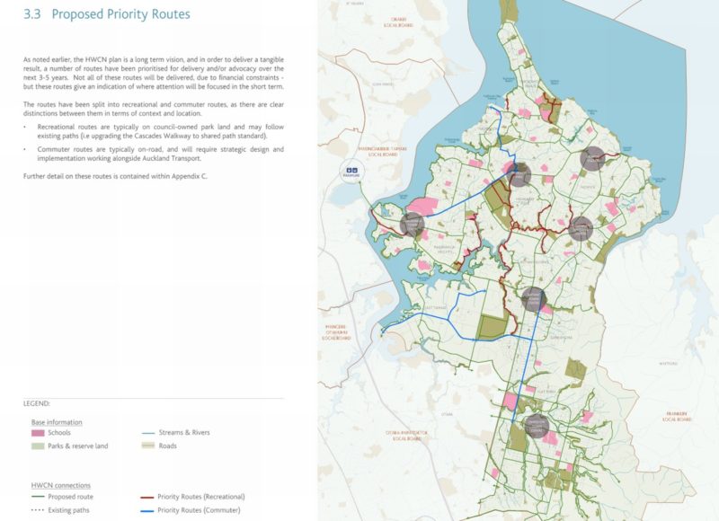
- Local Boards should help make these new superhighways accessible for their local residents – and there is a glimmer of hope in the recently adopted Howick Walking & Cycling Plan (formerly this would have been a Greenways Plan). As shown below, this includes some key routes which would support the AMETI bikeways. Again however, this will need people to support and push for it.
Current consultations: HOW YOU CAN HELP!
Consider adding your input to the two AMETI consultations currently underway, to help push a great project even further in the direction of excellence. Consultation closes on Friday 16 November.
Our suggestion for key issues to raise:
Question 5:
- Strongly support the busway as boon for East Auckland
Question 11:
- Strongly support the protected two-way bikeways as a great improvement for cycling safety and convenience
- Support the “local access” shared paths
- Support all unsignalised crossings over the bikeway to have raised tables and be left-in / left-out only
- Ask for the addition of more side accesses, including but not limited to along Gossamer Drive
- Ask for more feeder bike routes funded by AT and the Local Boards, in time for opening in the mid 2020s
Our suggestion for key issues to raise:
Question 5:
- Strongly support the busway as boon for East Auckland
Question 9:
- Strongly support the protected two-way bikeways as a great improvement for cycling safety and convenience
- Support the “local access” shared paths
- Support all unsignalised crossings over the bikeway to have raised tables and be left-in / left-out only
- Ask for the designs to carefully consider commercial driveways (trucks turning risks, and waiting trucks blocking the paths)
- Ask for the addition of more side accesses, including but not limited to paths along Botany Road, and extending the bikeway another 300m further east to Chapel Rd intersection
- Ask for more feeder bike routes funded by AT and the Local Boards, in time for opening in the mid 2020ss
Background links
- Stage 2 & 3 AT Newsletter
- Stage 2 plans (Pakuranga)
- Stage 3 residential plans (west section of Ti Rakau Drive)
- Stage 3 commercial concepts & brochure (east Section of Ti Rakau Drive)


