
The last cycleway gap north of Nelson Street is about to be closed, and Lightpath will finally have a proper connection to the waterfront! After much discussion of possible routes, Auckland Transport has settled on a tidy zig-zag: up the west side of Market Place (hooking into the future Westhaven route), then along the north side of Customs Street West, before going up the west side of Lower Hobson Street (where it connects with the Quay Street Cycleway).
As always, Bike Auckland will be providing detailed feedback to AT – and we strongly encourage you to add your support using the easy online form. Some locals may not like that Market Place is to become one-way for cars, so your voice very much counts! Feedback is open until Sunday 1 October.
See below for a quick guide to feedback

A quick guide for online feedback…
1. What do you think of the design?
We strongly support it – build it now! A completely protected two-way route joining the Nelson Street path with the Quay Street Cycleway is a great outcome.
2. How would you improve it?
Review the design for the intersection of Market Place with Pakenham Street East, to see whether markings and kerbs could be simplified further. Why? Because southbound cyclists face two sharp 90-degree turns, whereas the desire line would be more of a diagonal.
3. Which loading zone arrangement do you support?
Option D is likely to be best: it provides the most loading zone flexibility, which reduces risk of issues with parking on the cycleway.
4. Any other comments or suggestions?
On Customs Street West and Lower Hobson Street, the cycleway should NOT be flush with the footpath, for two reasons:
- As seen on Beach Road, where it’s a huge issue, pedestrians can unknowingly stray into bike space, and a little bit of vice versa, when the areas aren’t strongly differentiated. We strongly recommend a slight height difference between cycleway and footpath – with a ramped kerb between, to allow access across for e.g. delivery hand-trucks.
- We’re also concerned that drivers will be tempted to park on the cycleway on Lower Hobson Street to load deliveries, drop off taxi passengers, etc. So we recommend the outer kerb be designed to prevent easy vehicle access onto the cycleway.
A closer look…
The full Auckland Transport details and plans are here.
Market Place (detailed plans here)
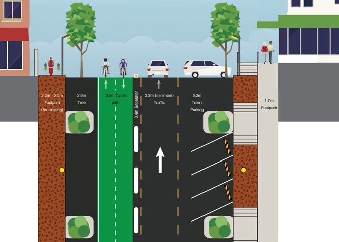
- A two-way cycleway (3.0m wide) at road level on the western side of Market Place, separated from traffic by raised islands (and at driveway crossings by rubber speed humps).
-
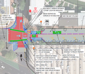
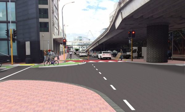
The Pakenham St/ Market Place intersection markings. A rather complex set of markings on the Market Place / Pakenham Street West intersection will switch cyclists from the one-way-each-side on Nelson Street to the new two-way cycleway. We’re not too worried about safety here, as it will be on a raised table with traffic slowed down somewhat – but we wonder whether it could be simplified a little more…
- Vehicle traffic on Market Place becomes one-way/ northbound only – we understand AT did a lot of one-on-one consulation in the last months, but this may still be controversial.
- Angle parking on the western side of the road is removed (in the long run, larger footpaths might be added in between the trees?).
- Parking on the eastern side changes from parallel to angle parking (to partly balance the car spaces lost on the west side).
- The trees stay in the picture.
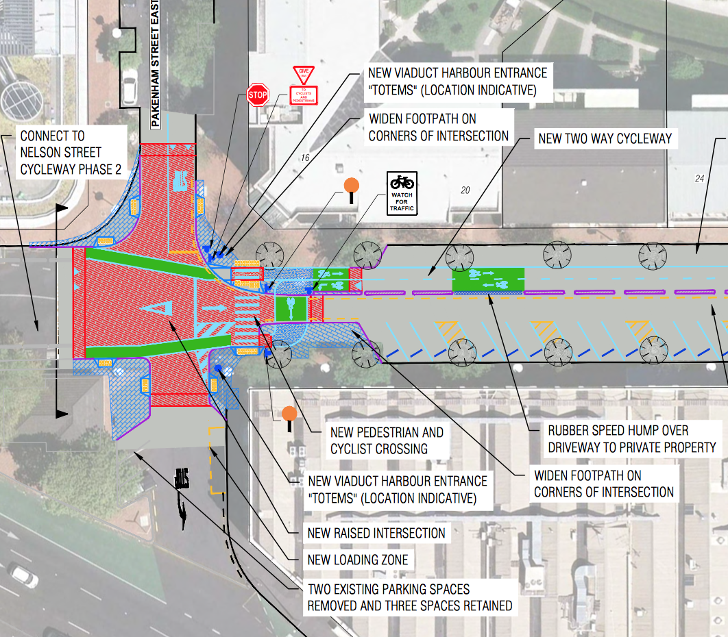
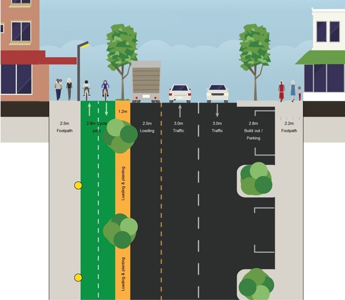
Customs Street West (detailed plans here)
- A raised table at the intersection of Market Place and Customs Street West – a good solution in itself, but it means the 90 degree left turn for southbound riders is rather tight.
- A two-way cycleway (2.8m wide) on the north side of the road – the width is slightly narrower than ideal, but should be okay in practice.
- Walking and cycling sections will be delineated with paint and/or texture. We DON’T support this – it simply doesn’t supply strong enough cues, as we can see on Beach Road. Without stronger separation, it is likely we will have lots of pedestrians walking in the cycleway. Our take: there should be a clear vertical difference, with for example a ramped kerb so deliveries can still access the footpath (see next point).
- A 1.2m buffer / tree zone at path level as a landing area for deliveries. Delivery people and other users would need to cross the cycling space, but we don’t see this as a major issue in itself, since their vehicles will not be on the cycleway, as seen in other locations.
- Four car parks on the north side will be removed to make space for a longer loading zone; angle parking on the south side changes to parallel.
- Some trees may be removed / relocated, but most stay as they are.
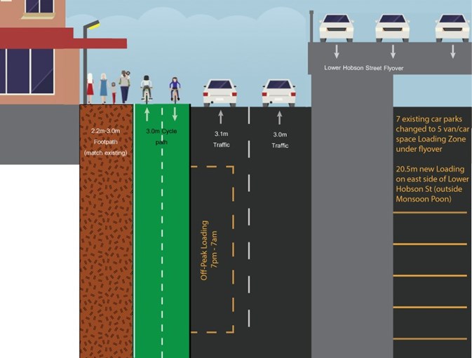
Lower Hobson Street (detailed plans here)
- A two-way cycleway (3.0m wide) on the west side of the road, level with the footpath.
- Walking / cycling sections will be delineated with paint and / or texture. As on Customs St West, we DON’T support this. It doesn’t give strong enough cues, as we can see on Beach Road where lots of pedestrians walk in the cycleway. There should be a clear vertical difference, which can include a ramped kerb so deliveries can still access the footpath (see next point)
- We have concerns that drivers will park on the cycleway of Lower Hobson Street itself to load up, drop off passengers from taxis etc – especially when the loading space is a clearway during the day time. The outer kerb design should therefore prevent easy access onto the cycleway. One way of doing this is by using a rather high kerb, 200mm or so. This could include intermittent dropped kerbs for access by hand trucks, etc, from the off-peak loading zone – but it should be designed to prevent casual parking on the cycleway itself.
- Bus parking moves away from the area.
- Loading and taxis move to the outside edge of the new cycleway, and take place 7pm – 7am. This allows for 2 northbound traffic lanes in daytime (with options for daytime deliveries using the space under the Lower Hobson Street viaduct).
- At the lights where Customs Street West meets Lower Hobson Street, a raised crossing will provide flush access between the new loading zones under the overpass and the western side of Lower Hobson Street – and will also provide some traffic calming and thus extra pedestrian protection for the area.
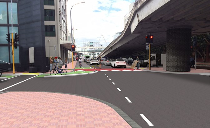
And it’s not all about bikes…
The project includes improvements that will make life nicer for pedestrians as well as people on bikes.
These are concentrated at both ends of Market Place:
- Raised tables to slow down traffic
- Kerb build-outs to reduce crossing distances.
- Dual-use zebra crossings (pedestrians and people on bikes get right of way)
Plus, there’s a raised table for the signalised pedestrian crossing over Lower Hobson Street, in part to make it easier for deliveries to cross here).
Overall, this is a rather strong improvement – but we need your support to ensure that drivers and pedestrians don’t stray into (or park on!) the future cycleway. Please add your feedback now – and flick back up to the feedback section above for our quick guide!


