
“As a Vision Zero region, Auckland Transport wants to make sure everyone gets home safely.” It’s heartwarming to read these words in AT’s press release about the Home Free Christmas travel offer, and we expect to see the same commitment at the heart of every one of AT’s road projects. But in the rush towards Christmas, we’ve found a glaring gap…
Auckland Transport and Waka Kotahi/ the NZ Transport Agency are currently consulting on two projects in the Southwest Gateway Programme planned for completion by 2021: 20Connect (an NZTA project) and Stage 1 of Airport to Botany (A2B) Rapid Transit (an AT project).
This forms part of a major strategic network of national, regional, and local importance, and the current focus is on delivering ‘early improvements’ to meet the Americas Cup and APEC deadline. Feedback closes this Sunday 8 December, at a very busy time of year.
So we can all be forgiven for feeling a bit rushed on this one, and perhaps not look too closely at it.
But it’s time to pay attention – because one part of this project sacrifices local bike safety, another part has had bike safety improvements put on ice for lack of funding, and the overall vision for safe riding through the Airport area remains fuzzy. This is just not good enough for a 2021 project of such strategic weight.
That’s why Bike Auckland is calling for a rethink. And we’d like your support!
How you can help: a quick feedback guide
The feedback survey consists of 8 questions. Feel free to use our statements below as inspiration for your own thoughts. Thank you!
Feedback closes 5pm, Sunday 8 December.
1. What do you think of the Airport to Botany Rapid Transit preferred route?
Bike Auckland opposes the removal of the cycle lanes on Puhinui Rd east of the station with no provision for a safe, direct and convenient alternative access to the Station for the Papatoetoe community surrounding the station.
2. Do you have any other comments or suggestions around the wider Airport to Botany Rapid Transit project?
The project must be planned and designed to integrate and expand the safe cycling network for Manukau and East Auckland, and Bike Auckland as the key cycling stakeholder looks forward to working on this with Auckland Transport.
3. What do you think of the 20Connect preferred improvements?
Please fund and complete both SH20B and the Mangere Bridge/Mangere/ Airport Oaks project as part of the 2021 package of works.
4. Do you have any other comments or suggestions around the wider 20Connect project?
See above. We call for a more integrated and coherent approach across the project area, that ensures safety, continuity, and access for active modes.
5. We are proposing bus priority lanes along Puhinui Road and Lambie Drive, between 6-10am and 3-7pm, Monday to Friday. What do you think about these proposed operational times?
Please extend the priority bus lanes hours to all day, 6am to 7pm, to provide a safe travel option for experienced cyclists who don’t need a separated cycling facility such as the shared path cycle lane on Puhinui Rd west of the Station to SH20.
6. What do you think of the walking and cycling improvements along Puhinui Road and Lambie Drive, and what would encourage you to walk and cycle in this area?
There are no cycling improvements planned for Puhinui Rd east of the Station, and this should have been spelt out in this question to ensure feedback is reliable and informed. The gap this project would create will not only actively discourage cycling in this area but also represents a huge missed opportunity to integrate active transport into the new Puhinui Interchange. Please take the time to redesign this section with input from public stakeholders for active transport, and with a Vision Zero lens across the work.
7. What do you think about the current speed limits along State Highway 20B?
They are not appropriate for the predicted growth in traffic volume on the road, as well as for more people cycling.
8. What do you think about the proposed speed limit change along State Highway 20B?
Reduce to 60k/hr. At the same time, why isn’t the speed limit on Puhinui Rd east of SH20 also under review? Please reduce it to 30 k/hr to account for the school, the unsafe dogleg, and the expected increase in people walking and cycling to Puhinui Station.
So what’s the story?
The good news is that both projects currently up for consultation include cycling improvements. NZTA’s priority bus lane on SH20B and part of Puhinui Road will replace the existing wide shoulders (currently used by some cyclists) with a separated off-road shared path to cater for people commuting by bike to and from the Airport. And AT is proposed some protected bike lanes on Lambie Drive.
However, three major issues are ringing alarm bells at our end:
- In its section of the project, AT is proposing to remove all existing bike lanes on Puhinui Road, in order to fit the busway within the existing road space. West of the station, the plan is to add a shared path on one side of the road. East of the station, through a residential section and past a primary school to Lambie Drive: nothing. We’re shocked at how little forethought there has been for how to heal the gap this will create in the cycling network.
- Meanwhile, a lack of funding has paused the 20A Project for safe and continuous bike routes through Mangere, Mangere Bridge, and Airport Oaks. In other words, in the midst of all these early improvements, an active transport project that would enhance access to jobs in an area of greatest need, including new more intensive housing, is languishing for want of investment.
- And there’s a glaring ‘black box’ around what’s planned for the airport land. We all need to know how people will ride safely through the airport space, and how those routes will connect to the wider network.
Altogether, the situation doesn’t strike us as strategically coherent. Nor is it equitable, healthy, or future-proofed. Moreover, we’re worried that in the hurry to meet arbitrary event-based deadlines, local communities will suffer, opportunities may be foreclosed, and the big vision will fail in its key goal of achieving mode shift.
Auckland, its airport, and its people deserve better. So we’re putting it on the record: we’re deeply concerned by the gap in AT’s thinking here. We’re troubled by the casual sidelining of cycling and micromobility in what should be an integrated vision for safe and equitable transport choice. And we remain perturbed by the lack of clarity around connections through the Airport land.
Bike Auckland acknowledges the wider strategic value of the overall project, the necessity for better public transport options through this part of Auckland, and the vital role of of a rapid transit network in achieving mode shift.
Our concern is safe travel for people of all ages in the communities through which the new bus route will pass – including access to and from the airport for the 20,000 who already work there, and the 27,000 more expected to join that workforce in the next 30 years.
So we’re calling on AT to re-scope Stage 1 of its Early Improvements project to focus solely on the area west of the new Puhinui Interchange.
Why? Because the current design for the area east of the station (connecting Puhinui Station to the Manukau Interchange) removes existing bike lanes, creating a gap in the planned cycling network, and offering no meaningful alternative. That’s simply unacceptable in 2020. This section deserves a more attentive, safer, multi-modal design approach, and should not be rushed.
Secondly, we suggest that the investment freed up from this section be directed instead towards earlier delivery of for 20Connect to provide safe local cycling links for Mangere Bridge and Mangere to workplaces in Airport Oaks, the 20A cycleway and the wider Airport Precinct.
Why? Because doing this would deliver more multi-modal options, sooner, across a wider area, improving equity of access for South Aucklanders, both for local trips and longer commutes. And it will save the project from a perception that locals on bikes are being, as it were, ‘thrown under the bus’ when it comes to threading the A2B rapid transit route through neighbourhoods.
Thirdly, we’d like more transparency and more public engagement around the plan for bike routes through the Airport precinct.
Why? Because the people who will use these routes need to know they’re fit for purpose, and we all need to see how they tie in with the surrounding network.
We trust the three big players in this story – AT, NZTA, and Auckland Airport – can find a way to get around the table and work this one out. We’ll be escalating our concerns until they do.
Read on to find out more about each section of the project, our specific concerns, and – at the end of this post – our suggestions for your feedback.
An overview of the Southwest Gateway Programme: what’s the goal?
Designed to improve access to the Airport, the Southwest Gateway Programme is made up of short-term and long-term (30 year) transport projects designed “to connect communities, and support population, business and airport growth.” Some 20,000 people presently work at the Airport and 800 other businesses in the Airport Precinct, and over the next 30 years these numbers are expected to grow to 27,000 full-time jobs.
Previous public feedback on the plan, gathered in 2017-2018 as part of the Single Stage Business Case for funding the work, identified a need “to provide better public transport, walking and cycling facilities to match population growth; improve safety and to improve the efficiency of freight. Together this will improve access to jobs, education and social opportunities, support economic prosperity and provide health, cultural and environmental benefits.”
 The two projects currently up for consultation represent – or should represent – the first step towards these goals. Both are centred on Puhinui Rd (including the SH20B section of Puhinui Rd), a route that figured highly in the public engagement report, along with calls for good walking and cycling links:
‘Walking and cycling were the second most common topic of all the feedback we received. There was a lot of interest in cycling along SH20B (SH20B/Puhinui Rd) between Puhinui and the Airport. This high level of interest is a good indication that public expectations for good walking and cycling will be high for these projects.
Most of the cycling comments indicated shift workers would use an upgraded cycling network at times when public transport was limited, or would use cycling as an alternative to both private vehicles and public transport.’
So you’d imagine that safe, integrated cycling facilities would be part of the design thinking at every stage of this programme, right? And that the early improvements would leap on opportunities to get that right? Let’s take a closer look…
PART ONE OF THE CURRENT PICTURE: AT’s Project for Puhinui Rd and Lambie Drive
This is the section we have the strongest concerns about.
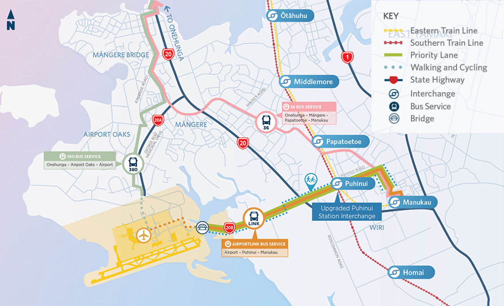
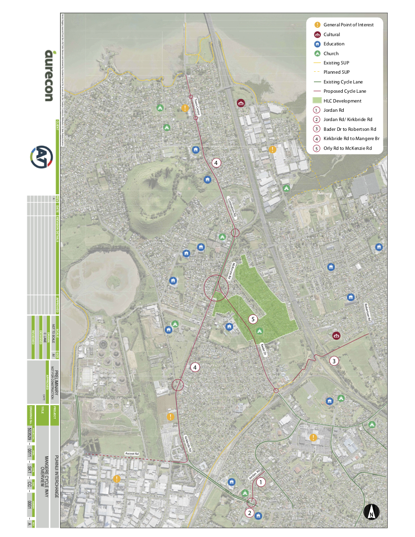
This project forms Stage 1 of the Airport to Botany (A2B) Rapid Transport Upgrade, which will ultimately enable more frequent rapid bus connections from the Airport to East Auckland, via Papatoetoe and Manukau.
The current design centres on Puhinui Rd, an important local arterial that connects Great South Road, Lambie Drive and SH20, and intersects with the railway line at Puhinui Station – which is undergoing a $60m upgrade to become a major new Interchange for airport travel.
Currently there are on-road cycle lanes on both sections of Puhinui Rd, east and west of the train station. These are heavily used by recreational cyclists during the weekends, plus commuters during the week, and smaller numbers of local bike trips, as well as other small wheeled vehicles. East of the station, you’ll also find Puhinui Primary School with a wide frontage onto Puhinui Rd, and two dairies.
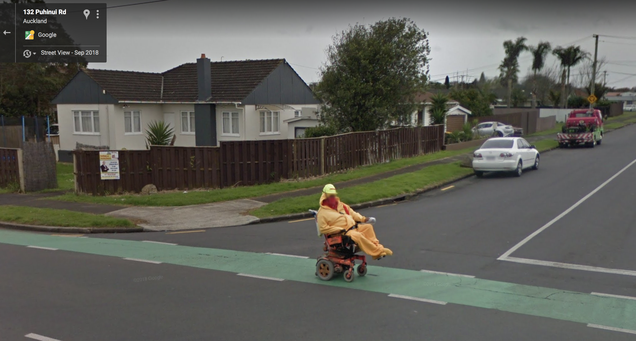
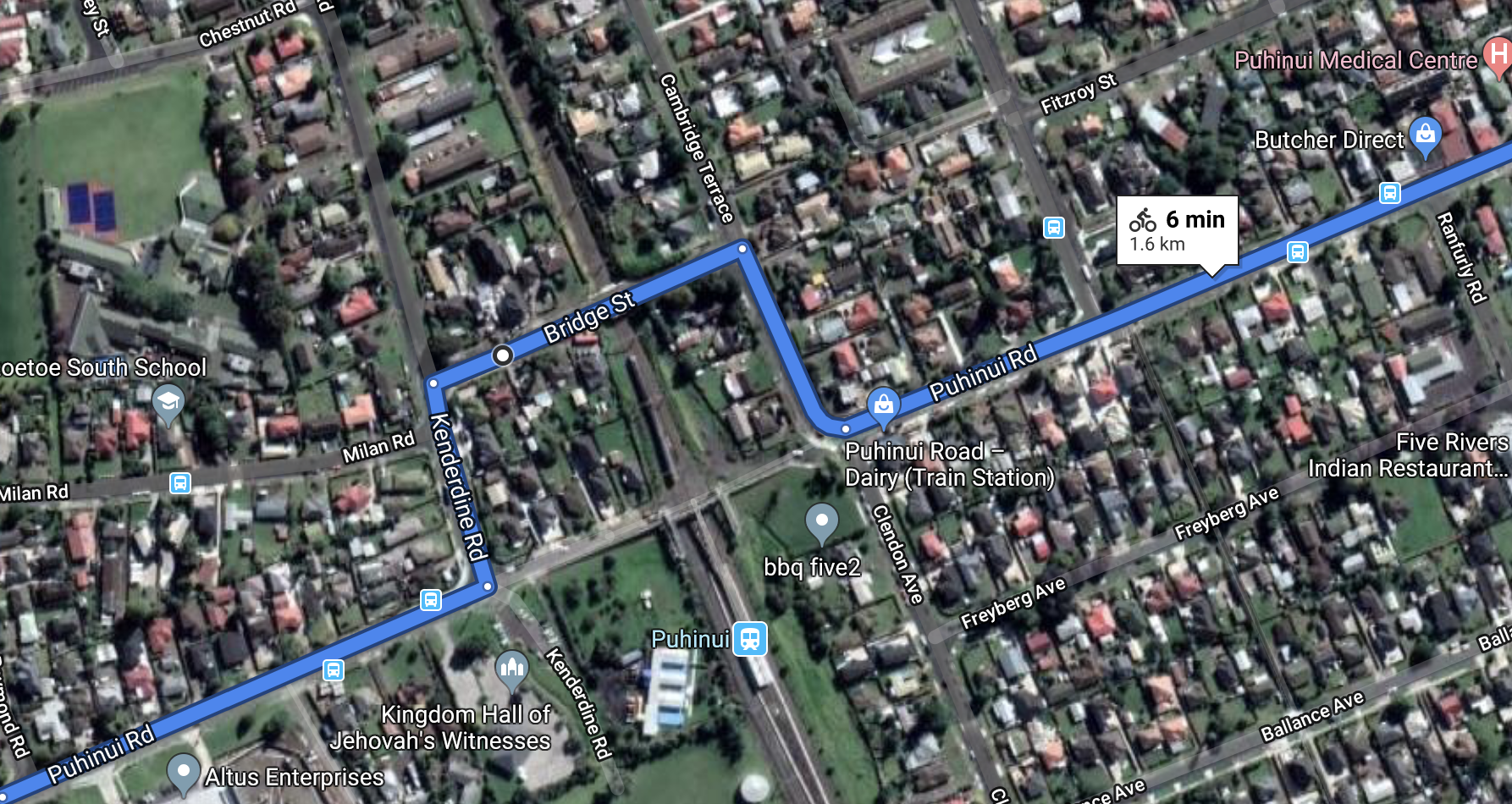
There’s a key design constraint: where Puhinui Road intersects with the railway line, it briefly ‘disappears’ – jogging sideways into a dogleg up and over the railway line, via Kenderdine Rd, Bridge St and Cambridge Terrace.
The dogleg up and over the railway line is a particularly tricky point to navigate on a bike. West of the station, the bike lane sends you onto the footpath near the intersection with Kenderdine Rd. Green marking on the footpath then directs you towards the dogleg, across the road to the footpath on Bridge St. You then need to rejoin the road at Cambridge Tce, before being directed back onto the footpath again to turn onto Puhinui Rd. The footpath cycle route ends with a ramp back onto the Puhinui Rd bike lane, opposite Clendon Rd near the train station.
In the current design, people on bikes will share this challenging section with a frequent bus service.
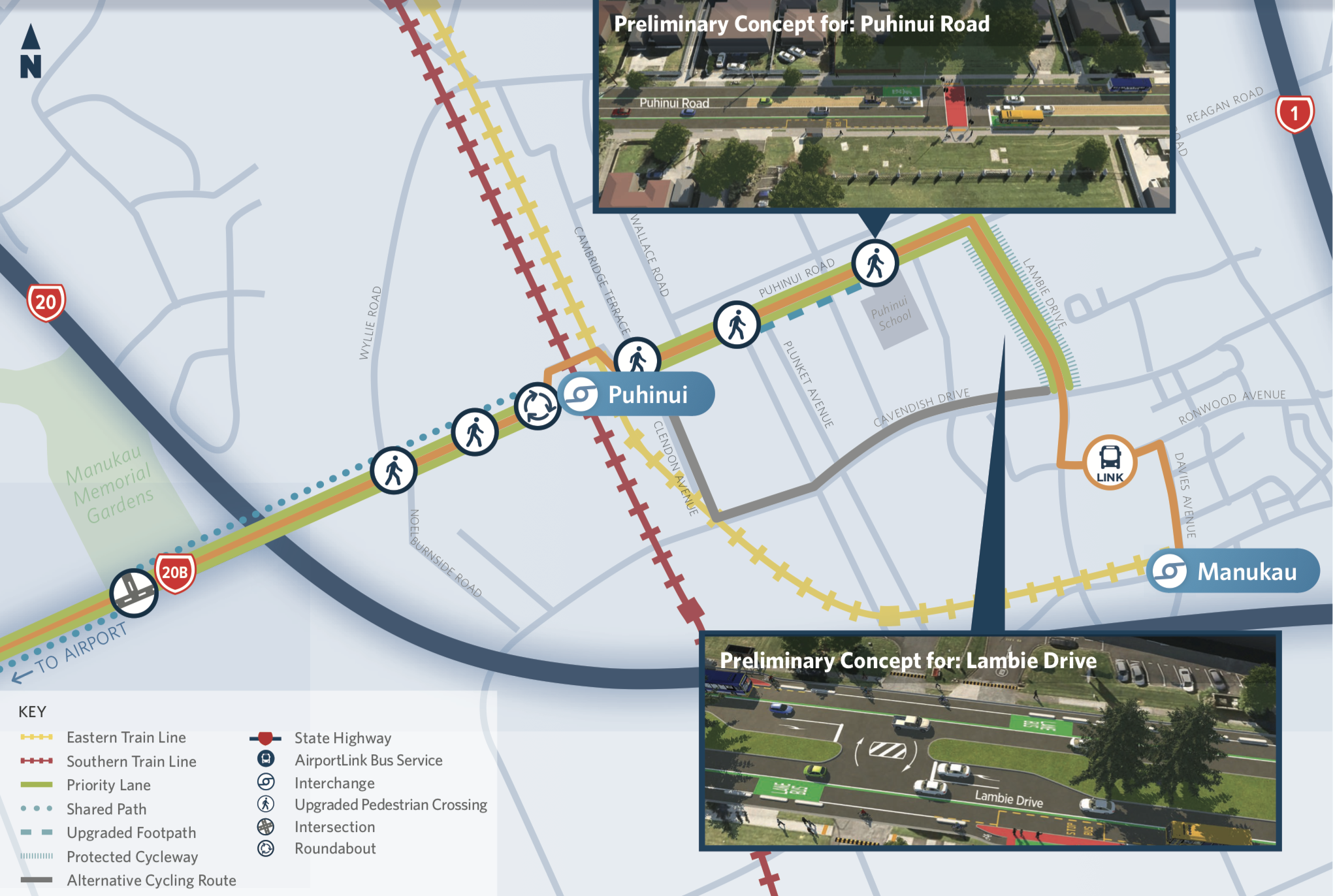
AT’s proposed changes for Puhinui Road and Lambie Drive:
- Replace the existing 1.2km of on-road cycle lanes on both sections of Puhinui Rd, east and west of Puhinui Station, with a new vehicle lane for peak hour Airport bus priority.
- The peak-hour bus lane will operate from 6am to 10am and 3pm to 7pm, Monday to Friday. Outside these hours, on-road parking spaces will be increased from the existing 112 car parks (by our count) to 227. This creates new hazards of ‘dooring’ people biking on the buslane outside of peak hours. How is that consistent with Vision Zero?
- The existing Lambie Drive on-road cycle lanes will be upgraded to protected lanes. A new bus stop on Lambie Drive creates safety issues for people on bikes and bus passengers. Safety treatments will be needed to alert people using driveways on Lambie Drive to give priority to people on the bike lanes.
- Two new bus stops will be provided on Puhinui Rd between Wyllie Road and Noel Burnside Road.
- The footpath between Ranfurly Rd and Puhinui School will be widened. However, it will not be a shared path for cycling. As a result, there will be no replacement safe cycling facilities on Puhinui Rd east of Puhinui Station.
- A very short length of painted bike lane will remain on Puhinui Rd beside the dairy on the corner of Clendon Ave – however, as designed it runs outside the parking spaces and will thus lock in the ‘dooring’ risk for people on bikes.
- West of the station, a new 2.5m-3m wide shared path for walking and cycling will be provided on Puhinui Rd, ending at a new roundabout with raised tables for safer connection to the station.
- The constrained Bridge St dogleg is out of the scope of AT’s project. This means there will be no safety improvements to the dogleg, despite the fact that people on bikes negotiating the switches between footpaths and road space will be faced with much more frequent bus movements through this already risky zigzag.
- Raised tables at a number of side streets on Puhinui Rd are proposed for safer crossing by people walking and on bikes. However, no safety treatments are proposed for the crossings at Clendon Ave, Wallace Rd, Bridge Street, Cambridge Tce or Kenderdine Road.
- Existing pedestrian crossings are proposed to be upgraded and signalised to improve safety and access to shops, schools and parks – however, details are not provided in the consultation material.
Our position on AT’s proposed changes for Puhinui Road and Lambie Drive
Notwithstanding the plan for protected cycleways on Lambie Drive, the proposed changes to Puhinui Rd constitute a major alteration to the regional cycling network. This will seriously detract from the attractiveness and safety of existing cycling on the road, and deter growth in bike commuting to and from the Airport. This design fails to respond to the public call for more safety and choice so staff at the Airport and Airport Precinct workplaces feel safe to commute by bike.
We propose that Auckland Transport put this section of the project on hold until a multi-modal, Vision Zero-compliant design can be completed.
PART TWO OF THE CURRENT PICTURE: NZTA’s 20Connect project for 20B/ Puhinui Rd
This section is basically fine, assuming good connections westward (Airport) and eastwards (AT)
As reported in our August edition of Project Watch:
“Bikeways are coming to SH20B, as part of the 20Connect project. This joint NZTA/ AT/ Auckland Airport project aims to improve airport connections, with safety improvements and priority bus lanes to allow buses to run every ten minutes between the airport, the soon-to-be-upgraded Puhinui Station, and Manukau.
A new shared path will run along the north side of SH20B, from SH20 to the Manukau Memorial Gardens with a signalised crossing switching the path to the south side of SH20B. This work is set for completion by 2021.”
These works cover the 3km between SH20 and Pukaki Bridge, where the Airport’s land begins. In between, the Manukau Memorial Gardens are on the north side of the road, and there’s a large Airport-owned site on the southern road frontage, which the Airport intends to develop as a new park and ride.
Currently there are no cycling facilities on this route, but it does have wide shoulders which are popular in the weekends as part of the recreational route around the Airport, linking back into the Isthmus via the Mangere Bridge underpass.
The 20Connect project brief is to add a new bus lane and a separated cycleway by 2021, which needs to fit within the existing road corridor because there was no time or budget in the project programme to buy additional land along the route.
So, the design repurposes the wide shoulders to create space for a dedicated bus lane plus a two-way, 3m off-road shared path with crossing points at the new traffic lights. The shared path will be more attractive, safer, and give more cycling choice to residents of Papatoetoe, Manukau and Clendon who work at the Airport and surrounding businesses.

Our position on NZTA’s part of the project
We support NZTA’s cycling upgrades on SH20B and Puhinui Rd west of SH20.
However, these improvements stop at the Airport boundary at Pukaki Bridge, leaving us all in the dark about how people will safely continue to and through the Airport Precinct. It’s time the Airport provided detailed designs and a timeframe for creating safe transit for people on bikes to the northern side of its precinct. Which brings us to…
PART 3 OF THE CURRENT PICTURE: Auckland Airport Precinct Improvements
Frankly, this part’s a mystery! It’s the missing piece of the jigsaw, right in the middle.
The Airport is a private company, and is not required to consult the public on roading improvements. There is mention of upcoming plans in a July 2019 newsletter published on the Airport website:
“The multi-million dollar ‘Northern Network’ project will begin transforming the main entranceway into the airport, as well as providing critical support for new public transport connections.
During this project, George Bolt Memorial Drive, the main road into the airport from the north, will be widened to create high occupancy vehicle lanes, with shared pedestrian and cycle paths alongside.
Simultaneously, roads will be added to the airport network.”
These roading changes are planned for delivery before 2021 alongside the other two Southwest Gateway Programme projects currently up for consultation. Surely it would make sense to see all the plans in one light.
Our position:
We think it’s time for AT and the NZTA, as partners in the SW Gateway Programme, to encourage the Airport to engage with the Auckland travelling public. Together, we all need to ensure the Airport’s plans are consistent with the Programme’s overall mode shift goals – which explicitly include safer cycling connections for locals, workers, visitors and travellers alike.
Given the scale and importance of the wider vision for all of Auckland, we all deserve the opportunity to understand and contribute to the Airport’s part of the shared big picture.
AND THE PART THAT’S BEEN TAKEN OFF THE TABLE… BUT SHOULD BE BACK ON IT!
NZTA/ AT’s 20Connect for 20A – Mangere Bridge/Mangere to Airport Oaks
This project offers huge benefits in terms of access, health, and safe travel… and yet it sits unfunded for now. Let’s fix that.
Late in 2017, Bike Auckland asked NZTA if we could work with the AT/NZTA team on the SH20A section of 20Connect, creating safer cycling links to the airport from the north. Mangere and Mangere Bridge are highly significant residential catchments for staff working in businesses around the airport (in the area known as Airport Oaks) as well as the Airport. We were concerned that many staff had no choice but to drive to work because of poor bus connections and a lack of safe cycling links. We were also keen to boost the new cycleway being built at that point beside SH20A.
Over several months, we met in workshops and took advice from a range of local experts, including Teau Aiturau, a member of the Local Board, and Auckland Council’s Parks staff. It was a huge relief to get agreement from the project team to expand 20Connect – SH20A to include safer cycling routes between Mangere Bridge, Mangere and Airport Oaks.
We were told these planned improvements were included in the project’s Business Case. Funding for this section of the project was to be jointly provided by AT and NZTA. We were also told an initial safety audit of the concept design was completed and when we asked about progress, we were informally advised it was on track.

However, only a few months ago we learnt that AT was unable to fund their share of the work. As a result, this part of the project was removed from the SW Gateway short-term delivery programme – causing it to be dropped from the detailed design work that was underway on the bus proposal for SW Gateway and the SH20B bus and cycling upgrades.
This decision to sideline safe links for active transport for residents of Mangere and Mangere Bridge to connect to the Airport and surrounding industrial, commercial and retail businesses, leads us to question the claims of the current SW Gateway project to be a mode shift exercise that will deliver improved safe cycling and meaningful transport options.
Our position on 20Connect for 20A
We think this should be delivered by 2021 as part of the “early improvements”. And, if AT refocuses its scope to the section of Puhinui Road west of Puhinui Station (giving itself more time to solve the safety issues to the east), that would free up investment that could be redirected to delivering these improvements in Mangere and Mangere Bridge in the short term. Win win!


