
Feedback closes Sunday 18 June – be a good bunch, and spread the word to support Bike AKL’s Quality Option fora north-side cycleway on Tamaki Drive! This is NZ’s busiest bike route, and in the top ten favourite rides. Why compromise?
Last week, we wrote about how Auckland Transport’s current proposal for cycle facilities on Tamaki Drive isn’t just disappointing, it’s downright dangerous. We rushed into print when AT went to the public with their design despite our grave misgivings, to offer an urgent alternative.
Our Interim Option solved the key safety issue by widening the traffic lanes nearest the curb to make space for on-road cyclists. It worked… but it was barely adequate.
You know what? New Zealand’s busiest bike route deserves better than barely adequate. So we’re back, with something much better. This isn’t a ‘maybe in 10-20 years’ notion, but a feasible plan for right now – and one that people can get excited about… the Bike AKL Quality Option!
In a nutshell, our new approach:
- creates a two-way cycleway on the north side of the road
- creates dedicated space for pedestrians (yay!)
- achieves what AT wants for vehicles, while doing a lot better for all other users
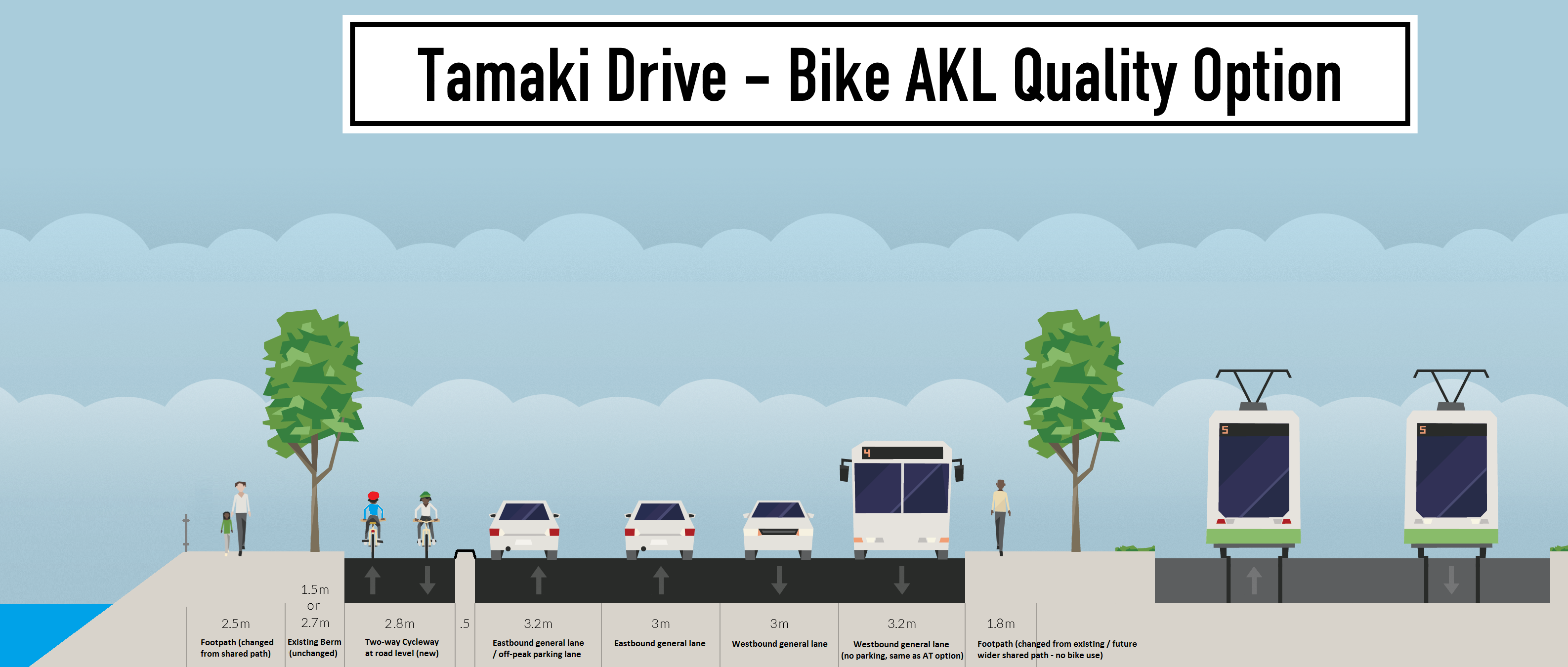
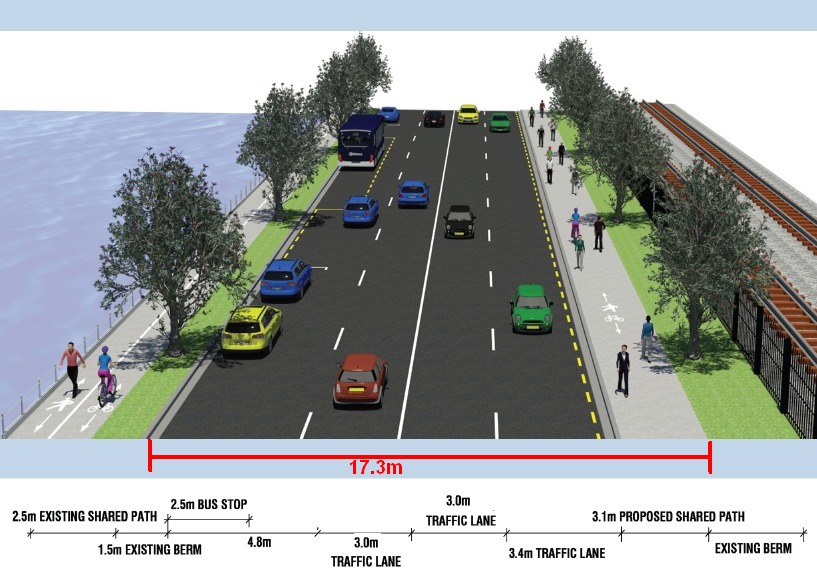
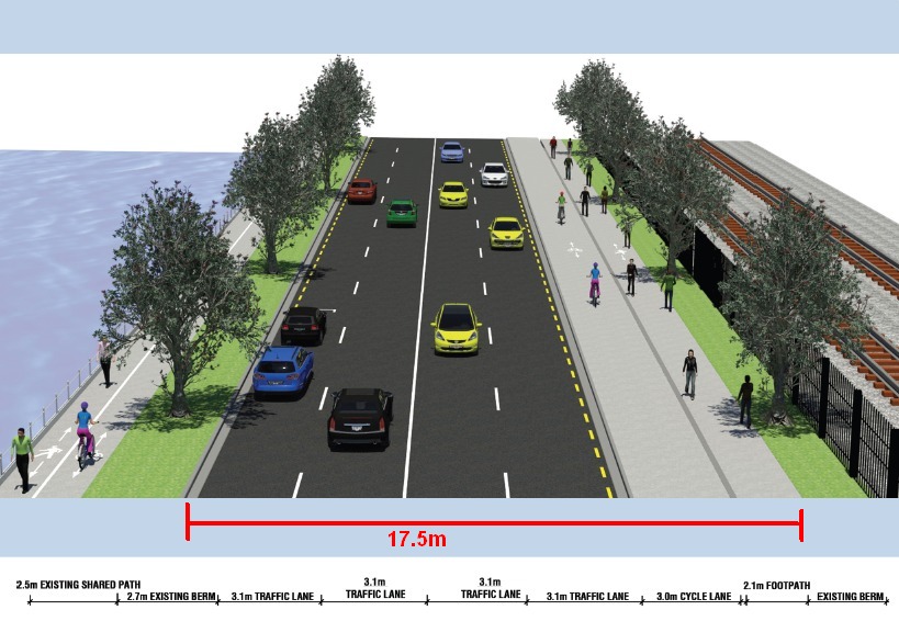
- works within exactly the same road space AT uses in its own design (17.3m west of Parnell Baths and 17.5m east of the Baths)
- ties into current and future plans for cycleways to and along Tamaki Drive
- creates an opportunity for an iconic design statement
Feedback is open until Sunday 18 June. Now’s the time to run over to the project page or the direct feedback page. Let AT know you don’t want their current design, which only improves things at the expense of on-road riders. And ask them to consider the Bike AKL Quality Option instead.
OK. Here’s our proposal… click to enlarge.
Is it doable? We think YES.
How do we do it? The existing shared path on the southern side is used by only about 5% of all current Tamaki Drive cyclists. If we reduce it to a regular footpath of 1.8m, we can use the space to provide a two-way cycleway on the north side of Tamaki Drive, together with a door-zone buffer.
How is this better than the previous designs (including our initial interim option)? Let us count the ways!
- It creates a protected two-way cycleway! On the northern side, which ties in well with existing (Quay Street) and future (Eastern Bays) seaside paths. No need to cross back and forth! Consistency and convenience for our busiest cycleway, easily accommodating its tidal flows into town and out again.
- It works for eastbound on-road riders, and doesn’t actively endanger them! Riders headed to the Eastern Bays can enter and exit the north-side cycleway without having to wait for two sets of cumbersome crossing signals to the south side and back. Plus, they aren’t forced to choose between the narrow old shared path and the lethal on-road door zone of the AT Option.
- It isn’t lethal for westbound roadies, either. Some citybound travellers won’t want to cross over to the sea-side at Ngapipi Road and then swap back to the southern side. That’s fine – because with no car parking and two travel lanes on the south side, those cyclists can stay on the road and claim a lane. And they can do so without forcing drivers to cross the centre line during overtaking manoeuvres – as AT’s option would force them to in the other direction. Better safety, less aggression between riders and drivers!
- Safe, buffered car parking. Like the AT Option, the Bike AKL Quality Option retains car parking on the northern side – but we provide a door zone buffer for the cycleway. This will also help at any bus stops where passengers need to cross the cycleway.
- No more shared paths!!! Here’s where our option really excels: by finally creating dedicated bike and pedestrian space. This is a major win for pedestrians and joggers, who can amble at their own speed on the seaside path (or landside path), without constantly being overtaken too closely or having to give way to bikes. So much nicer, so much safer. And so much fairer – not just to riders, but also to our walking friends!
Something better than a shared path is long overdue (over 40 years overdue!) on our busiest cycle route and most prominent harbour promenade. Let’s stop compromising by squishing bikes and pedestrians into the same space – let’s start doing the right thing!
If our Bike AKL Quality Option is so awesome… why hasn’t AT come up with it already?
In other words, are there any flaws in our clever plan? We wouldn’t call them flaws – which implies problems that can’t be dealt with – but we do see four aspects that Auckland Transport may need to overcome (some with help from Auckland Council and NZTA?) in order to run with our option.
1. The Bike AKL Quality Option only meets the width requirements by a whisker.
You’ll notice our two-way cycleway is 2.8m in the cross-section above. That’s minimum width, so not ideal. There are substantial stretches of the road with enough room for 3m or more – but, like AT, we’ve intentionally focused on the tightest sections of road to make sure everything can fit.
Solution: At particularly narrow points, AT can remove parking spaces as needed and reduce the solid buffer to 0.3m (which is only 0.5m wide because of car doors).
West of Parnell Bridge, the space shrinks by another 0.2m at the tightest point, and a two-way cycleway of 2.6m wide wouldn’t be great.
Solution: It’s tighter here partly because the AT Option adds 0.6-1.0m breathing space for the tree roots on the south side. We feel that for safety of cyclists and a good consistent design, this added width could be flexible. If AT and Council think the added space for the trees would work at 0.4-0.8m, everything else will work even better.
2. The southern shared path will be reduced to 1.8m footpath width.
This is only really a problem if there are underground services close to the surface in the part of the current shared path that becomes a traffic lane.
Solution: Why compromise our busiest cycleway and most prominent seaside road? Of course services can be relocated if needed; every second roading project does this as a matter of course. The AT Option already moves the curb line; our option moves it the other way, with many of the related costs already included in the budget.
3. Over the two bridges, the road space is a lot narrower.
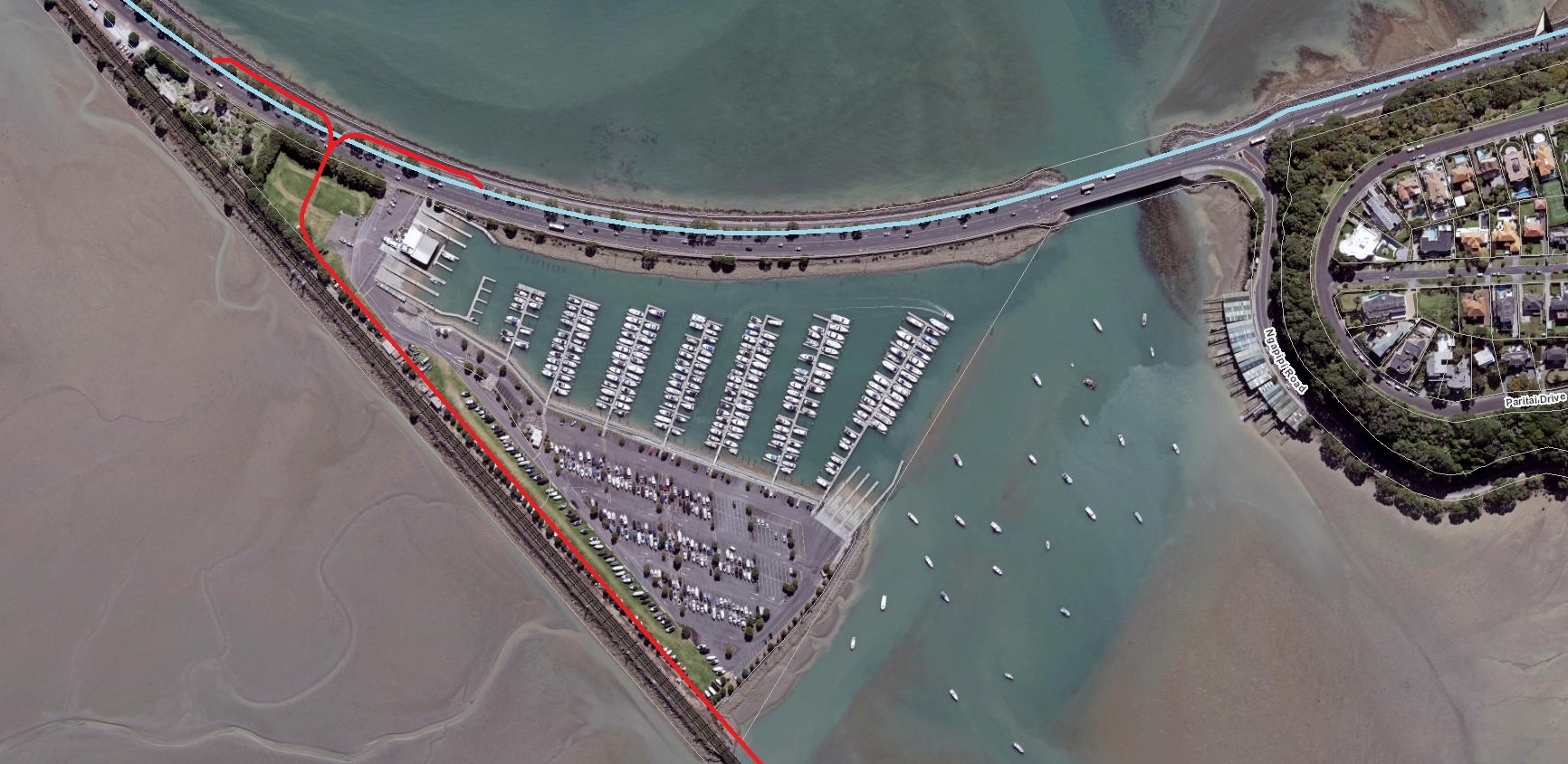
East of Parnell Baths, and just west of Ngapipi Road, two bridges allow water to flow in and out of Hobson Bay. Those bridges have a narrower carriageway, so it isn’t possible to run our proposed cycleway through these sections without significant changes.
Solution: In the short run, we probably need a short section of shared path (ugh, but necessary). As opposed to the AT Option, these shared path sections would be very short. Riders would have to slow down a bit to ramp up onto the shared path across the bridge.
And of course eastbound riders might elect to return to the traffic lane for a short section if they prefer not to go onto a shared path (no parking on the bridges, so no door zone issues here).
In the long run, this option still puts the cycleway in the right spot for future developments. AT is looking at widening the bridge near Ngapipi Road, likely via clip-on(s). The Bike AKL Quality Option means that when funding and design appear for bridge-widening works, the cycleway will already be on the correct side. The southern side is wrong now, and wrong for a future seaside path out around the Bays.
4. The big question: how would the north side cycleway tie in with the Glen Innes Path on the south side of Tamaki Drive?
AT has been doing a lot of work on Stage 4 of the Glen Innes to Tamaki Drive path (GI2TD) – this is the stage that connects Orakei (at the train station end of the Meadowbank Boardwalk) to Tamaki Drive. Providing a safe off-road cycleway option for people to and from the new path is a key reason for this current project – but explicitly not the only reason.
But where will the new path land? To everyone’s frustration, there isn’t yet a confirmed route let alone a design for this crucial section of path that was meant to be completed in 2018. Because a variety of technical issues and complexities around land access via Kiwi Rail and the Outboard Boating Club are still being worked through, the project will likely drift into the next 3-year funding programme, with completion in 2019 at the earliest. Bummer.
The good news: there’s extra time to get Tamaki Drive right. We don’t have to rush ahead with a half-way solution – and in fact, we can afford some big strategic thinking about how GI2TD would connect to a northern-side cycleway on Tamaki Drive.
What options make sense for crossing Tamaki Drive to/from the Glen Innes Path?
Option 1: Cross via signals at Ngapipi Road. The final design for Stage 4 of GI2TD is still in the works, as noted above. But at least one of the short-listed options connects to Tamaki Drive at Ngapipi Road (likely after hugging the Orakei headland on a coastal boardwalk).
For riders from GI, this route to the city would be a smidge longer than just cutting across the bay along the rail line – about 300m – but they would easily be able to cross Tamaki Drive at the brand new Ngapipi Road signals to join the north-side two-way cycleway to town. Simple.
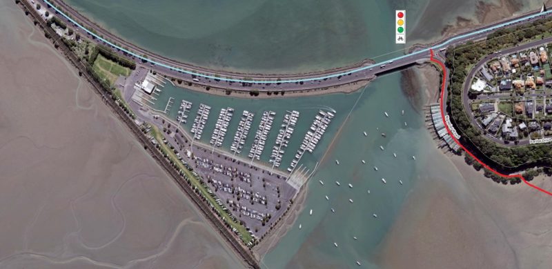
On the other hand, if the GI2TD path were to land west of the Outboard Boating Club instead, GI riders crossing at Ngapipi Rd would have an extra 1.5km of doubling-back – both on the way into town and back home. That wouldn’t work. Which brings us to…
Option 2: Cross at new signals west of the Outboard Boating Club. If GI2TD were to cross Hobson Bay along the railway line, then join Tamaki Drive in the reserve west of the boating club, we’ll need a mid-block traffic signal to get to the northern-side cycleway.
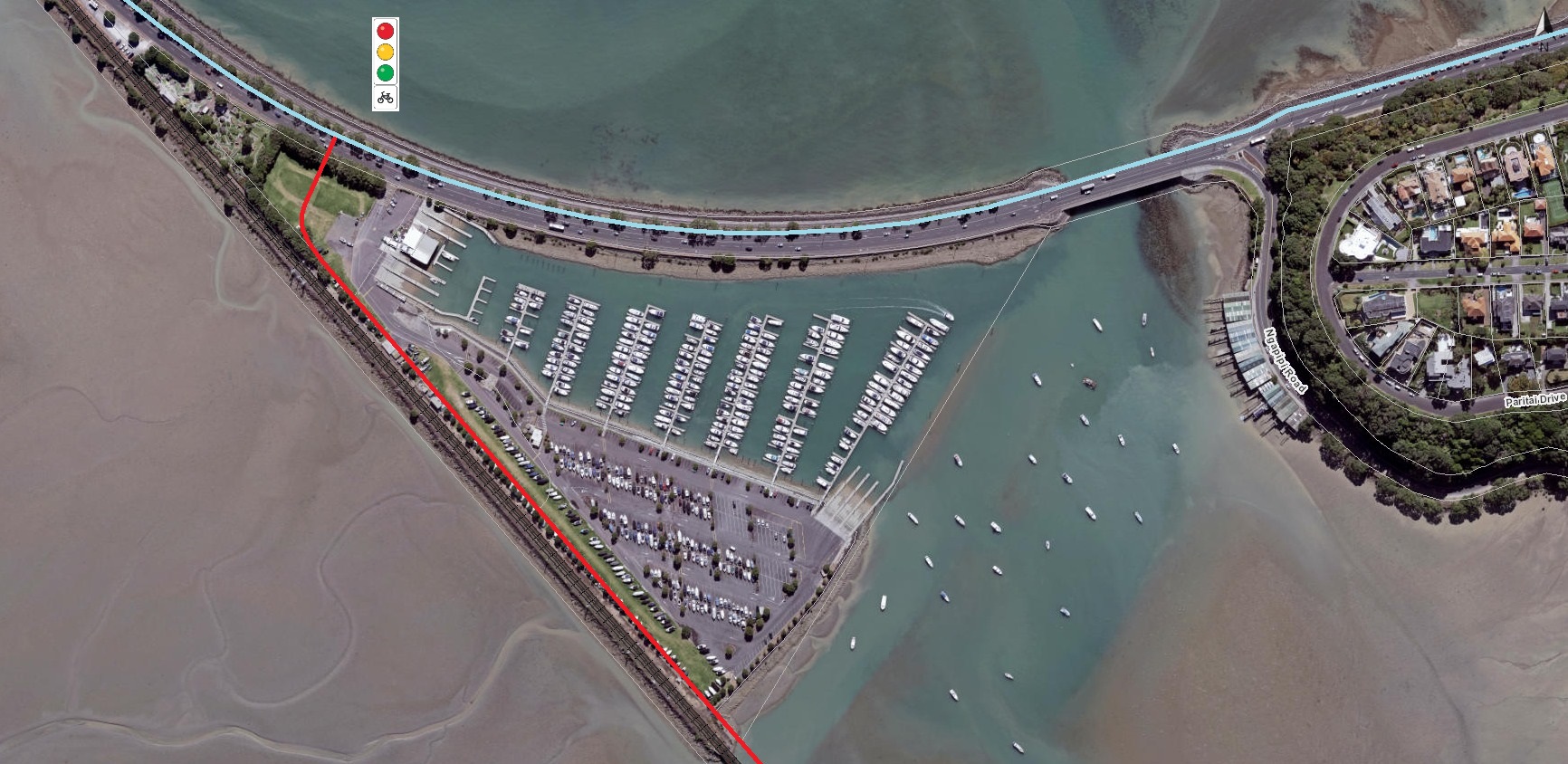
Auckland Transport has previously rejected a mid-block signal, due to concerns about delays for cars (indeed, concerns about traffic signals here appear to be one of the main reasons AT proposed the southern side option in the first place, despite its safety issues for people on bikes).
We think mid-block signals can and should be considered more seriously, and could be coordinated with neighbouring signals to reduce congestion. But this may be a controversial option – and even if it’s adopted, people on bikes might still face a substantial wait to cross the road.
And that brings us to…
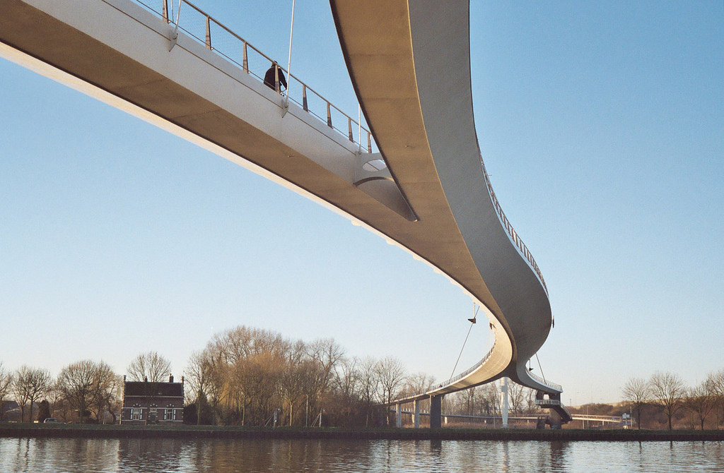
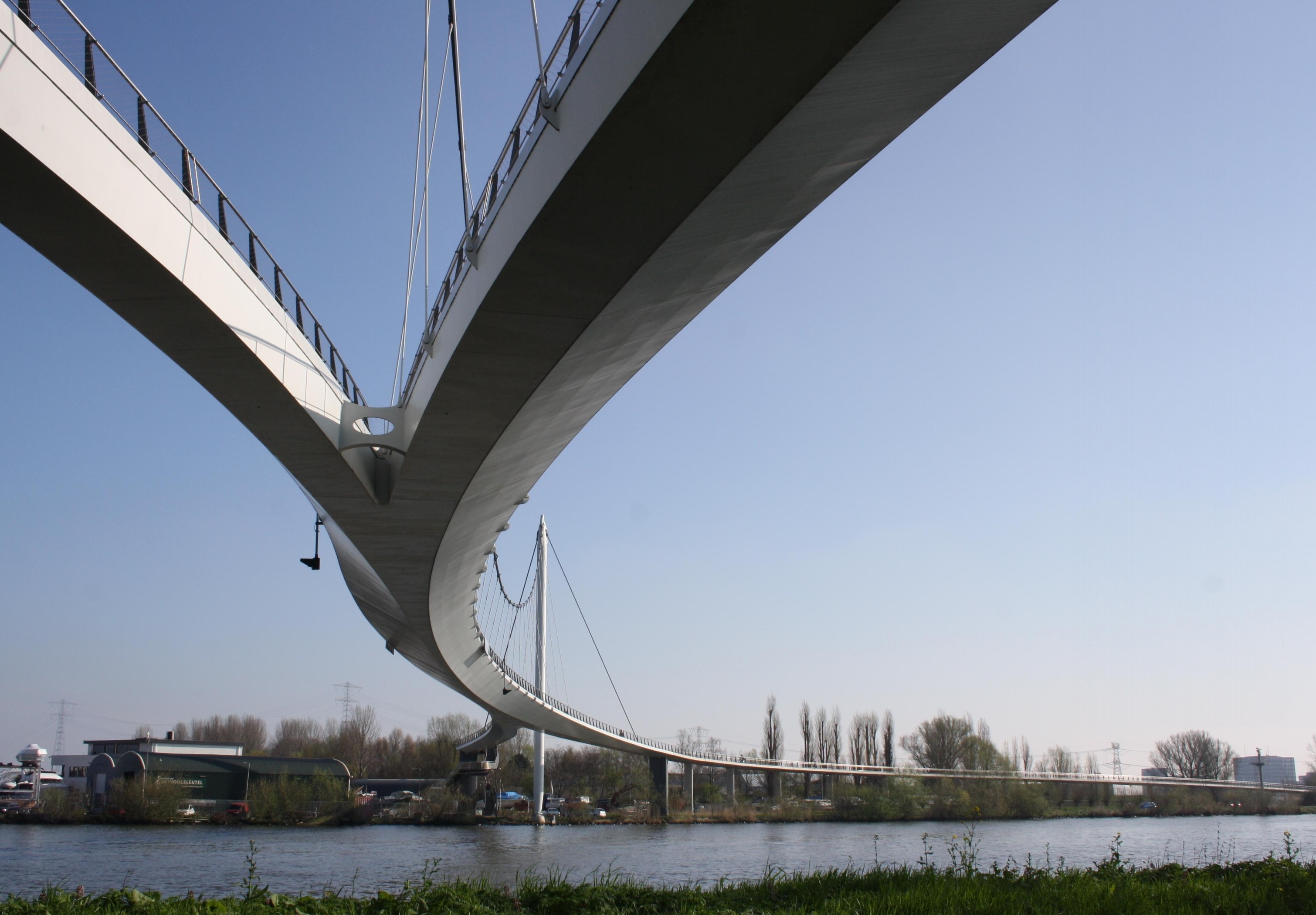
Option 3: An iconic cycle bridge! Here’s where things get really interesting. If the funding can be found, the best solution linking GI2TD to the Bike AKL Quality Option would be a big sweeping bridge over Tamaki Drive.
This would be the least disruptive option for vehicles – and, let’s be fair, also the most convenient and direct one for bikes, assuming the ramps are long and graceful, rather than steep uphill battles.
A bridge over Tamaki Drive would need to have a relatively wide span, and be ~6m or so in height, as Tamaki Drive is an over-dimensional route. As the award-winning nearby Point Resolution Bridge shows, this can be done beautifully and artfully.
If GI2TD lands west of the boat club, it may already be some 3m up in the air, built to travel above the boat storage areas. So any extra climb to cross Tamaki Drive would be minimal, at least for citybound riders. Once up and over the road, the path could then split to allow access westward and eastward to the Tamaki Drive sea-side cycleway.
New Zealand is already becoming known for stunning walking/biking bridges – so why not continue that streak? We really wanted to create a rendering of how such a bridge might look from Tamaki Drive, but it’s hard to get a decent angle, due to the parade of gorgeous pohutukawa at ground level. Luckily, similar bridges have been built elsewhere – especially by the Dutch (no surprise!).
Imagine, for example, if our new Tamaki Drive bridge took its cue from Amsterdam’s Nescio Bridge?
Or how about Copenhagen’s Cykelslangen aka the ‘Bicycle Snake’? (The soundtrack for the video below is ‘Do it right, just do it!’ We like the sound of that!)
No question, a bridge solution would require extra investment (around $5 million would be our guess). That’s not a sum Auckland Transport has in their current budget for this route – so it would need to come from other sources, perhaps a new iteration of the Urban Cycleway Programme.
But think about it: this is our busiest and most iconic cycle route, about to be joined by a hugely significant new cycle route. Shouldn’t we do our best by it – by providing a proper, safe, appealing on-road cycleway on Tamaki Drive, and an iconic intersection of these two major paths worthy of their importance?
That’s the big question: can we elevate our thinking and achieve the best outcome for all?
This is no flight of fancy. This is a serious, smart and workable proposal. In the face of the AT Option which is at once underwhelming and potentially lethal, we issue a friendly challenge: the Bike AKL Quality Option.
Quick – head on over to the project page or the direct feedback page before 18 June. Let AT know you want a protected cycleway – and that you oppose the current design because it’s dangerous. Encourage them to consider the Bike AKL Quality Option. Eyes on the prize!
[Header image of Amsterdam’s Nescio Bridge by thebotster, via Flickr]


