
This is the second part of our look at connections to SkyPath, following on from our recent post on connections on the North Shore side.
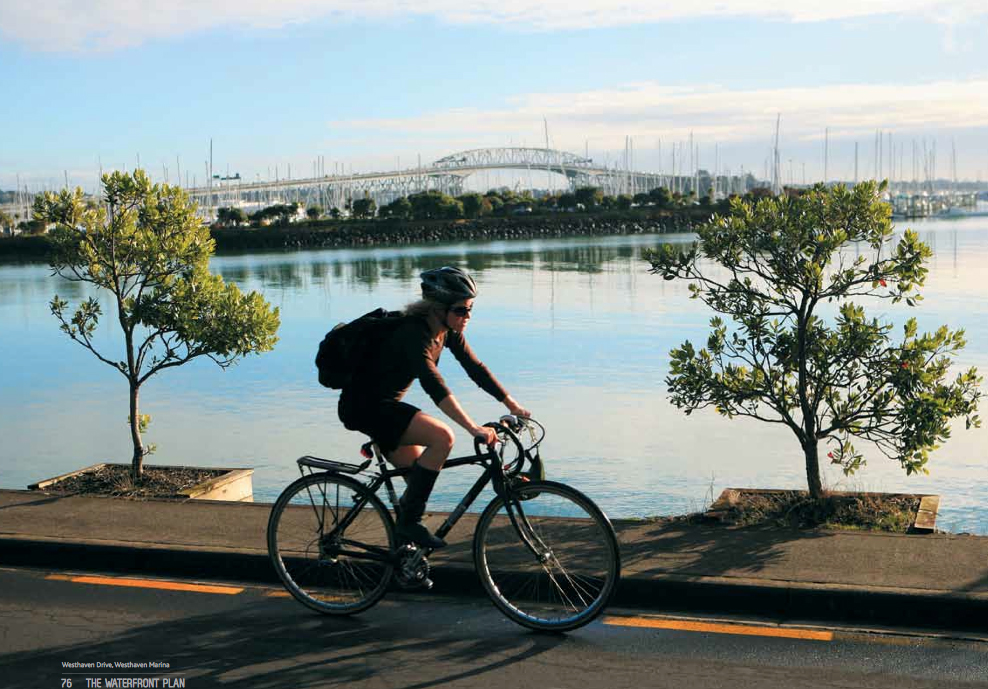
Now let’s have a look at how people will access the southern entrance to SkyPath at Westhaven. The access picture is rather different on the city-side than it is on the north, thanks to great cycling and shared space initiatives which are already underway. These deliver users right to SkyPath’s main entrance from the city centre via Wynyard Quarter using the grand Daldy St Linear Park or the the North Wharf shared space, the Beaumont St separated cycleways, and finally the fabulous new Westhaven promenade off road shared path and boardwalk.
This chain of standout new facilities will work in synergy with SkyPath itself to transform walking and cycling connections on Auckland’s waterfront. It’s hugely positive to see that Auckland Transport and Waterfront Auckland both seem to be grasping the importance of integrating these improvements with SkyPath. These facilities will work together to provide an urban waterfront that Aucklanders can be proud of, with access to the Waitemata Harbour, the waterfront, parks, facilities and wonderful cafes and restaurants. And, it also has a completely level gradient.
With these inspiring and transformational city walking and cycling links in place, it’s reasonable to argue that many people won’t need to drive to access SkyPath – in itself, this is a new paradigm for Aucklanders, and one that fits completely with the goal of a 70-30 modal split for Wynyard Quarter (i.e., 70% of trips made by non-car trips ).
“…Over 3000 workers and up to 2000 residents are expected to be living and working in the central area of Wynyard Quarter in the next 10 years…(by) 2030, travel demand within Wynyard Quarter will be comparable to an Auckland CBD environment.

Wynyard Quarter’s geographical location, bordered by water on three sides mean that there will be limited capacity in the future to cater for travel by private vehicles…
A large part of the City Centre including Britomart is 3km or less from SkyPath, so these seamless connections will make SkyPath very accessible from the CBD by bicycle or even on foot, comfortably within range even for even for the round trip that tourists and recreational cyclists are likely to do. It seems obvious that bicycle hire and/or share schemes will be thrive here as in so many other international cities.
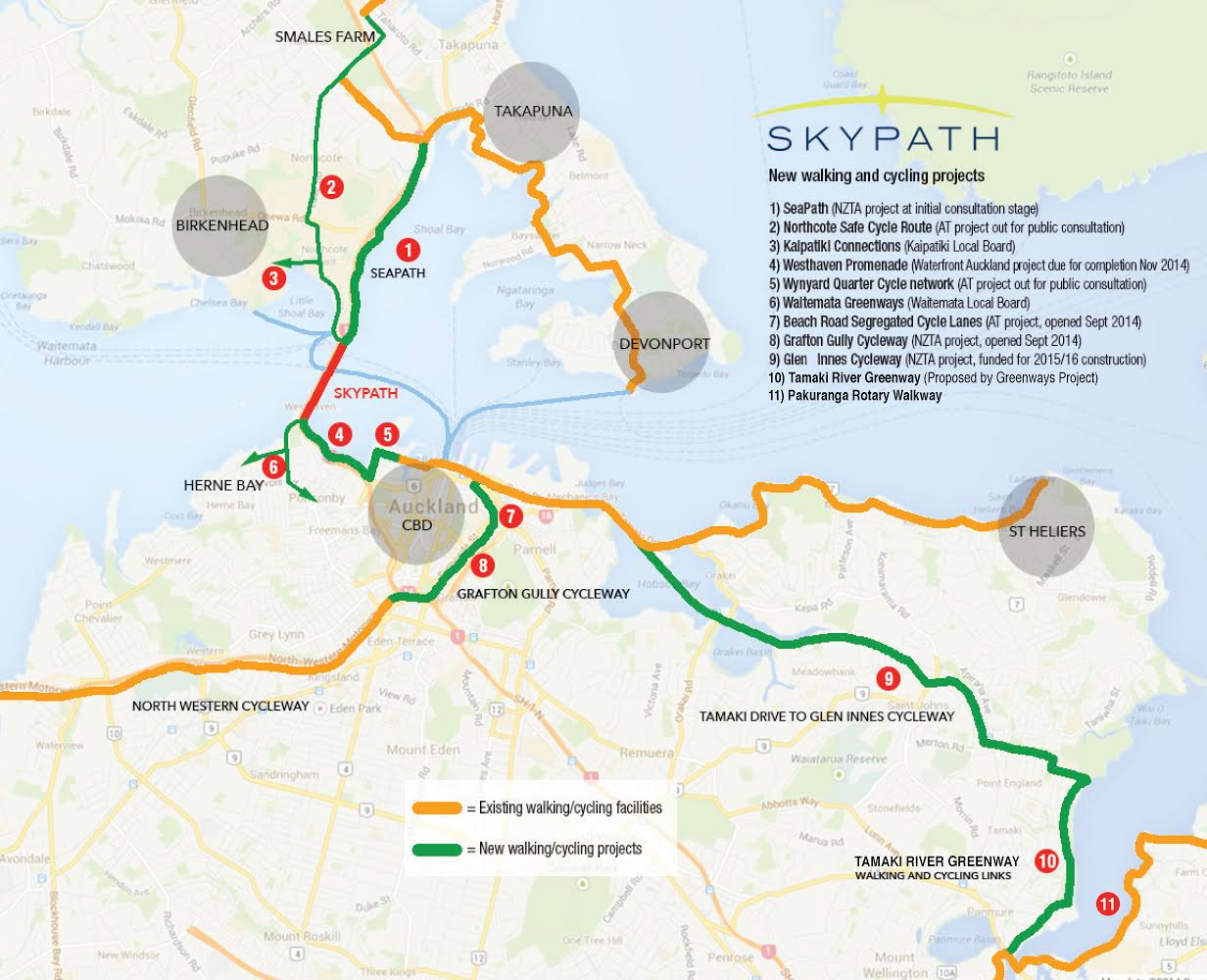
Before we discuss these immediate connections to the city and also to other suburbs to the west and south in more detail, let’s also take a moment to look at the wider picture of SkyPath’s role as a critical link for many of Auckland’s other great cycling initiatives. This diagram from the AHBP Trust (the people behind SkyPath), shows how SkyPath will provide the link that creates a waterfront harbour loop, but also works with other cycling infrastructure to provide region wide benefits (keen eyes may spot some small inconsistencies in this map – but it’s spot on in capturing the vision of Auckland-wide links between cycling connections already in place, about to happen, or on the table as likely.)
Getting to SkyPath’s Main Entrance, Westhaven
By the time SkyPath opens, strong waterfront connections for walkers and cyclists will already be in place – to the city centre at least.
A linked series of international quality urban infrastructure includes the new Waterfront Promenade through Westhaven Marina, which will connect to separated cycle paths on Beaumont St, and through Daldy St Park or North Wharf to the CBD.
Connections from SkyPath to the City Centre
Cyclists will have two options right from the main entrance of SkyPath. The wonderful new Waterfront Promenade is likely to be the primary route and the most attractive option for the majority of recreational cyclists and walkers.
The Promenade is a shared path with boardwalk sections over the harbour and marina that will be a great attraction in its own right but also provide a seamless connection for walkers and cyclists through to the Wynyard Quarter and city centre. The Promenade will suit slower speed recreational and tourist cyclists.
The second option is to use Westhaven Drive, a low speed road, with a 30kph speed limit, which is already used by many on-road cyclists. It’s likely to the access route of choice for commuter and sports cyclists heading to and from SkyPath.
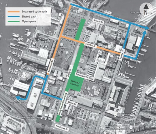
Even better, both options through Westhaven integrate with the new separated cycleways on Beaumont St and Madden St, the main north-south cycling route of Wynyard Quarter, and the Daldy St Linear Park. Daldy St will provide walkways, cycleways, and a slow speed road environment, and will eventually provide a continuous green link from Victoria Park to the tip of the Future Headland Park planned for Wynyard Point. The Wynyard Crossing walking/cycling bridge through to Te Wero Island takes cyclists onto the Quay St footpath (which lacks specific cycle facilities – this short discontinuity needs to be resolved) and through to Britomart. The Quay St shared path then provides a means of continuing on to Tamaki Drive along the waterfront or accessing the Beach Rd and Grafton Gully cycleways.
It’s good to see that both Waterfront Auckland and Auckland Transport recognise the importance of linking SkyPath with these facilities to the city and the eastern waterfront. We’ve previously reported Auckland Transport’s vision:
…the vision is to provide a world-class facility connecting the North Shore (via SkyPath), Herne Bay, and Ponsonby, with the CBD and Tamaki Drive.
Separated cycle paths will go along Beaumont Street and Madden Street.
A shared pedestrian and cycle path will go along Westhaven Drive and the western end of Gaunt Street to Daldy Street, where it will connect with the Daldy Street Linear Park…”.
It’s clear that the fine detail of some of these connections being provided by different agencies – SkyPath, Waterfront Auckland, and Auckland Transport – will be critical to their success. There are several points that need careful
integration (for instance, we’re keen to see how the SkyPath main entrance, under the Auckland Harbour Bridge, connects to the beginning of the Waterfront Promenade) But we won’t look at too much of this detail in this post – we’ll wait to discuss these issues in more depth when there is more information available from the SkyPath Resource Conset. We’re hopeful that the detail of transitions between all these facilities will be completed with a process of refinement with Waterfront Auckland, Auckland Transport, and importantly with stakeholders.
Heading West and South
Curran St and Sarsfield St to Jervois Rd and western suburbs
Not all cyclists will come from the city centre – connections to adjacent suburbs of St Mary’s Bay, Ponsonby, Herne Bay, and suburbs further afield to the west and south will also be critical. Heading west of the Harbour Bridge, most cyclists use Curran St, which is a 30kph slow speed road – before joining the shared path which heads up adjacent to Curran St to the intersection with Sarsfield St. Transitions at both ends of this shared path are currently dangerous for cyclists, especially at the intersection of Curran St and Sarsfield St. These are issues we’ll expect Auckland Transport to be sorting out, as Curran St is indicated as a significant route on the Auckland Cycle Network. While it’s not clear when this will happen, it’s likely that the activity generated by SkyPath may help advance planned improvements to the beautiful but rather exposed and neglected coastal park to the west of the Harbour Bridge, and we’ll expect to see high quality cycling as part of these improvements.
While Sarsfield St is already a natural and popular route for cyclists through to the west, Curran St itself is not cycle friendly – it’s steep, has a high volume of fast vehicle traffic. We hope to see investigation of better facilities on this direct connection to Jervois Rd.
Cyclists from further afield western suburbs will also have the option of using the Northwestern Cycleway and Grafton Gully Cycleway to the city and using waterfront facilities to access SkyPath.
Jacobs Ladder Bridge
Another option linking St Mary’s Bay and Ponsonby to Westhaven is the Jacobs Ladder Bridge walking and cycling overbridge which crosses the SH1 motorway. Cyclists are allowed on the bridge, but need to use an elevator at the north end, as only the southern side access provides a ramp. Cyclists also have the option on using suburban and city streets on road – generally, these don’t offer much in the way of cycling infrastructure.
Waitemata Local Board Greenways
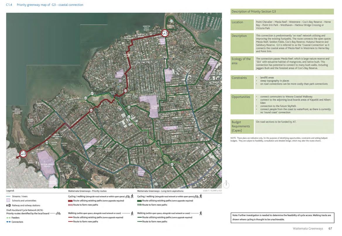
The Waitemata Local Board’s Waitemata Greenways study identifies many existing and priority routes which will connect with SkyPath. This map gives an overview of their priority walking and cycling connections, which give an overview of the accessibility of Skypath from the western suburbs.
Wider connections
SkyPath also forges a major link connecting existing and planned major cycle facilities beyond the immediate waterfront. The southern harbour edge connections we’ve already discussed will connect with Quay St and to the well-established cycling route along the waterfront to the east to St Heliers. Tamaki Drive is already one of the most cycling popular routes in Auckland, used by all types of cyclists, either on the footpath or on road. Not only will this Tamaki Drive connection bring to life the vision of a waterfront loop connection showcasing Auckland’s city waterfront, but it will tie in with the new premier cycle facility Tamaki to Glen Innes Cycleway.
In addition, connections from the city centre through the new Beach Rd facility to the Grafton Gully Cycleway and Northwestern cycleway will provide safe, high quality cycle facilities for access from much further afield.
In conclusion – Do these routes meet the needs of SkyPath users?
We know from the independent research that are most SkyPath users are likely to be recreational walkers and cyclists, both Aucklanders and visitors to Auckland, many of whom will want to access SkyPath from the CBD and then complete a round trip loop. These users will enjoy the experience of safe, connected high-class facilities along the waterfront to SkyPath, suitable for recreational cyclists of all kinds including families, visitors and tourists.
Commuter cyclists will be fewer in number, but will be regular users of SkyPath and play an important part in achieving a growing mode shift away from private vehicles over the AHB. At weekday peaks, commuter cyclists will want safe, flexible, connections to and from SkyPath and the Wynyard Quarter, the city centre and further afield. The better these connections are for cycle commuters, the more impact SkyPath will have in contributing to a peak hour modal shift towards active modes which will really change the paradigm of Aucklanders’ expectations for travel around the city centre and waterfront.


