
Auckland Transport is proposing a light-controlled pedestrian and bike crossing on Te Atatu Road, to upgrade a dangerous crossing point near where a fatality happened in late 2017. While this would be some improvement on the status quo, does it go far enough in ensuring safety?
Not to our eyes. Here’s the project page and here’s the proposed design: AT proposal for Te Atatu Rd signalised mid-block crossing. At the absolute minimum, we would recommend AT retain a central island, narrow the traffic lanes, and add some kind of threshold treatment to reduce the perceived width for drivers here – instead of increasing it by removing the existing island. This would improve actual and perceived safety for people crossing the road here, given the enormous width of the road, and especially as we know Auckland drivers tend to disregard or blow through red rights, which is particularly a risk at mid-block crossings away from intersections.
But there’s an even better solution. Below, Carol Green on behalf of Bike Te Atatu lays out a vision for an even smarter, safer crossing here, one that addresses local usage and improves cycling connectivity. Bike Auckland wholeheartedly supports this call.
Please use the AT feedback form before Monday October 15 to support the Bike Te Atatu Vision laid out below.
Ask Auckland Transport for these three things:
1. Please investigate and respond to the Bike Te Atatu proposal to move the crossing and reduce northbound lanes.
2. If it turns out none of the Bike Te Atatu proposal can be implemented: please at least improve the proposed crossing design by narrowing lanes, adding threshold treatments and a central island, and lowering the speed limit here. This will set a Vision Zero standard for future similar examples.
3. Please extend the deadline for submissions, given the importance of this safety fix. The current consultation period coincides with school holidays, which means many affected people will either be out of town or will have their hands full entertaining the wee ones.
The case for a smarter, safer crossing
–by Carol Green, for Bike Te Atatu
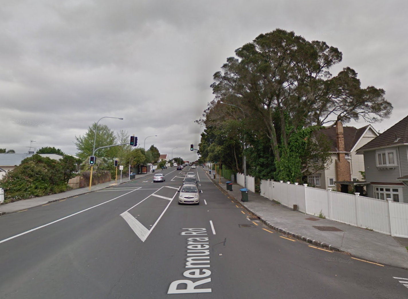
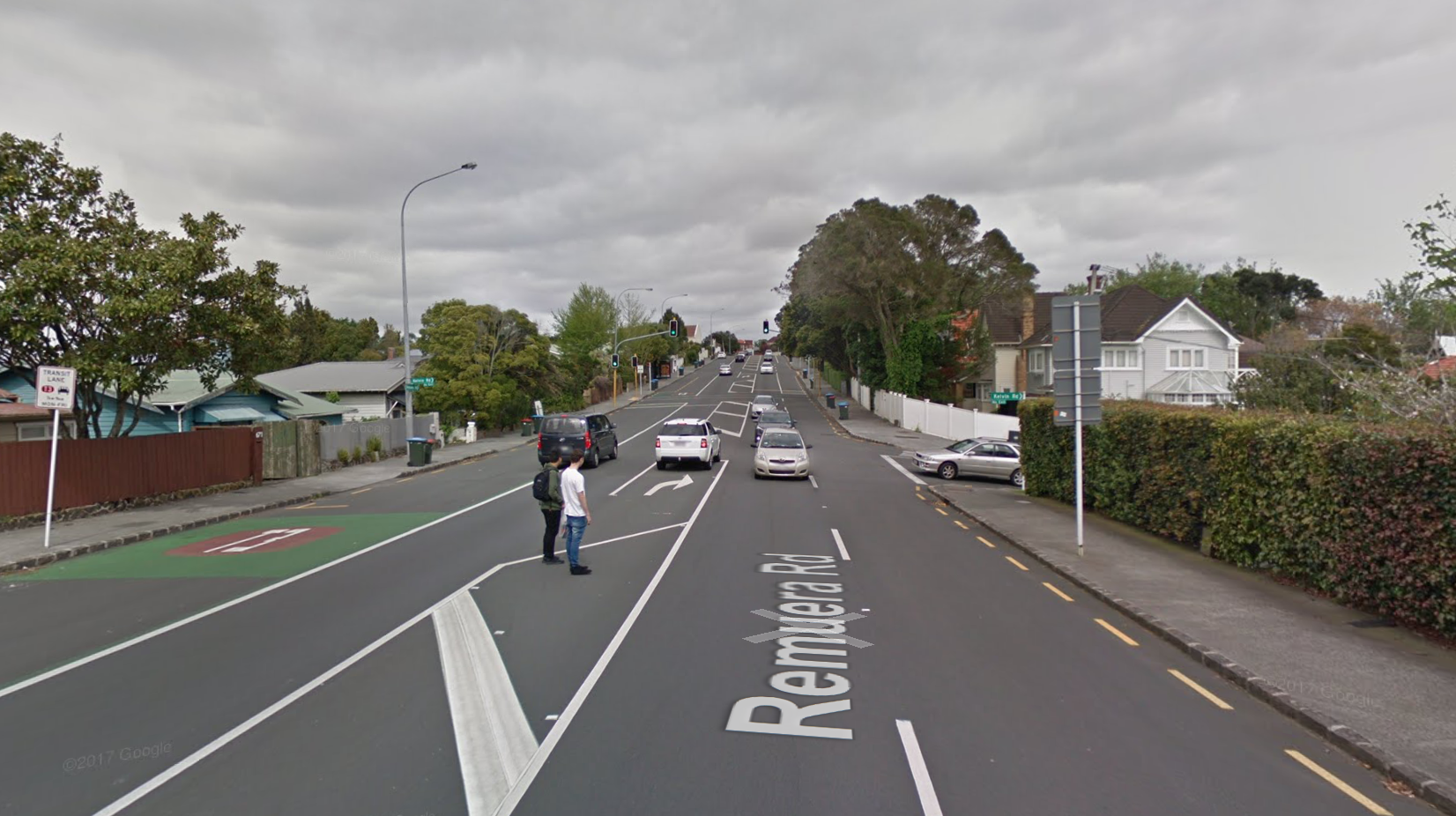
In response to community concerns, and as part of its minor safety improvements budget, AT is proposing to replace an existing pedestrian refuge outside 477 Te Atatu Road with a mid-block light-controlled pedestrian and cycle crossing. As proposed, AT says it would look a bit like this example on four-lane Remuera Road, albeit with bike crossing markings added. While any improvement on the status quo is welcome, we don’t feel this design goes far enough in ensuring safety and access.
The local context
In Te Atatu Peninsula, we are very lucky to have the Northwestern Cycleway providing really good bicycle access to the city and further west. Our connection to the NW cycleway is via a cycle path along the edge of Harbourview Park – beside the very busy Te Atatu Road, that pours traffic in and out of the peninsula in tidal flows, morning and evening. It’s the only road in and out of the peninsula.
At the northern end of Harbourview Park, the cycle path comes to an abrupt end. Northbound cyclists are then expected to cross four lanes of busy traffic to join the painted cycle lane on the other side. Local walking access to Harbourview Park – a destination in itself, host to Kite Day and other large events – is also mainly across this busy road.
AT’s latest traffic count for the stretch between the Gloria Ave roundabout and Cellarmans St shows an average daily total of 24,218 vehicles through here, with 2000+ vehicles per hour at peak.
There is a pedestrian refuge at this point on Te Atatu Road – locally dubbed the ‘pedestrian jail’, on account of the metal corral, and the time spent trapped in it. The constant flow of traffic at some times of the day means that it can take a good two or three minutes to cross the road here. I regularly see parents crossing here clutching toddlers, pushchairs and balance bikes, on the way to and from the park. (I also hear people in the community describe giving up and driving to this local park, because getting to it on foot or on two wheels is so stressful.)
Here’s a video taken looking south from the ‘pedestrian jail’. You can see how constant the traffic is, how few incentives there are for drivers to make space for pedestrians or people on bikes crossing here, and how difficult it would be for any one but active adults to negotiate safe passage.
So why do people cross here, even though it’s so hostile? Because the nearest ‘safe’ (light-controlled or zebra) crossings to this ‘pedestrian jail’ are 600m in each direction. That’s a 10-20 minute detour for the average person, and likely longer for much younger or older people, or anyone with disabilities or wrangling small children.
Along this stretch, Te Atatu Road is built like a motorway: four lanes wide and dead straight, with a wide painted median strip. Despite having a digital speed display alerting drivers to how fast they’re going, speeds along here regularly exceed 60kph, and fences and walls are regularly taken out by speeding traffic.
The existing pedestrian refuge is also a few metres south of where John Bonner was killed in December.

All of this is why the community has been crying out for change, for years before the tragedy last Christmas, and even more strongly since. The Te Atatu Peninsula community – whether we drive, take buses, ride bikes, and walk – are all passionate about resolving the safety issues. This stretch of road is used by 80% of residents coming in or out of the peninsula (using any mode of transport), so we all have opinions about what should happen here. We all see people struggling to cross this road, we all make use of Harbourview Park, and we were all affected by the death of John Bonner. We want to help Auckland Transport do the right thing here and do it well.
Given Auckland Transport’s decision to prioritise road safety, this could be a great test case for some Vision Zero thinking. Unfortunately, our belief is that the quick fix AT is currently proposing won’t fully address the dangers here. Fortunately, we have a suggestion, informed by local knowledge and experience, that will.

What Te Atatu needs in a crossing
Firstly, as suggested by Bike Auckland, if the crossing goes in at this location, it would absolutely need to keep a central traffic island and include some kind of threshold treatment to narrow the traffic lanes and alert drivers to the fact they will need to be prepared to stop. This is the reality of our lived experiences of Te Atatu Road. We especially want to see slower speeds here.
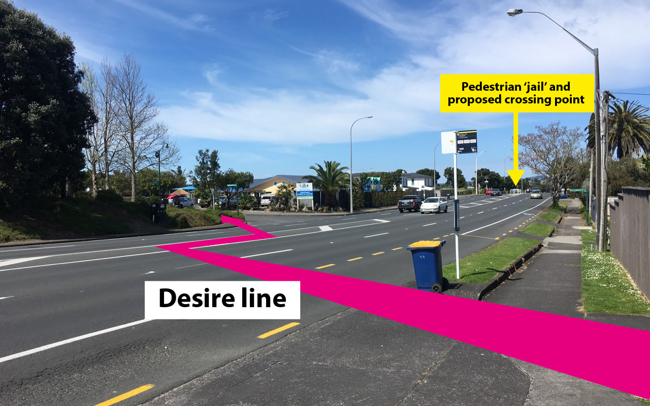
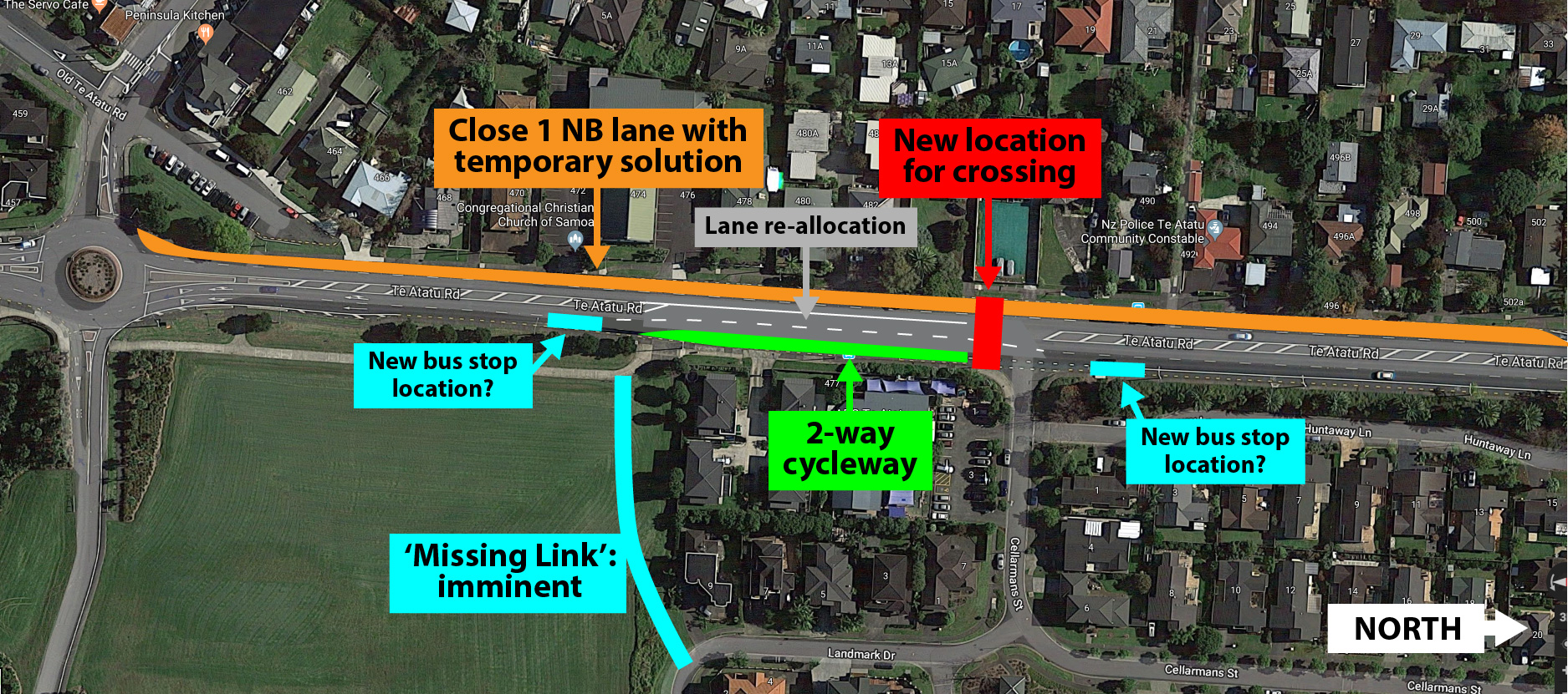
But there’s more we think AT needs to understand about how people use this stretch of road. This is the current situation, with the yellow label showing the current ‘pedestrian jail’ where the new crossing would go.
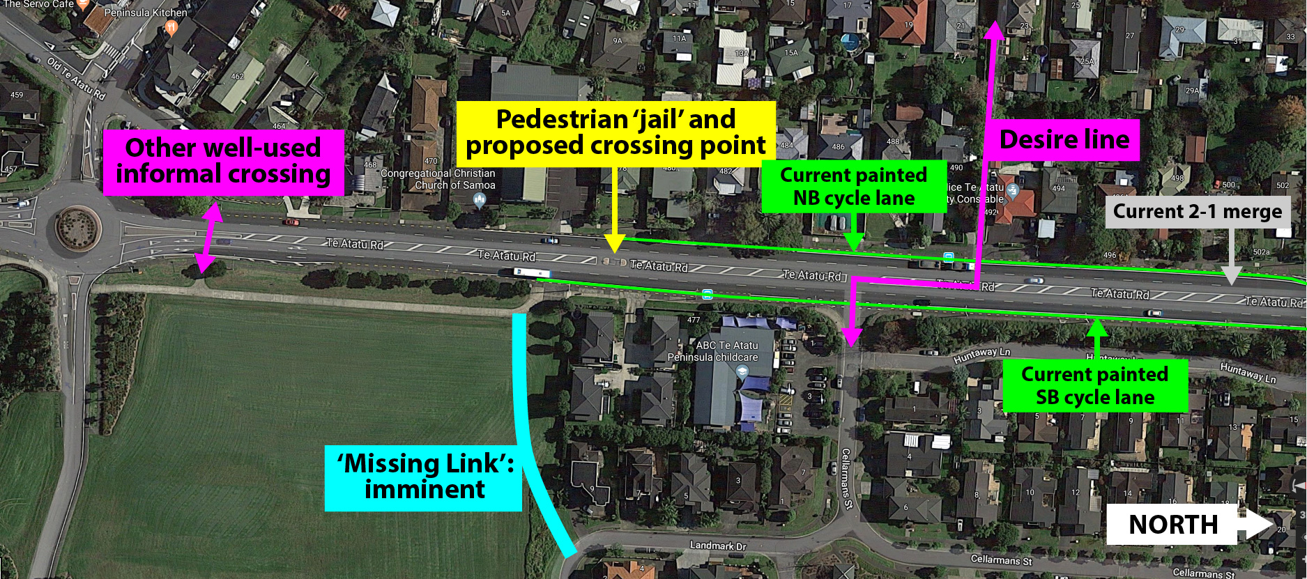
Firstly, note the existing desire line, which is well-used by people walking and biking, connecting the alleyway through from Graham Ave, across Te Atatu Road, to Cellarmans St. The attractors here include a homeward-bound bus stop on Te Atatu Road, a daycare just inside Cellarmans, the houses here (who share just the one street entrance on the main road), and ultimately the park.
Rather than detour to the pedestrian refuge (~200m + the waiting time in ‘jail’) to cross Te Atatu Road, most foot traffic here chooses to use the central median to make a 2-stage crossing across the 4 lanes. This often involves dashing through gaps in traffic.
It’s also a desire line for people on bikes heading homeward, who have to find a way to get from the parkside cycleway to the northbound bike lane. The ‘pedestrian jail’ is a tricky thing to negotiate on a bike, so many people will instead cross slightly north of that refuge spot, using the median strip as a breathing space while waiting for a gap in traffic.
AT has previously recognised this desire line by adding a pram ramp at this spot on both sides of this hostile road, so they must have some record of people’s movements here. And, just as people using this common desire line don’t detour to the pedestrian refuge 100m south, they would be unlikely to detour to the proposed new crossing – and would likely continue to risk the mid-block crossing.
Another well-used crossing point to the park is the pedestrian refuge just north of the roundabout. Here, two lanes of fast-moving traffic exit the roundabout, which makes crossing here much less predictable, very difficult to judge, and almost impossible for kids.
Watch this video, shot from a kid perspective. Think you see a gap in the traffic you could make a dash through? Wait until the end.
While this is a hostile crossing, we don’t expect people who currently cross here would make the 150m detour via the proposed new crossing, and will likely continue to cross here to access the park entrance. (And to be honest, this roundabout is a much larger safety and access problem for all road users that the current fix cannot solve.)
Overall, those double northbound lanes compound the danger along this entire stretch. Having two full lanes of traffic heading north through this residential section just doubles down on the ‘motorway’ feeling, making it much more difficult and risky to cross the road (and leading to the demise of walls and fences). Then, some 400m north of the roundabout, the two lanes merge into one lane (on the far right of the above diagram), creating a nasty pinch-point for northbound cyclists at the merge point. This whole piece of road needs rethinking.
What we propose instead
Thanks to longtime Bike Te Atatu stalwart Bryce Pearce, who has been thinking about this problem for many years and pressing AT for a solution, we have a proposal that incorporates local experience and, we believe, would significantly improve both safety and access for people walking and biking.
1. Firstly, we would like to see the proposed signalised crossing moved approximately 75m north towards Cellarmans St. This would provide a much more logical crossing point for the many pedestrians travelling the desire line between Graham to Cellarmans, as well as a safe crossing point for homeward-bound cyclists to access the northbound on-road bike lane and the western side of the peninsula.
Would the signals incorporate Cellarmans St itself? Perhaps – this would be for Auckland Transport to investigate. As well as making things safer for walking and biking, this would allow for safer entry and exit into Cellarmans by people in cars, which would surely be a benefit.
This move does mean some extra thought would need to be put into addressing the short gap between the end of the current cycleway and our proposed crossing. While ‘The Missing Link’ path (thanks, Henderson-Massey Local Board!) will provide an alternative route into the peninsula’s eastern streets – useful to residents and intermediate school children from Harbourview/east-of-Beach-Rd and intermediate school children coming from Te Atatu South – it still won’t solve the need for a safe connection for people on bikes who are heading north and north-west from where the park-side cycleway ends. So…
2. To address the cycleway gap, create a 2-way cycleway along that 75m stretch, as far as the new crossing location.
There’s only one driveway to negotiate in this section. There is, however, a bus stop, which already cuts into the existing cycleway. This would preferably be moved ~100m north, i.e. just north of our proposed crossing location, where it would match up with the existing stop on the other side of the road. (It could also shift slightly south of its current position, but there it would service slightly fewer houses here, and be further from a safe crossing).
3. To improve safety overall – especially given the existing risk to people and to properties – rethink those two northbound traffic lanes from the Gloria Ave roundabout. The left-hand lane through the roundabout could be reserved for left turns only into Gloria Ave, and the right-hand lane for straight ahead and right turns only. North of Gloria Ave, the left-hand lane could be closed off with low-cost paint and hit posts (as a tactical safety project) as far as the current merge point.
If AT is concerned about traffic flow here (which they shouldn’t be prioritising above safety anyway), a tactical approach could be a good test before permanent solutions are rolled out in the future.
The bigger picture
All of this should also be seen against the much wider backdrop, as this local fix is just one part of the big picture.
• AT has just committed to Vision Zero and this giant road creating dangerous severance through a residential area needs to go on a diet.
• Te Atatu Peninsula is scheduled for intensification under the Unitary Plan, with potentially 3000-4000 new residents in the next 20 years.
• Harbourview-Orangihina Park is scheduled for changes and improvements designed to increase local usage of the park – and we can’t all drive and park there! Walking and biking has to be a safe and meaningful option for residents.
• The wider traffic challenges for Te Atatu North – a one-way-in, one-way-out peninsula, with no dedicated busway on SH16 – are not going away until there’s a viable public transport alternative (light rail?).
• There’s a massive rise in people choosing to commute by bike, boosted by the improvements to the NW cycleway and by the ongoing boom in e-bikes making the trip more thinkable for more sorts of people. These people deserve a safe and continuous connection to the cycleway.
• Local bike use by school kids and adults alike is on the rise and will continue to add to everyday bike traffic on the peninsula.
• Safer streets for those walking and on wheels will be safer for everyone in this close-knit community. Nobody wants to be on either end of another tragic crash.
• What Auckland Transport delivers here could be exemplary for other places across Auckland where motorways meet local streets and urgent fixes are needed.
Also, John Bonner died here – let’s honour his memory and do this right.
–Carol Green, for Bike Te Atatu (Follow us on Facebook and Twitter)
Use the feedback button to ask AT to:
1. Please investigate and respond to the Bike Te Atatu proposal.
2. Please at least improve the proposed crossing design in line with Bike Auckland and Bike Te Atatu’s suggestions.
3. Please extend the deadline for submissions to beyond the school holidays.


