

Heads up: consultation closes Sunday 19 April on the Northern Pathway Phase 1: Westhaven to Akoranga (aka the pathway formerly known as Skypath and Seapath).
You may be thinking “what, again?” We can assure you, this isn’t yet another restart of the project. It’s a refinement as we get closer to construction – and a chance to comment on NZTA’s newest thinking.
The feedback survey asks two simple questions. Here’s what we suggest mentioning in your answers – feel free to use your own words and explain what the path and its features will mean for you. For more detailed analysis, scroll further down the page.
And remember, you have until 11.59pm on Sunday 19 April to add your voice to the chorus!
- What do you like about the Northern Pathway design, and why?
- The continuous 4.6km of pathway linking the city to the Shore
- The increased width, to 5m over the harbour bridge and 4m along the Northern Motorway
- Underpasses/overpasses for ease and safety, to avoid intersections and crossings
- Access on and off the path at multiple points
- The idea of being able to use it 24 hours a day and 7 days a week!
- How do you think we could improve about this design, and why?
- Please ensure a seamless connection to Phase 2 of the Pathway (Akoranga to Constellation)
- Provide separation between pedestrians and cyclists wherever possible
- Add a connection to Exmouth Road in Northcote
- Upgrade the connections across the motorway at Esmonde Road for people accessing the path from Devonport and Takapuna
- Love to see some artistic design work for bridges and major structures
So what’s new? Let’s take a look at the details…
Since the last consultation in September 2019 on lifts vs. ramps, NZTA has been very busy in the background refining designs for the Harbour Bridge section that we saw last year, as well as negotiating with property owners, reviewing path options, and getting their business case approved.
In short: Northern Pathway (Phase 1) will deliver a continuous path from Westhaven to Esmonde Road, which will be 5m wide over the bridge and 4m wide nearly all the rest of the way – and proposed to be available for use 24 hours a day, 7 days a week.
This consultation asks you to consider some fresh design thinking at various connections, as well as how you feel about the overall project. Below, we take a look at the details, from south to north, from city to shore. Any questions, or if you think we’ve missed anything, give us a shout in the comments below.
Click to enlarge the map below, or you can download the PDF version here: NZTA Northern Pathway Shared Path Map – April 2020 or see a more detailed map online.
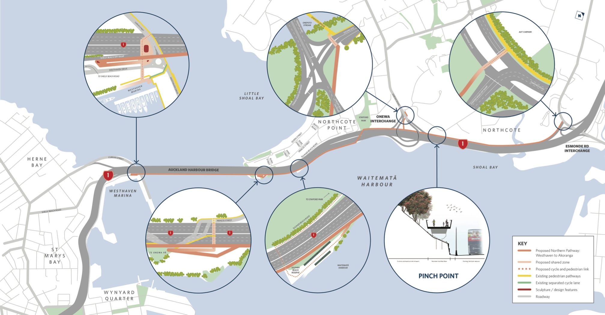
Westhaven Landing
The design for the ramp on the central city side is largely unchanged from designs circulated at the end of 2019. This part of the project connects via a small plaza under the harbour bridge, to Curran Street and Ponsonby, and to the Westhaven Promenade, which follows Westhaven Drive to the central city.

It’s worth noting that both the Northern Pathway and its landing ramps are designed to be 5m wide – which means the “hairpin” turn on the ramp will be more than 10 metres across. This is a lot more space than we’re used to (with 3-3.5 metre shared paths producing a turn space that’s 6-7 metres across). Even so, with pedestrians in the mix, it will be important to maximise this space as much as possible – for example, by ensuring railings and so on don’t block visibility.

The Auckland Harbour Bridge
The path over the bridge remains unchanged from previous renderings. The 5m wide path continues up and over the water at roughly road deck level, with a widened viewing platform each side of the centre span.
Due to the design of the Auckland Harbour Bridge itself, the need to allow for tall traffic under the bridge, and the new path being attached directly to the pillars rather than clipped on to the clip-on, this centre section has become one of the longer single-span dedicated walking and cycling bridges in the southern hemisphere.
One thing that’s still undecided is whether the path will be a shared path, or have some separation between walking and cycling. We feel that with 5m width on the bridge at least, some form of “soft separation” should be considered: e.g. advice for where people should go, supported by markings and possibly a gentle ramped kerb. The bridge is also where most pedestrians will be, which makes it important to find ways to encourage sharing the space safely with people on bikes, e-bikes and e-scooters.
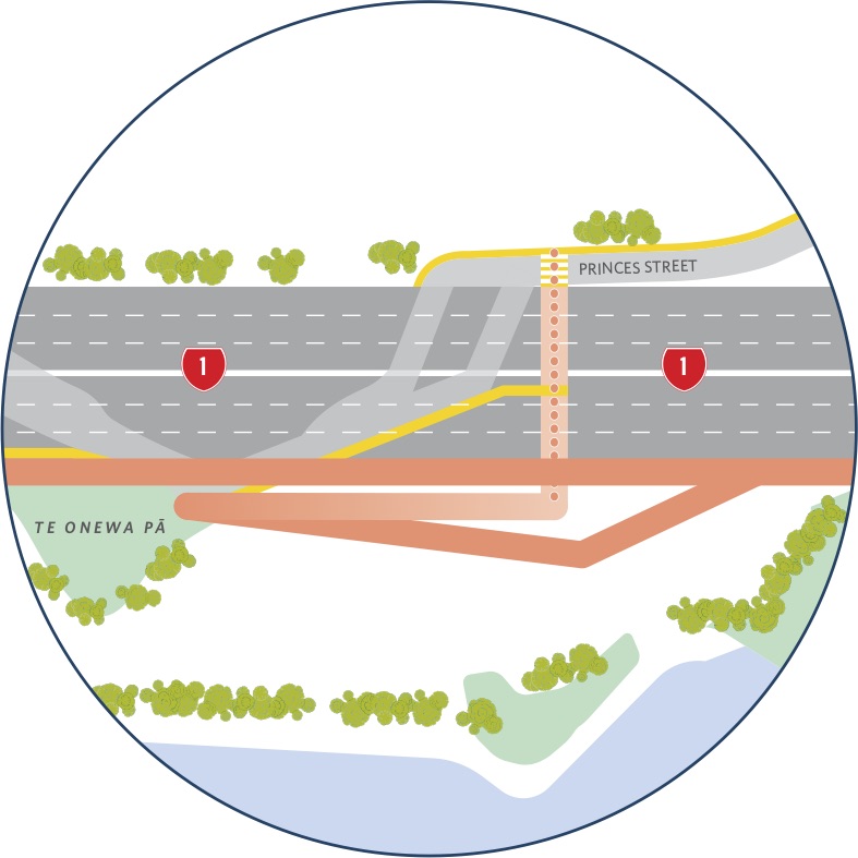
Northcote Point Landing
The latest design for the northern landing includes significant improvements at Stokes Point/Princes Street – notably, a seamless direct route northward and a high-quality local access – but it is important to note that these benefits will be made possible in part by acquiring 6 properties on the eastern side of the bridge.
Property acquisition is not unheard of for major infrastructure projects; Waterview required removing hundreds of houses, the Central Rail Link has likewise required many properties, and a project like Mill Road may affect even more. At a human level, any property acquisition is understandably upsetting for the property owners and occupants involved, and we acknowledge that.
One of the biggest changes enabled by the proposed acquisition is that the main path can continue down the northern viaduct of the bridge towards the old toll gate plaza – creates a seamless connection from the “Skypath” bit to the “Seapath” bit, rather than sending people off the bridge in order to walk, run or bike along Princes St itself.
Crucially, with the main route to the path no longer directing people through a residential area at street level, NZTA is now aiming for 24/7 operation of the path. Given the original plan would have closed the bridge to public access from 10pm – 6am, this will be a huge improvement and very welcome news to everyone who’ll be using the path.
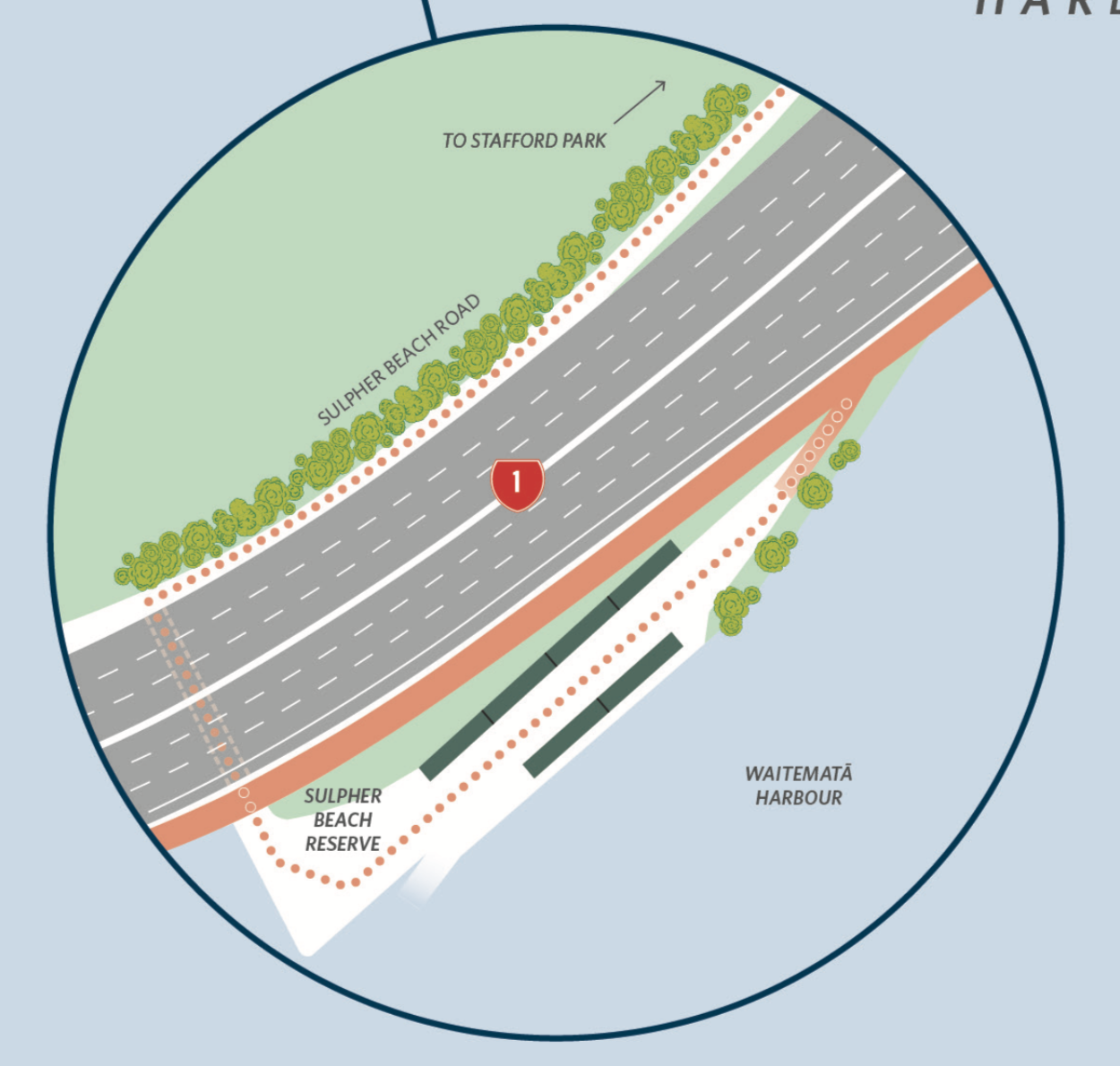
Sulphur Beach Road
Those who have been following the Seapath design for a while may recall that the project was first intended to cross under the motorway at Sulphur Point, using Sulphur Beach Road, which runs between the culturally significant cliffs and the edge of the motorway.
This was not desirable, as Sulphur Beach Road is narrow, wedged between the cliffs and the motorway. And, while it doesn’t have much traffic, it would need to have been treated as a “shared space” in order to retain access via car. In the end, it just wasn’t wide enough to provide a safe and convenient space for large numbers of walkers and bike folk, so NZTA has relocated this section of route.
Sulphur Beach Reserve is still a fantastic place to take a selfie against the city skyline (and more!), and locals will be able to access the path via a spur at the boat lockers.
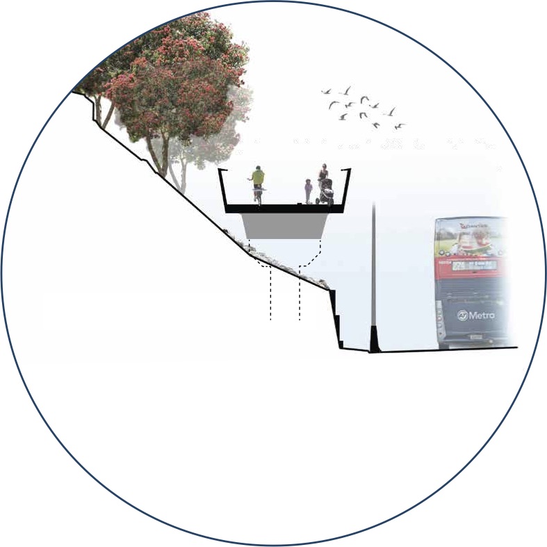
The Toll Plaza Underpass
The dotted line in the above picture shows the underpass path below the motorway, which used to serve the Toll Booths near the police base. Nowadays, it connects Northcote Point to Sulphur Beach.
Over the years, many people have suggested using this path, which is well-used by walkers, as a formal part of the cycle route. The issue is that the underpass is narrow and long with low ceilings (take a video tour here), unsuitable for all kinds of travellers, let alone as part of a highly popular route. However, it’s a useful link for walkers, and will be accessible from the Northern Pathway.

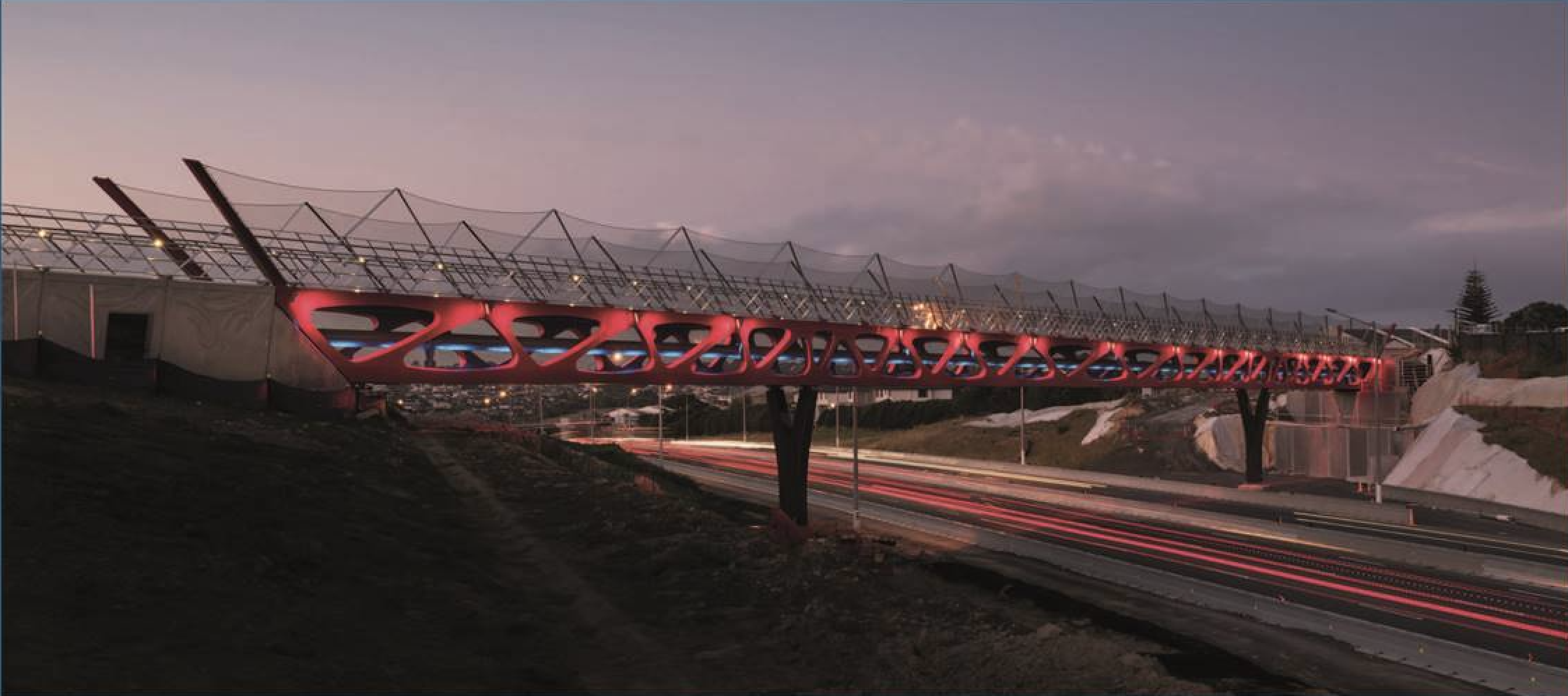
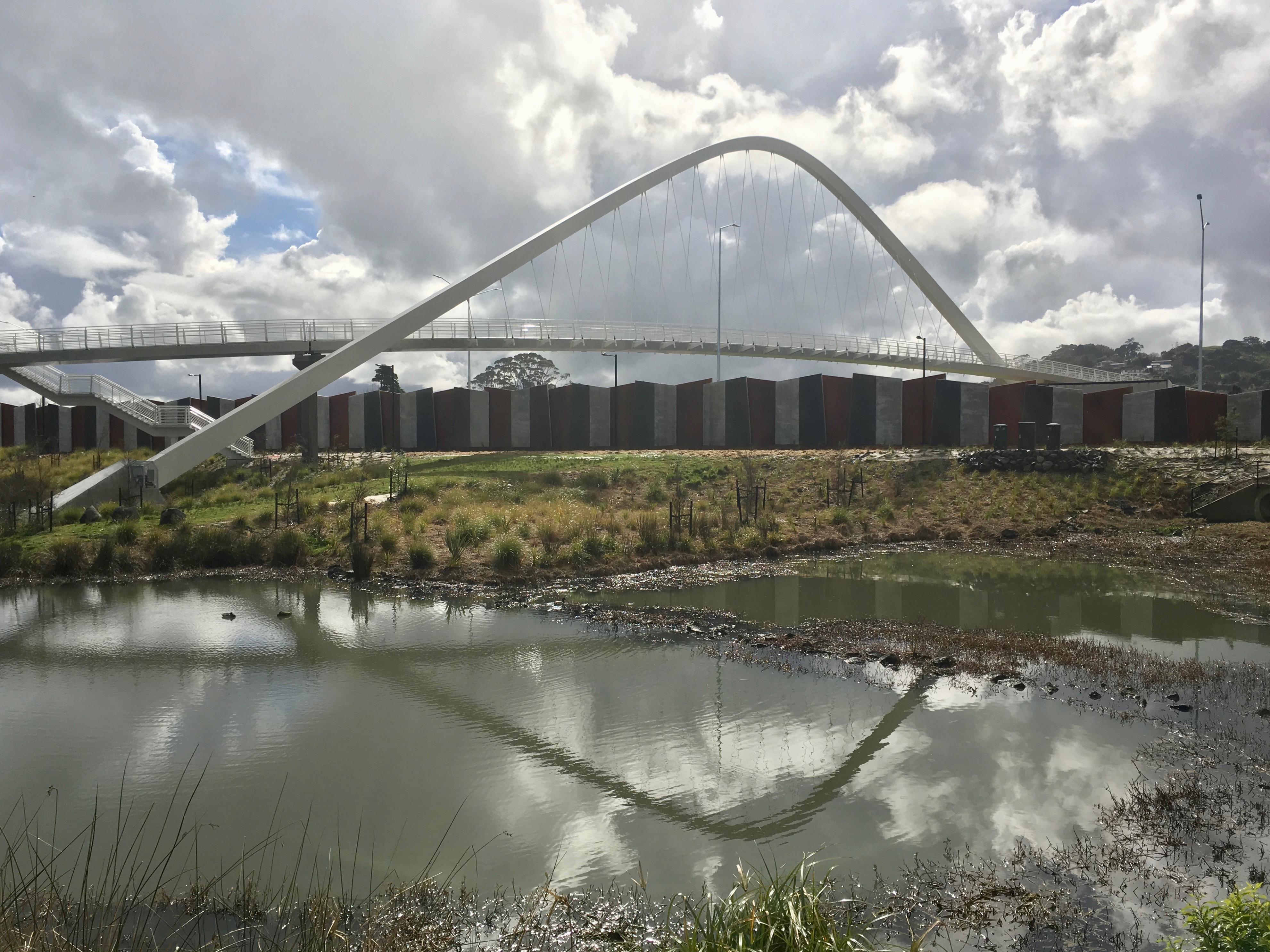
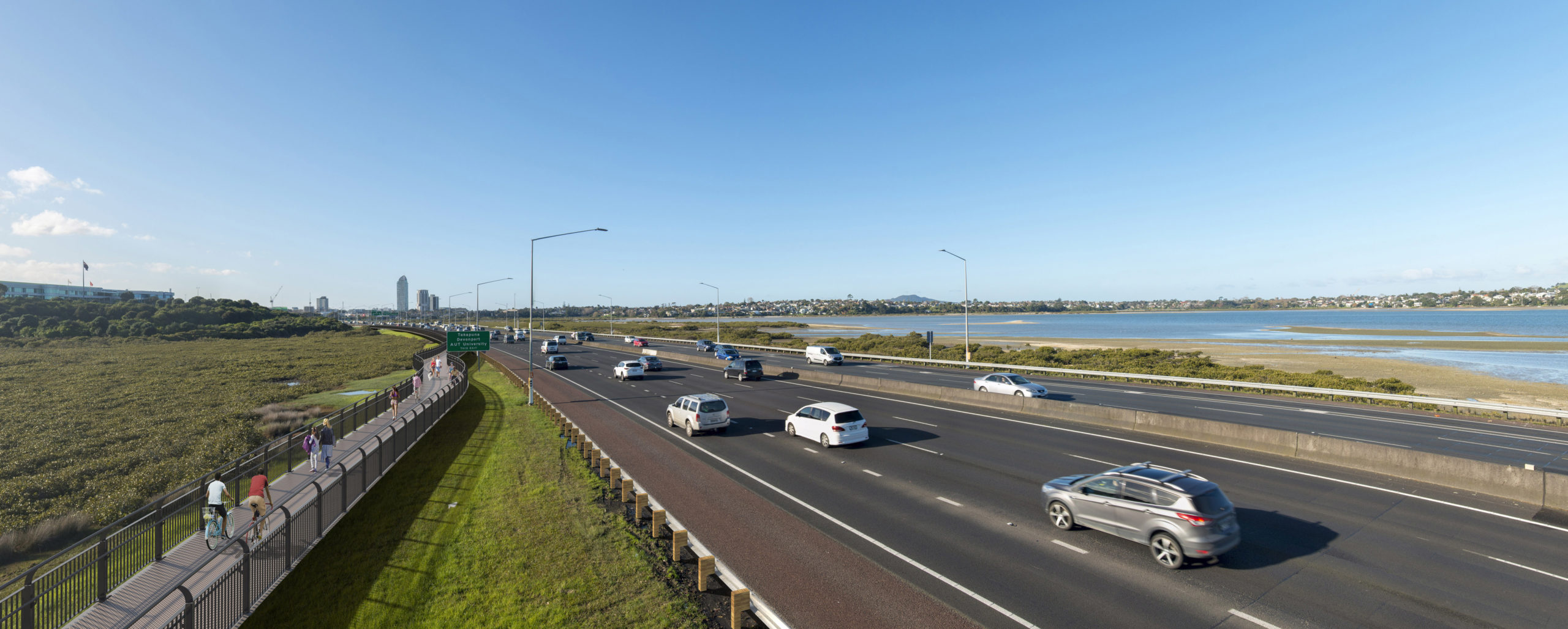
A New Bridge Up and Over the Motorway
Heading north from Sulphur Point, the Northern Pathway finds enough space to continue along the motorway without having to move the seawall – and then rises up to cross over the motorway lanes to the edge of Stafford Park. There’s a fabulous opportunity here to add to the portfolio of spectacular bridges that tie into local landscapes and celebrate mana whenua art and history – see for example, Tirohanga Whānui bridge over SH1 near Albany, and Te Whitinga over SH20.
And of course crossing over north of the Stafford Road off-ramp means people using the path won’t have to interact with local traffic going to Sulphur Point or vehicles accessing the police base; nor will you need to cross the Stafford Road off-ramp (which NZTA were not keen to restrict access to nor add traffic calming to).
Alongside Stafford Park…
The path will stay elevated through this section and into the Onewa Road interchange, which will help avoid issues with rising sea levels and the need to climb over the northbound Onewa Road off-ramp, rather than having to dip down (and take a bath during a king tide).
… to the Onewa Road Interchange
This is another section that is difficult to visualise without more detailed graphics. The details are still being worked out, hence the lack of renders. But we understand from talking with the designers that the up-and-down-and-through effect will not be as dramatic as it looks at first glance.
The parameters we can see are:
- the lengths of the segments of path
- the height of the Onewa Road bridges for on- and off-ramps (6m above the motorway)
- pedestrian underpasses do not need the full height clearance the motorway does – because people walking and biking aren’t as tall as double-decker buses
We’ve been advised that the maximum gradient through this area will be 10% – similar to the steepest part of Grafton Gully, but for only a fraction of the distance. Other sections through Onewa Road will be around 5-7% (comparable to the uphill parts of the Harbour Bridge, which is around 5%). We think with a bit of work in detailed design, it should be possible to reduce maximum gradients at Onewa Road below 10%.
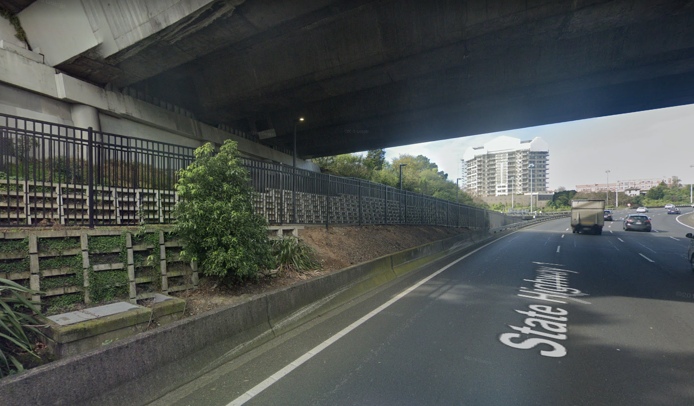
For comparison, here’s how the Grafton Gully pathway fits under the Symonds St overbridge, without needing to be at motorway level.
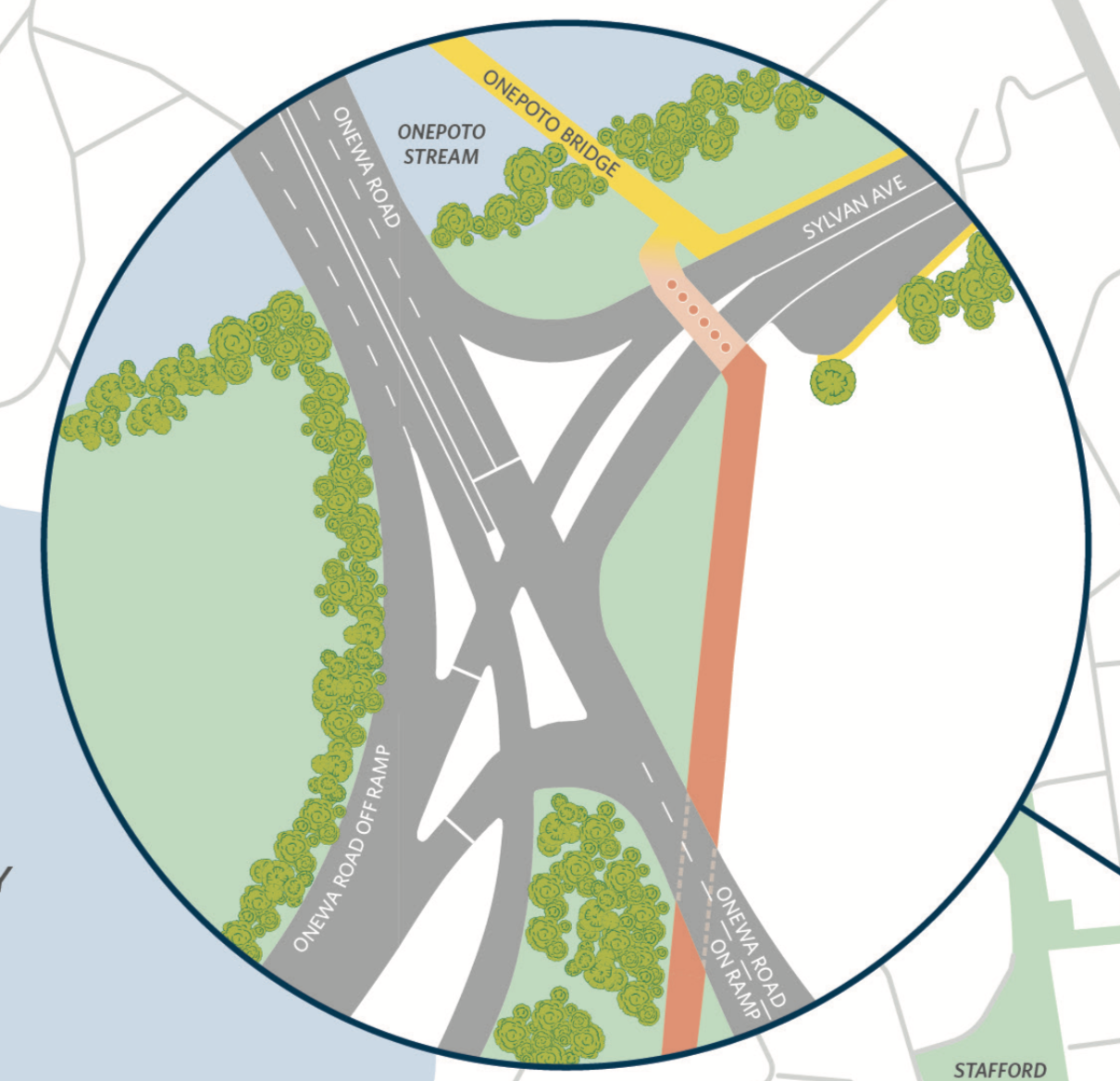
Onewa Road Spur
Previous plans had the path going under the Onewa Road bridge, creating a natural connection to Onepoto Domain, Sylvan Ave and Onewa Road. However, this route faced risks of inundation during king tides and with rising sea levels.
While the path now weaves through the interchange, a spur has been retained for users wanting to leave or join at Onewa Road, incorporating an underpass below the north and southbound on-ramps and a crossing over Sylvan Ave. Note that Onewa Road traffic has priority over Sylvan Ave, which will allow plenty of crossing time for path users.


Exmouth Road
Leading into this access point, the shared path narrows to 2.5 metres for a length of 60 metres. This is a feature that has carried over from the previous Seapath designs, and is due to two key constraints in this area:
- The path is bounded by a bus shoulder for the Northern Busway on one side and culturally significant cliffs…
- …and a healthy pohutukawa tree that is more than 100 years old on the other.
We’re comfortable with this narrow section, because:
- 60 metres is not very far
- the path in this section is relatively level
- and the approaches from both the north and the south have clear sightlines
- although we’d expect some signage to reinforce safe sharing of the path here
Note: Exmouth Road itself is not shown with a connecting path, as it’s outside the motorway corridor and thus outside the scope of this NZTA project. Ideally, NZTA, Auckland Transport or the Kaipātiki Local Board will see fit to plan and fund a local link here.
Tuff Crater
There is an existing walk/bike path around Tuff Crater, but not where the Northern Motorway shares a boundary with the crater area. The Northern Pathway will bridge this gap by providing a connection across the inlet for those wanting to walk or cycle around the crater.
Esmonde Road – the end of Phase 1
Current plans show the Northern Pathway ending with a light-controlled crossing across Esmonde Road. For many reasons, and as pointed out by many of you, crossing large motorway interchanges “at grade” is not always ideal. (The Lincoln Road crossing on the NW Cycleway is an obvious example – you’ll recall we called for an underpass or bridge there from the very beginning, and we will continue to press NZTA and AT to deliver on a safer crossing here. The next likely opportunity will come with the NW busway).
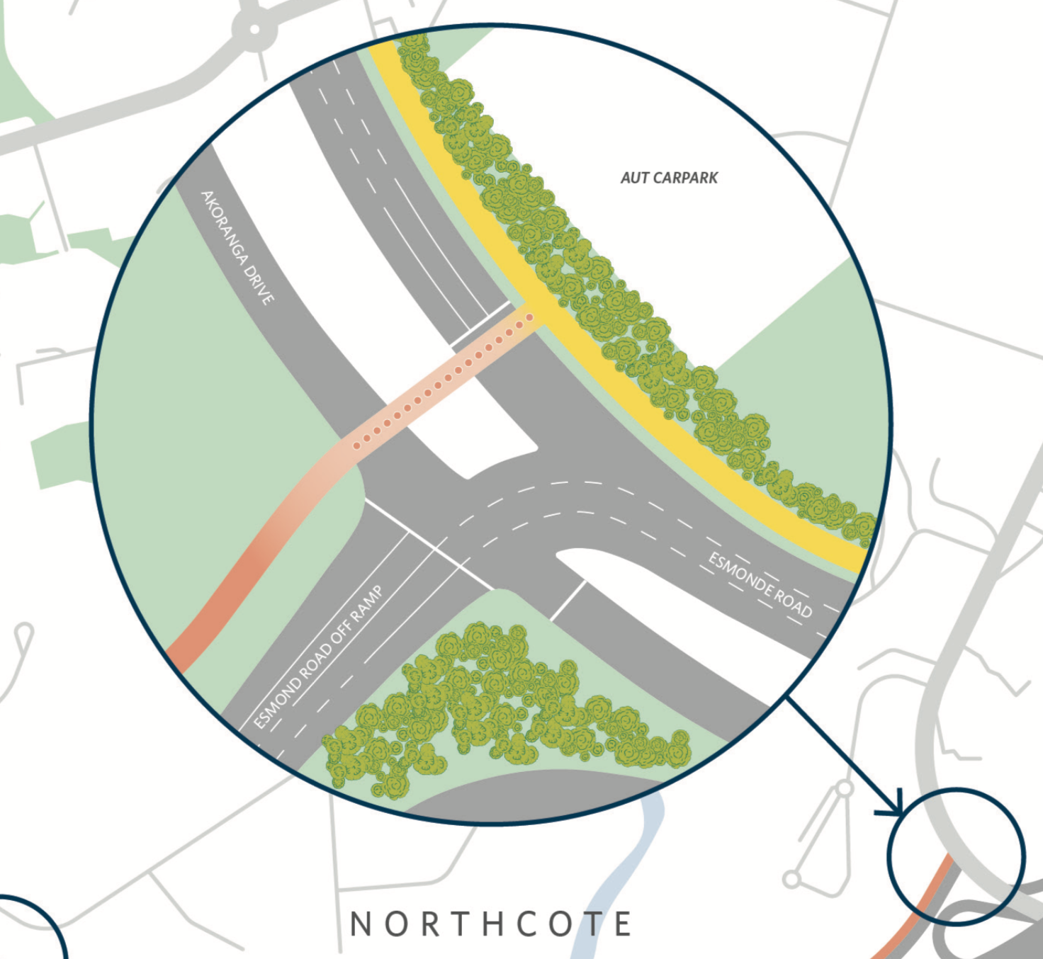
Phase 2 of the Northern Pathway project (Akoranga to Constellation) is currently developing its business case. It’s not known yet which side of the motorway the path will run along, north of Esmonde Road. As a result, the connection between the two sections is being left for the Phase 2 project.This means that as Phase 2 moves forward, the thinking around this connection may change – or indeed, another connection may be made to the path.
People will want to get from the Northern Pathway to businesses on The Warehouse Way, to AUT, and to the Akoranga Drive shared path. So it is likely some form of safe access will always be required at this intersection, even if the alignment of the main path is slightly different.
Be assured that, as part of our involvement in the early planning for Phase 2, we are advocating vigorously for the connections here to be safe, clear and convenient, befitting NZTA’s mandate to encourage more and safer walking and biking.
Right, that’s the details! Ready to give your feedback?
Use the big pink button below. Here are the key points again:
- What do you like about the Northern Pathway design, and why?
- The continuous 4.6km of pathway linking the city to the Shore
- The increased width, to 5m over the harbour bridge and 4m along the Northern Motorway
- Underpasses/overpasses for ease and safety, to avoid intersections and crossings
- Access on and off the path at multiple points
- Being able to use it 24 hours a day and 7 days a week!
- How do you think we could improve about this design, and why?
- Ensure a seamless connection to Phase 2 of the Pathway (Akoranga to Constellation)
- Provide separation between pedestrians and cyclists wherever possible
- Add a connection to Exmouth Road in Northcote
- Upgrade the connections across the motorway at Esmonde Road for people accessing the path from Devonport and Takapuna
- Love to see some artistic design work for bridges and major structures


