
Several months ago we shared a wayfinding tale of woe by Neil, who tried to bike from the city home to Henderson by dead reckoning – and got dead confused. At the time, we nudged AT to address the situation for new riders, given the volume of people who are keen to try the city’s cycleways, if only they can find them.
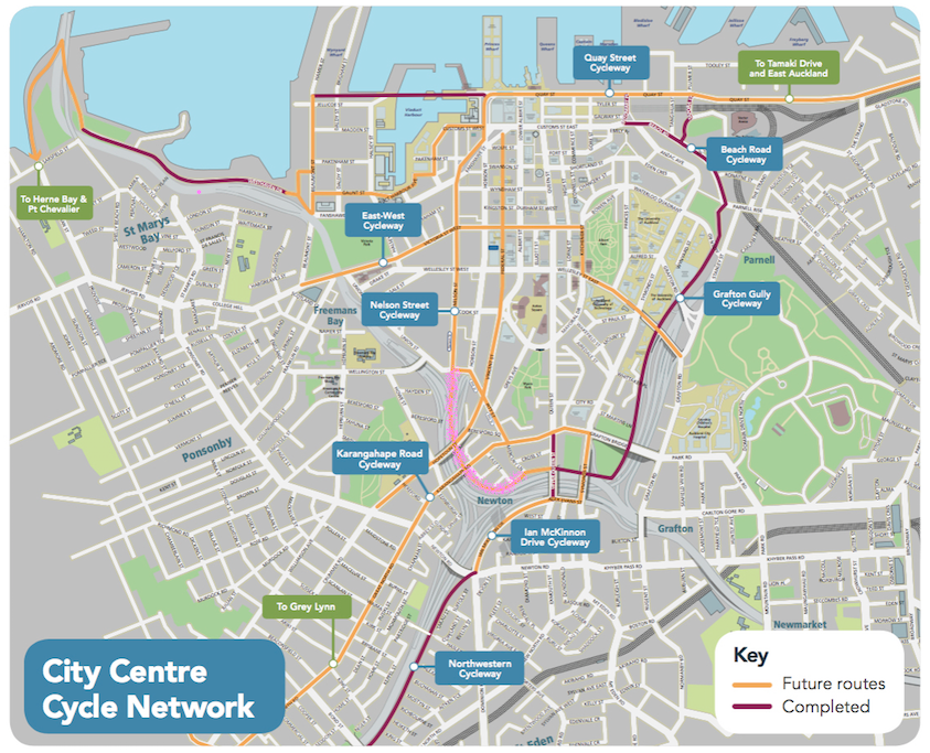 The city centre cycle network map is great, and there’s now one for Waterview, too. But in our experience, people also need simple, intuitive, and unignorable on-the-ground signage. This will be especially true over the next few years, with increasingly popular and connected bike paths, and more and more of us eager to enjoy them.
We’re a pioneering sort of people, but we still need stars and signposts to navigate by.
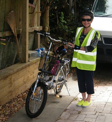
Take Wendy, for example. She came to town from Birkenhead with a simple, straightforward mission, and – well, read on for her tale of derring-do and dogged determination…
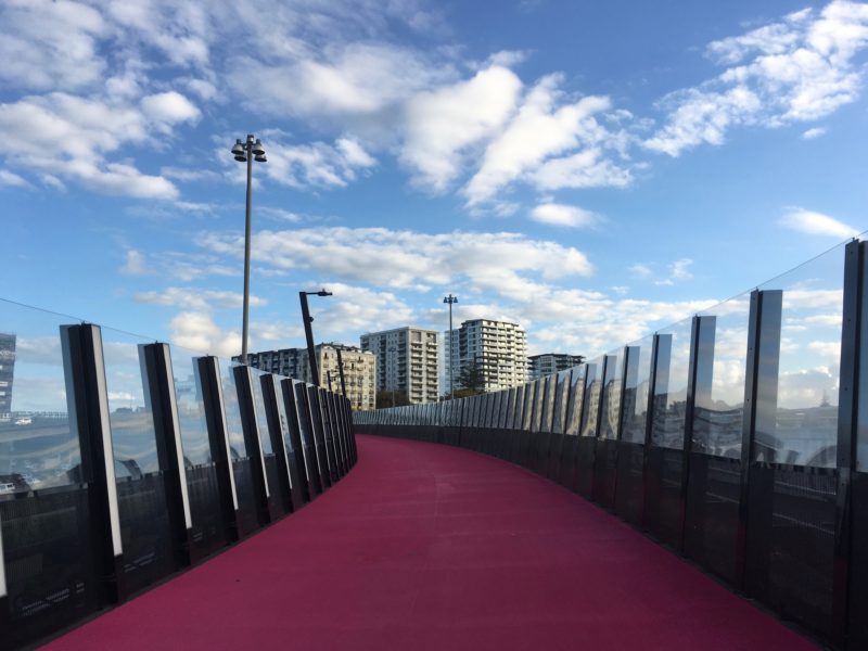
I’ve finally fulfilled my wish to pedal Auckland’s pretty pink cycleway. Bear with me, have a giggle (and buy a GPS).
I caught the late morning ferry to town, radiant in green fluoro, with croissants, water, Gold Card and phone in the basket of my feisty e-bike Ebo. According to Mr Google I would ride up Albert Street then traverse across town to join the Nelson Street cycleway which would deposit me at the start of the pink pathway.
Albert Street was a morass of mud, scaffolding and sweating, swearing workmen slogging away on the light rail project. The sole access was a skinny footpath; a significant setback. My feet hurt, which is why I ride a battery bike. Pushing Ebo, I trudged up the narrow alley trying not to gore oncoming pedestrians with Ebo’s handsome handlebars.
By the time I reached Victoria Street I too was sweating and swearing. I scooted across several ‘cyclists cross now’ lanes and hopped onto Ebo at Nelson Street, keen to join the promised pink path at the end. I scooted cautiously over more crossings, and suddenly found myself descending Union Street. Even with rose-tinted sunglasses, the pavement was patchy and nothing like pink.
A very tall young woman leading a very short-legged doglet appeared so I asked for directions. She was courteous but clearly thought I was loony as well as lost.
‘Wrong road!’ she declared. ‘Follow me!’
So six short legs – two fluoro and four furry – fell into step behind the loping leggy lady. We reached the top of the hill.
‘Over there!’ she cried. ‘See the big pohutukawa? Behind that tree, cross over and you’ll find the pink cycleway.’
I went behind the tree, to the mouth of the motorway exit. There were two ‘cyclists cross now’ lights, one straight ahead and one to the right, neither indicating a pink path. I teetered on the kerb between the tree and the road in peril from cars hurtling around the corner. A young man on a bike appeared.
‘Follow me!’ he said, and pedalled straight ahead, pointing to the right as he disappeared.
I scooted right and lo, there was the promised pink path, and I glided onto it.
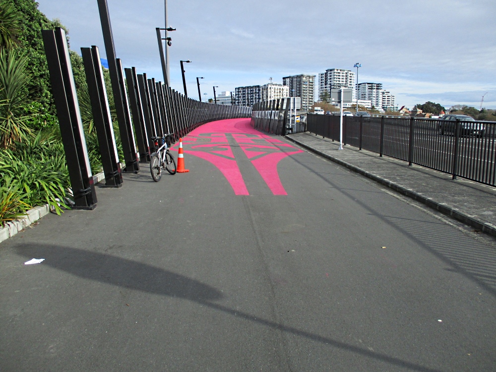
Ebo is very swift and quite soon I came to the end. I wanted to link up with the Grafton cycleway which would take me back down to Quay Street, but the broad pink path quickly dwindled to a bumpy footpath with a faded painted bike on it. This seemed odd, but I followed my nose and the painted bikes and whizzed along until the path widened – and a sign appeared announcing I was on the Northwestern Cycleway. Bugger.
I stopped, did a turnabout and followed a footpath the other way which took me to the top of a hill presumably still in Auckland but which might also have been in la-la-la land. A girl on a bike puffed up, but didn’t know which way to Grafton Gully either. She sped off down another busy road, while I sweated and swore some more.
I thought: ‘Where is a policeman when I need one?’ My mother always said if I was lost, to ask a nice policeman for help.
Vavoom! Blue and red flashing lights appeared, and a police car screeched to a halt just downwind. I was not the quarry – they’d cornered a culprit in a dodgy car – but I chose to believe that my anguished mother Upstairs had sent them to my rescue. I whirred down beside the patrol car and the senior policeman gazed in amazement as I materialized beside him; I think he thought the sweating spectre in glowing green was an alien that had popped out of the hedge. He left his mate to deal with the driver and listened to my tale of woe.
‘I haven’t cycled the pathway myself yet,’ he mused. ‘I don’t know where you join up with Grafton, but I can direct you to Queen Street.’ This meant another uphill trudge so I hobbled along and eventually came to Karangahape Road which was a race-track definitely unsafe to cycle. So I scooted smartly along the footpath to Pitt Street, joined the throng and thence back to the start of Nelson Street cycleway.
At Fanshawe Street, I rode across to the Viaduct, found a bench in the shade and was joined for lunch by a lovely Pakistani man, a German girl and a courtly old codger from Coatesville who was keen to hear about Ebo’s escapades in la la land.
I caught the mid-afternoon ferry back to Birkenhead, and headed down Maritime Terrace to the Northcote Bowling Club where I did a few doughnuts in the gravel carpark to distract Geoff from his tedious game. He didn’t even notice.
Never mind the Yellow Brick Road, just don’t Wend-y your way onto the pink cycleway without a GPS.
—
We’re grateful for Wendy’s hilarious honesty. Of course, once you know how the pink path connects to everything else, it’s obvious – although it may take a few goes to get it right. And the promised redesign of the intersection on Upper Queen St will surely help. But clearly, the link from Lightpath to Grafton Gully is still not intuitive, and ditto the connection at the top of Nelson St to Lightpath itself, and the path to and from the Northwestern.
So here’s our question for readers: what kind of simple on-the-ground wayfinding would help make the central city connections crystal clear, especially to first-timers?


