
Updated: we’ve launched a petition to gather public support for bikeways on Dominion Road along with light rail. It’s the smartest way to protect the hundreds of people who already bike along this iconic street, and the best way to future-proof our city and leverage this once-in-a-generation investment, by allowing thousands more people to bike safely to and along our flattest, most direct, and most delicious boulevard.
If you share our vision for safe cycling on Dominion Road, please add your name to the petition – then share the link and pass on the good news!
Light Rail (LRT) across the isthmus and to the airport is a hot topic, and Bike Auckland supported it in principle in our recent submission on the Regional Long Term Plan… with one clear caveat:
Bikeways must be included in LRT projects, both to and along the future routes.
Why?
- Public transport travels on fixed routes, but everyone’s start and end points are different – so how people cover the ‘last mile’ is key. Walking is great, but bikes extend your range from a few hundred meters to a few kilometres. That makes bikes a perfect strategic combo with LRT. So we need bike paths to future LRT stations, and great bike parking in the vicinity.
- LRT projects involve really major streetscape upgrades – so are a one-off opportunity to improve the often horrendous bike safety on these roads, and to ensure local access. Running along main roads and through town centres, LRT tends to go exactly where people also want to ride to for shopping, for entertainment, or to local schools, workplaces, and other destinations. So we need proper bike conditions along LRT routes.
We’ll discuss biking to stations in a future blog post. For now, we want to talk about that second point – biking along LRT routes – and in particular, the Central Isthmus/ Dominion Road section of the city-to-airport route.
Why are we zooming in on biking along? Not because biking to is less important, but because along is so much harder to get right after the thing is built.
You can always add feeder bike paths to the LRT later – sprouting branches off the main trunk, if you will. We’d love those connections to be part of the initial schemes of course, but nothing is cast in stone or prevented if a new LRT project doesn’t have them. And once the tracks are in place and the trains are running, the argument for these bike paths will only get stronger.
Not so for bike facilities along a LRT route. Light rail projects are costly, and involve years of construction disruption for traffic, residents and businesses – particularly when they’re being threaded through historic town centres like those on Dominion Road. After the project is finished, good luck getting any further significant change to the street layout for a couple of decades.
Meanwhile, this route is currently used by many people on bikes for good reason: it’s a direct north-south route through the heart of the isthmus and one of the city’s longest strings of shops. It’s a place to be, and the route to ride.
Unfortunately, the current plans for LRT routes do not seem to take bikes into account!
Our repeated requests for discussion with AT’s LRT team have resulted in… crickets. (The team, sadly, has a reputation for being a silo even within AT, to the point where it’s clear that AT senior leadership has instructed them to keep their cards very close to their chest).
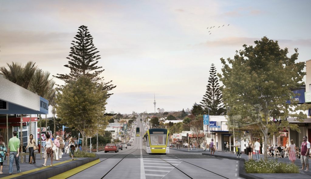
Certainly, the small nuggets of concept imagery that have been released seem to not show much on bikes – at least, not in the artists’ impressions of the Central Isthmus parts of the route, like this one:
So we have ONE chance to get biking along LRT routes right. Below, we explore how that might work.
What do we want?
Good bikeways can take many forms, but the key requirements are:
- Being and feeling safe. That means you need either physical protection from vehicle traffic – or you need to bring down both traffic speeds and volumes. And for pedestrian safety and comfort, you also really don’t want to force bikes into the footpath space.
- Direct and flowing. That means not putting people on back routes that zig-zag through the suburbs. What people really want is to visit shops on the main street, or get to the next suburb without having to add several kilometres in twists and turns. It also means not mixing bikes and pedestrians, as that will simply hobble convenience and safety for both.
A route through an urban area like the Dominion Road section of the future LRT doesn’t offer the ability to tidily place people on bikes on a parallel path, the way our motorway bike routes do. So bikes need to be integrated on Dominion Road itself, not sent somewhere else.
And the ‘alternative’ back street routes for bikes are a bad compromise – as we argued last time Dominion Road underwent a streetscape revamp as part of an earlier proposal to upgrade the street for buses. Somewhat ironically, these back street bike routes were the only part of the project that was actually completed. But those streets still have too much traffic, vehicle speeds are too high, and the routes are far too circuitous and illegible to see much use. While we understand the numbers of people biking on these routes have increased somewhat, they’re still far from best practice, all-ages-all-abilities routes – and they don’t go where people want to go (neither through nor to).
So again, decent biking provision as part of the LRT scheme needs to be ON Dominion Road. And at least wherever possible, it should be in the form of protected bike lanes.
Why do we want it?
Most of all, we want it because people on bikes want to go to exactly the same places people on cars, foot and LRT want to go: to the main street! And that, in this case, means to the town centres of Dominion Road.
Yes, some will also simply be passing through, on their way to the City Centre or elsewhere – including many of the current riders.
A city that takes cycling seriously tries hard not to make places like town centres inaccessible by bikes. And, when it comes to otherwise laudable goals like ‘we need this space for better public transport’, a city that understands how bikes amplify public transport will find a way to provide for both, simultaneously.
On top of all those town centres and amenities, there’s a whole row of schools arrayed along the route, as you can see here:

That’s thousands of students who could potentially bike to school, taking potentially thousands of cars off the roads every morning and afternoon. Sure, some of those trips can use back streets. But if you essentially exile kids on bikes from Dominion Road by not providing safe bikeways, many schools will just be too hard to get to on a bike, e.g. if you have to go all the way round a long block to avoid the main road.
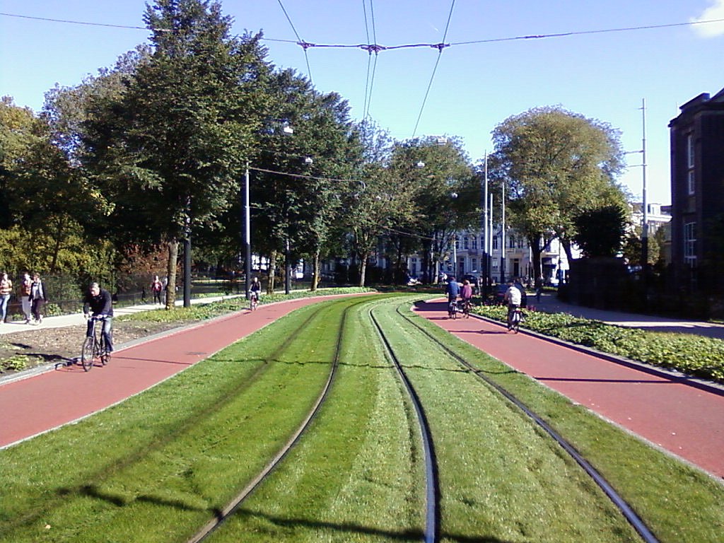
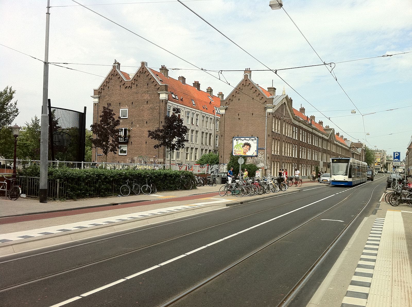
As we can see from Europe, LRT and all-ages biking can be combined on main streets not just efficiently, but beautifully.
How can we do it on Dominion Road?
1. In the middle of the blocks
Obviously, if there were no trade-offs to be made, then in 2018 a city would automatically add protected bike lanes to any major urban streetscape renewal. But as always, there are constraints and competing demands that make things trickier. Among them:
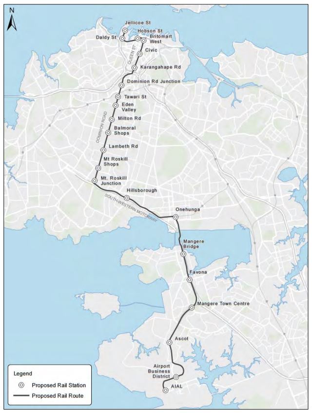
- The typical cross-section along Dominion Road is 22.6m (based on the surveys during the 2010s bus route project). At some town centres, this reduces to a typical 20m (though at Mt Roskill it actually widens to 24m). This carriageway width is the main limitation we have to work around: there’s only a very finite amount of space.
- Parking is often something people fight to preserve – but really, if your goal is to keep on-street parking on Dominion Road, you can’t change anything. Even the 2010s bus route project proposed removing all of the parking, which it balanced by adding more in side streets. An LRT project will be even more attractive for retailers who understand cities with thriving LRT / tram systems, so if anything, LRT means less need for on-street parking on Dominion Road than in the busway project.
- In the town centres especially, footpath widths need to be more than just ‘acceptable minima’. Right where the road gets narrower, the need for pedestrian space increases too.
- The LRT seems all but certain to run along the middle of the road on its own right of way, likely a slightly raised median or grass strip. This is so it doesn’t get caught up in the same congestion it’s intended to avoid in the first place; and so people can left-turn into their driveways without needing to cross the tracks. But this also means that at every station, the LRT will need platforms in the middle of the road so people can enter / exit the tramcars – you can’t board from the footpath.
- And of course the expectation is that, at the very minimum, there will be at least one live traffic lane each way (although Greater Auckland have led the call to remove cars fully from the most constrained town centre sections – more on that later.)
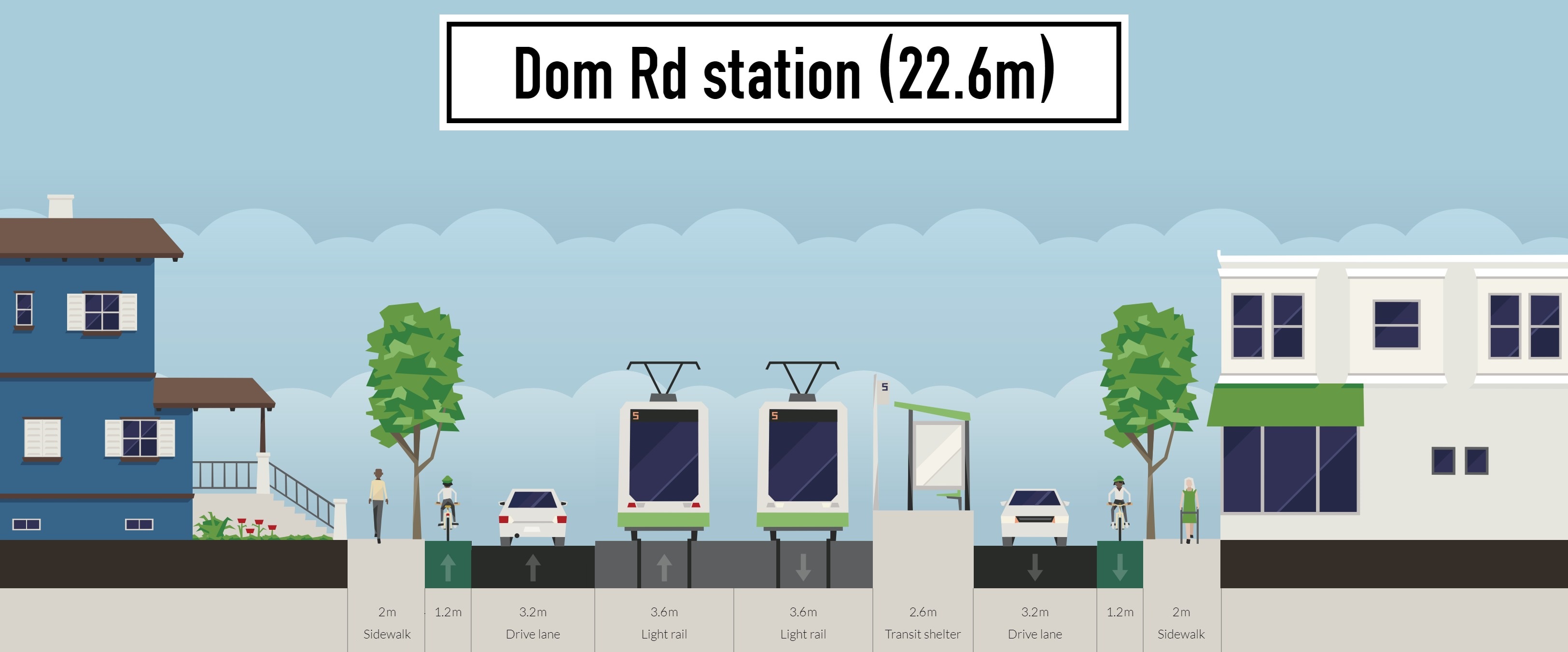
Considering all these constraints, can we make a bike-friendly design work? Let’s have a look, starting with that 22.6m wide mid-block section:

Now, we don’t know exactly how much width any chosen LRT design will requires, but 3.6m each way appears to match typical requirements (some could be even narrower, but let’s be pragmatic).
The good news is that it does work. Our typical Dominion Road mid-block can fit everything – good footpaths, separated bike lanes, car traffic lanes and of course the LRT. The bike lanes wouldn’t have any significant buffer space, but are reasonably wide and would be raised up on a kerb level to protect against encroaching drivers.
The trees would need to have tree pits that extend under the footpath and the bike lane, so there’s enough growing space to become substantial trees in the long run. But that’s the benefit of a whole-street revamp, you can do these smart things.
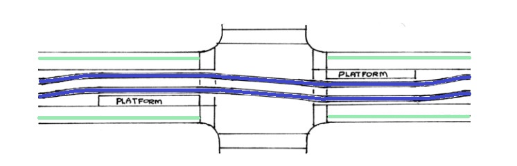
But how would it work at a station? Well, the key smart thing you can do there is to off-set the stop directions. For example, the citybound stop might be 50 or 100m further north than the outbound one. Maybe the two stops are on opposite sides of a signalised intersection. This helps because you only need to find space for one station platform at a time:
Will this give us enough space to fit everything in?
Now, as you can see, things work – but are a little tighter. As much as we’d prefer consistent widths, we suspect that bike lanes through the station sections would need some narrowing. While 1.2m is definitely narrower than desirable, the bike lane would still be slightly raised above traffic and thus feel safe. If one rider wanted to overtake another, they’d definitely need to dip onto the road – or just wait until they’d passed the station, of course. And with a single traffic lane through here, it will be easy to slow down adjacent car traffic.
Whether trees can fit into the station section is an open question. By contrast with the mid-block section, they’d be in the footpath space. This is possible if we use walkable tree grates over wider tree pits. Here’s an example from Melbourne:

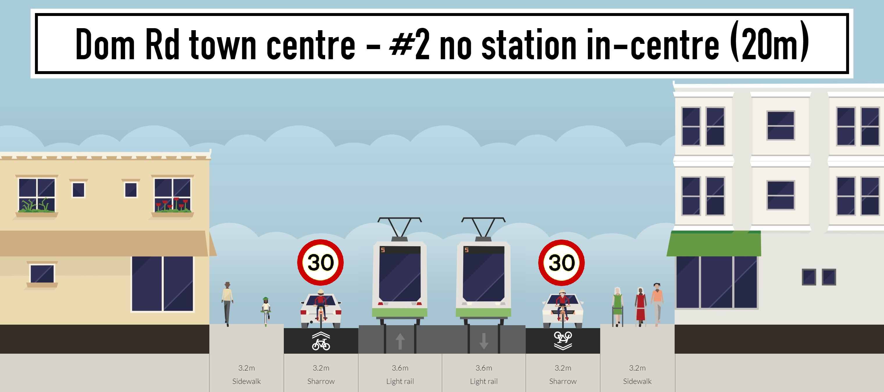
2. Through the shopping villages
This is where it gets really challenging. Let’s see a few different options:
Option #1. As you can see, even with one LRT stop (staggered, as discussed above) and even without bike lanes, trying to fit LRT through the town centre will be difficult. Unless the designers are able to really narrow the LRT corridor below the 3.6m shown, there won’t even be enough space for proper town centre footpaths. It would feel mangy and mean – not the kind of upgrade a village needs!
Plus, people on bikes would have to ride on-road through here. While it would be easy to keep traffic speeds down to 30 kph (or maybe even 20 kph), it wouldn’t be nice. Reasonably safe, given single lanes and no turning traffic – but not nice or all-ages friendly.
But all said and done, in our opinion the narrow footpaths make this option very unlikely to even be considered anyway. Auckland has developed a wee bit more urbanism savviness than that. So onwards to…
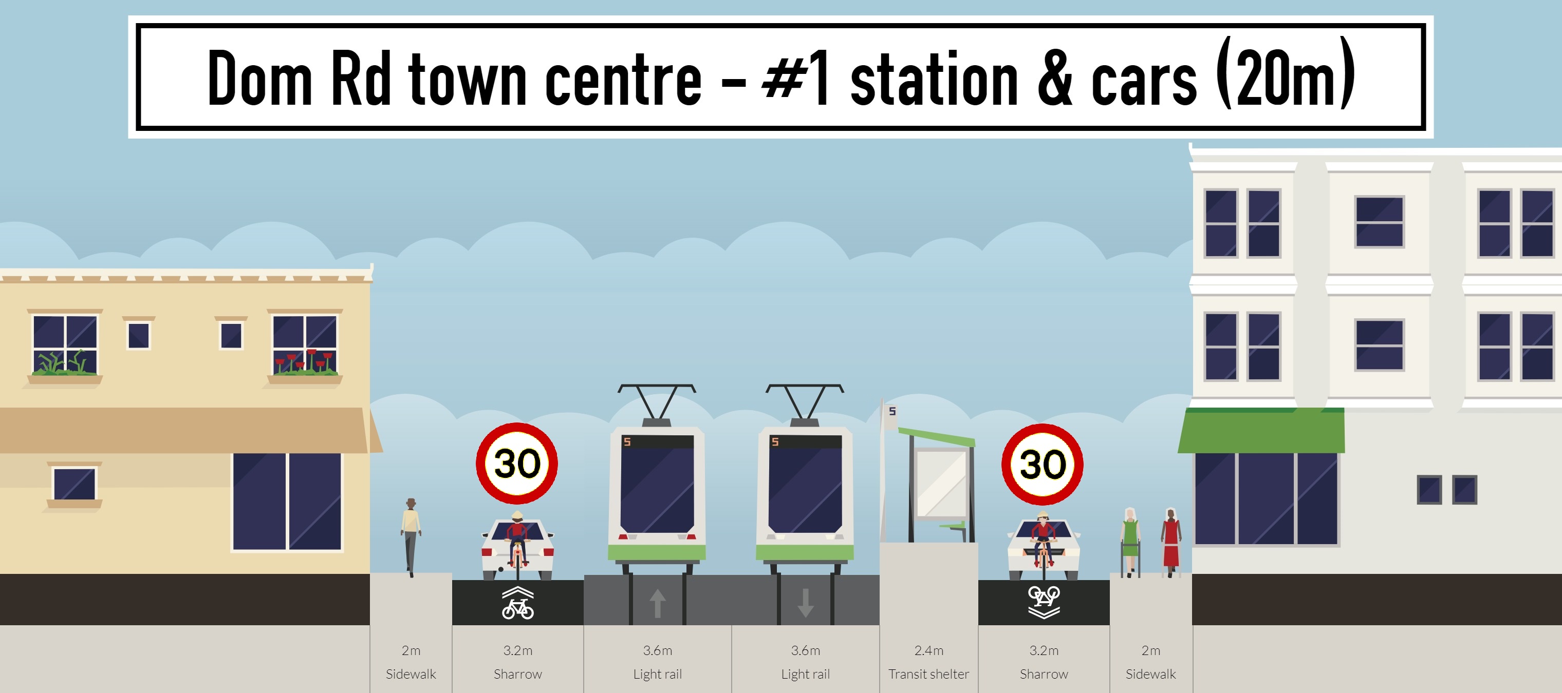
Option #2 would be to keep the stations out of the narrower village centres. Though this isn’t ideal from a public transport perspective, you could position the LRT stops at the edge of the centres – and, where the run of shops is longer, you could have a stop at each end (Balmoral North and Balmoral South, say) to reduce walking distances to the shops.
Where are the bike lanes in this one? Still missing – because, realistically, where there’s a shopping and people hub, footpaths need to be wider than 2m, as per Option #1. And once those footpaths are set at a more sensible width, even removing the station leaves no space for traffic lanes AND bike lanes.
Ironically, we suspect this could be an option our planners would consider for the narrow sections… but it’s still not really all that awesome.
Which leads us to…

Option #3. Cars are allowed to travel in one direction (which side/direction would be determined by factors such as available alternative routes, and whether there are any destinations that would be difficult to provide rear lane service access to).
By removing one car lane, we are able to widen the footpaths to something vastly more appropriate to a town centre. Then we can provide a unidirectional bike lane in the other direction (which can be a bit narrower, not being next to cars) to allow active modes to still travel in both directions.
Sure, people biking in one direction would still need to ride on the road – but as we discussed above, it will be pretty easy to traffic-calm a section like this. Overall, a good solution, though still a compromise.

Option #4 Now we’re talking! Not only would the removal of the general traffic lanes allow us to design really wide footpaths, add bike lanes AND a LRT stop right in the centre of the shopping strip – we would also have space for trees and landscaping. And it would actually feel like the centre of a community, with wide spaces in front of the shops, greenery and lots of space for people to move and rest.
Would this be too radical? Some may feel so, especially on our very first LRT route, out of a concern that without a through-route for drivers, shops could not survive. The data shows otherwise. For example, only 2% of Karangahape Road’s customers park on the street itself: as on Dominion Road, those who drive to shop tend to park in side streets and parking lots.
And remember, LRT will deliver enormous numbers of people travelling through the town centres day in, day out. With regular services, LRT passengers are much more able to hop out and shop (or come back another day to test that new restaurant they just spotted while going past). Much more so than drivers stuck in a car on a road that has no direct parking spaces anyway.
For all these reasons – and, of course, because it would give people on bikes safe and direct access – we feel that this is what a real, best-practice LRT-enabled town centre on Dominion Road should look like.
What about Hillsborough, Mangere and the Airport sections?
This post has focused almost entirely on the Central Isthmus. So, what about the part of the route between Dominion Road and the airport, including Hillsborough and Mangere – especially with the pressing need to give South Auckland some bike love?
The main reason we haven’t focused on those parts? As far as we know at this stage, and for better or worse, these parts of the route are much more likely to run along the motorways rather than on streets (main, or otherwise). So for those sections, it’s much more likely that any new bikeways will be a separated facility running in parallel, like those we already have in many parts of Auckland. And of course, along some sections of the airport route, these motorway-parallel bikeways already exist – both in ‘heritage’ form, like on SH20 (albeit many parts need improvement, especially at intersections) and in brand new form on SH20A, opened on Friday 22 June.

So for now, it all comes back around to Dominion Road. Solve the really tricky bit, and the other parts will, if not fall into place, at least get a lot easier.
How do we make sure Auckland gets the best out of LRT in town centres?
Big transport projects like LRT can tend to swamp other pressing transport issues. But they can also – as with the massive Waterview Connection – provide an opportunity for brilliant strategic thinking, and creating connections for human-scale travel.
People on bikes need safety and connection, even if (or especially because) we’re still a minority out there. The central isthmus already has higher regular bike numbers than the citywide average of 2%. And we know there’s enormous demand for local bike trips that is being artificially suppressed by the lack of safe bikeways.
This is a huge, huge opportunity. Whatever is delivered for Dominion Road with LRT will be in place for 20, 30, maybe 50 years. We can’t afford to ignore what Auckland will look like in that time, and how children born today will want to travel as they become the adults of the future. We also can’t ignore the local and worldwide rush towards bikes as a savvy and strategic key element of city travel – nor can we ignore the growing local demand to provide for bike travel, safely and conveniently. This is Auckland’s chance to design a truly green corridor. The world will be watching.
https://twitter.com/BrooklynSpoke/status/1005151951053606912
We understand that the LRT project has now moved away from Auckland Transport proper (where, as we noted, it was extremely silo-ed, even within the organisation), and has now been taken over by other agencies of government to drive it forward, though obviously AT will remain in the mix.
Bike Auckland will stay on the case – to speak for you, and for a future Auckland in which bikes are a key part of the picture. In the meantime, start talking bikes whenever you talk Light Rail. Because not only can the two go together – in clever cities, they’re a perfect marriage.
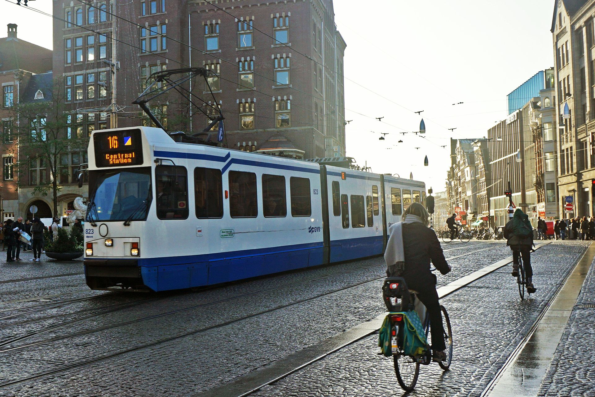
How was your commute to work this morning?#GreetingsFromAmsterdam
20.04 08:45https://t.co/4AQ16xuBQq #Amsterdam #cycling #bikeAMS #livablecities #placemaking pic.twitter.com/20ilZHujCi
— Thomas Schlijper (@schlijper) April 20, 2018
Same street, view from the bicycle seat:
Climate-proofing in Amsterdam: Replace roads with grass & paths for peds, bikes & trams. #qualityoflife pic.twitter.com/5jGqPl5LaJ
— Mitchell Reardon (@MitchellReardon) December 2, 2015


.jpg)