
We’ve got Lightpath and QuayPath, and we’re in the middle of sorting out a whole set of connected Inner West bikeways. And soon we’ll open the first stage of our newest bike superhighway from Glen Innes to the city.
Now, the most exciting, most transformative route is about to launch into the wider public’s view. K Road’s protected cycle lanes will not only form the very heart of our growing bike network, but are also our next step towards bringing real European-style cycleways to Auckland.
It’s been a while coming. Spearheaded by a fantastic Generation Zero initiative that laid the groundwork for a supportive local community, just in time for it to become part of the Urban Cycleway Programme, the project has gone through a LOT of work over the last 2-3 years (some of which we’ve hinted at here and here).
There are huge improvements for cycling – as befitting Auckland’s 6th busiest cycling street (even without proper bike facilities!). But along the way, the ‘K Road Streetscape Enhancement Project’ has morphed into something much more holistic than just a bike project.
It also includes better and wider footpaths, which will make shopping and events on K Road more fun, and will cater for all the future users of the new City Rail Link train station and eventually the proposed Queen Street Light Rail Line station. There are also improvements for buses, both on current routes and for the extra services that might travel through here when the Western Busway eventually happens.
Of course, the heritage and character of K Road are both a challenge and an opportunity. You don’t change a street like that without having to at least nudge a few sacred cows… but we think Auckland Council and Auckland Transport have done a great job so far in bringing the community along, with lots of direct contact and opportunities for involvement.
We expect a few concerns to remain – but we’re also confident that there will be heaps of support for this ‘final’ design. Because it’s really pretty neat.
Let’s step through the areas from West to East:
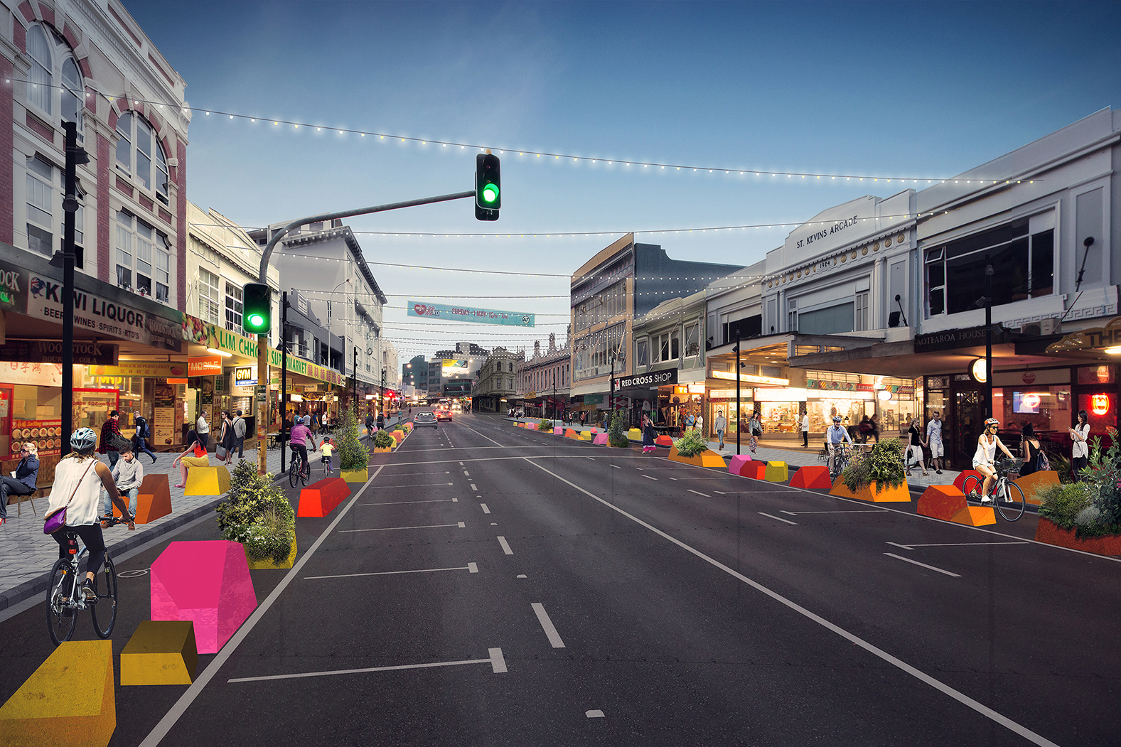
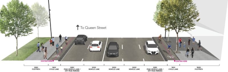
Section 1: Ponsonby Road to Pitt Street Section – The West & Centre
This section of K Road is growing in importance with new apartment blocks going up west of the K Road overbridge. But the design below will extend all the way to Pitt Street, so it also includes a good part of the ‘classic’ K Road. How does it look?
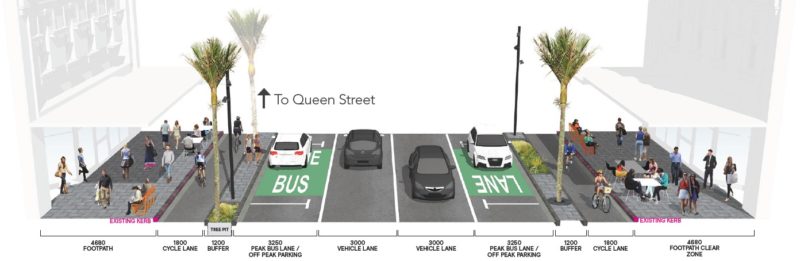
For people on bikes of course, the biggest change is those protected 1.8m cycle lanes! Our only worry is that they’ll need to be widened within ten years or so – because nice grunty protection from cars AND a kerb separation from pedestrians are ideal conditions for the ‘interested but concerned’ potential bike rider, so this will get busy!
For pedestrians, not much seems to change at first glance – but in reality, a lot will. Those grunty, wide cycleway separators will allow AT to move a lot of the existing ‘street furniture’ off the footpath. Goodbye signs, streetlights, landscaping, bike parking – into the buffer strip you go. People on the pavements will have more space, be they of the cafe-sitting or flaneur varieties – almost Queen Street width, at 4.5m. The bike lane buffer strips will also make it easier and quicker for pedestrians to cross the road.
Oh, and there will be kerb build-outs and raised table crossings for pedestrians at side streets. As Jan Gehl says, ‘be sweet’ to pedestrians and people on bikes – and your community will prosper!
The old kerbs, meanwhile, stay where they are – which is cheaper, meaning the design team can roll out a consistent design for the whole of the street and stay within budget.
Peak hour bus lanes are also being added. This means some loss of parking during the day, but it’s back again for evening visitors. And in any case, only 17% of all K Road customers arrive by car (many of them parking in other streets and car parks anyway) – which even now is less than the 21% who arrive by bus!
Bike customer numbers are currently at 3%. What’s the guess we will have that to 6% within a year or so after Great North Road and K Road get their protected lanes?
One other thing to note in this section: AT promises to provide a temporary cycleway link along Pitt Street to Nelson Street, with details available by the end of 2017.

Section 1A: K Road Overbridge – The Gap
This is the bridge that became necessary when the 1950s motorway boom cut a new canyon for cars through the ridgeline, severing the City Centre part of K Road from its more suburban western edge.
The bridge is a bit of a ‘watershed’ at the moment – local lore (and pedestrian counts) tell us that many people simply stop and turn around here, which makes life harder for the shops and businesses west of the bridge. Somehow the sterile environment of the bridge communicates the message ‘You shall not pass.’ And the design constructed for the Rugby World Cup, with the big bus shelters plonked halfway across the footpath, is not universally loved, and may have helped kill off the small market which used to happen here on the wider footpaths.
The bridge is also a major bus stop, and Great North Road / K Road is a very important bus route. But we can’t let the protected bike lanes peter out here, forcing people on bikes out onto the road with buses, or onto the footpath with pedestrians.
Lots of conflicting demands for space. How have AT dealt with that?
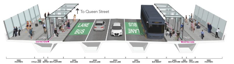
They seem to be going for a half-and-half approach. The bike lanes are narrowed to only 1.5m, so no bike overtaking, unless you go onto the footpath (but maybe just wait until after the bridge). The footpaths are reasonably generous, with more space between the bridge wall and the bus shelters than before.
The travelling bus lane for outbound buses will be retained (because buses stop here longer on average to pick up passengers than on the opposite side). Whereas for citybound buses, bus lane and bus stop are merged. Keeping bus bays separate from bus lanes would undoubtedly a bit better for buses, but would mean narrower footpaths. So this layout seems to us as a pretty acceptable compromise.
PS: In an earlier version, the bike lanes on the bridge were shown as PINK, like Lightpath underneath. We’re disappointed they’re now shown as boring grey. Let’s make ’em pink again!
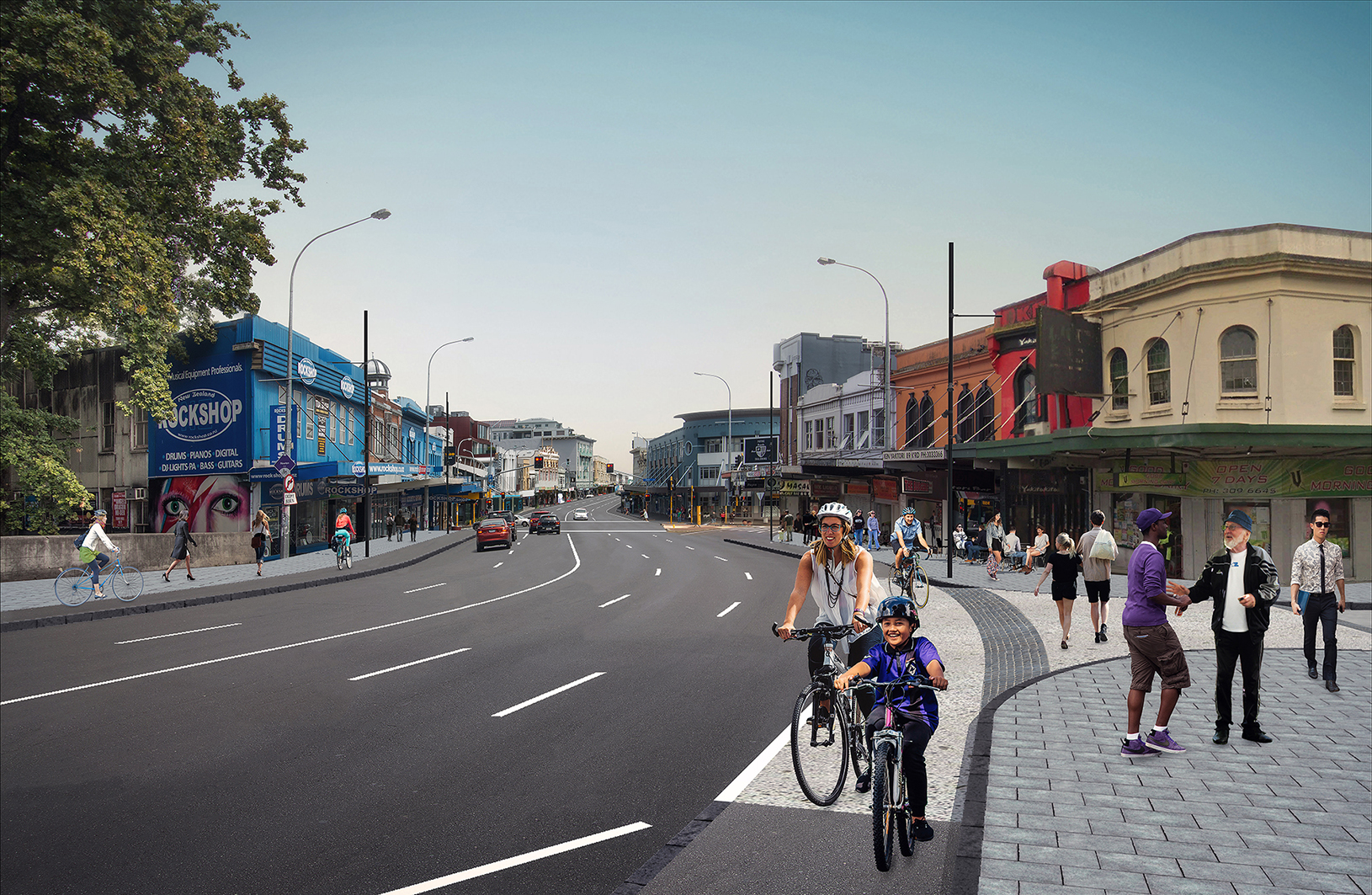
Section 2: Queen Street – Party Zone
Once the train station opens in Mercury Lane, and Light Rail comes to Queen Street, AT predicts that the numbers of pedestrians moving along K Road between these two streets will need massively widened footpaths. But cutting to the chase by removing several traffic lanes several years in advance was always going to be a tough sell.
So AT has settled on a very smart alternative, one we’ve encouraged them for years to start trying – planter boxes, allowing a ‘permanent trial’ (our words).
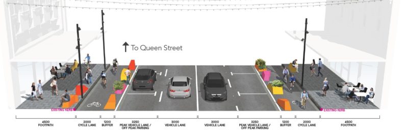
What’s really important for us is that this design ensures we DO get protected bike lanes of high quality (and even a bit extra width) – reassuring, given that at times during the design process, it looked like the bikeway might have to be compromised through this section.
The result is the best of both worlds: a proper bikeway, but also a set-up that can easily be shifted around for a large street party. Or for a future layout with one less traffic lane, which could be changed back if needed. It’s a great way to convince sceptics – much better than traffic modeling. Show, don’t tell!
Section 3: Queen Street to Grafton Bridge – The East
This section grapples with increased traffic volumes heading to the motorway (the Symonds Street motorway off-ramp won’t be removed, even though it was discussed as an early option). Buses aren’t as big a part of the picture, as most will come to and from Pitt Street and skip Section 2 and 3 of the road.
But bike connectivity to Grafton Bridge, pretty much the only eastward link, is absolutely crucial.
So, for space reasons, AT proposes ‘Copenhagen’ raised cycle lanes here – sans the landscaped buffer zone as seen further west. But never fear, the raised kerb will still protect us from moving cars. (But watch out for illegal parking in the bike lane, because some Auckland drivers haven’t gotten the memo, in contrast to the Dutch and Danish people…!).
 The consultation doesn’t yet show what will happen at the Symonds Street / Grafton Bridge intersection. Is it too much to hope that the long-awaited upgrade of the Symonds Street cycleway southwards from K Road – and the removal of that slip lane into K Road – could be part of this project? Probably.
But the case for it only gets stronger with every piece of network falling into place. And speaking of that, here’s the last part of the current proposal:
Section 4: Upper Queen Street – Connecting the Dots
This last short section between K Road and the cycle facilities on Upper Queen Street Bridge is only a hundred metres or so, but for the ‘interested but concerned’, that kind of distance is quite scary, especially when you have to ride a downhill-uphill swoop on asphalt wide enough for six traffic lanes, with cars rushing to beat the lights!
The proposed design will help make sure that all the new goodness on K Road will not stand alone and isolated from Grafton Gully, Lightpath, and the start of the NW cycleway.
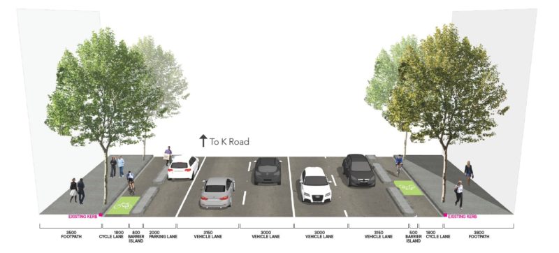
AT is converting some of the massive width here into protected bike lanes – making it a much more suitable entryway into the city centre. Otherwise, not much is changing here.
Still, it’s pretty amazing that the least impressive section of the whole K Road project is one that adds protected cycle lanes to both sides of a street. Way to recalibrate ‘minimum quality’, AT. Well done.
In Summary: Bring the Awesome!
This is a really strong, spectacular, and encouraging piece of design, one to be proud of – and one to support wholeheartedly. Add your feedback here – consultation is open until 20 November 2016.
AT is holding info sessions on Wednesday 26 October at:
- St Kevins Arcade (183 K Road), 11am-2pm
- Methodist Church (78 Pitt Street), 5pm-8pm


