Feedback is now invited on the cycling improvements through Grey Lynn, Arch Hill, and Westmere, with consultation now extended until midnight Friday 21st October. HERE’S THE LIGHTNING-QUICK WAY TO MAKE YOUR VOICE COUNT!
As you can see from the map below (click to enlarge), this is a vital extension beyond the CBD, designed after the extensive feedback exercise earlier in the year. It features new dedicated bike lanes along the ridge route of Great North Road and reaching well into Westmere and Grey Lynn, where they’ll complement enhanced greenways. All projects are scheduled to be completed by 2018.
With substantial benefits for pedestrians and public transport, and slower traffic speeds, these are really exciting steps towards a bikeable Auckland!
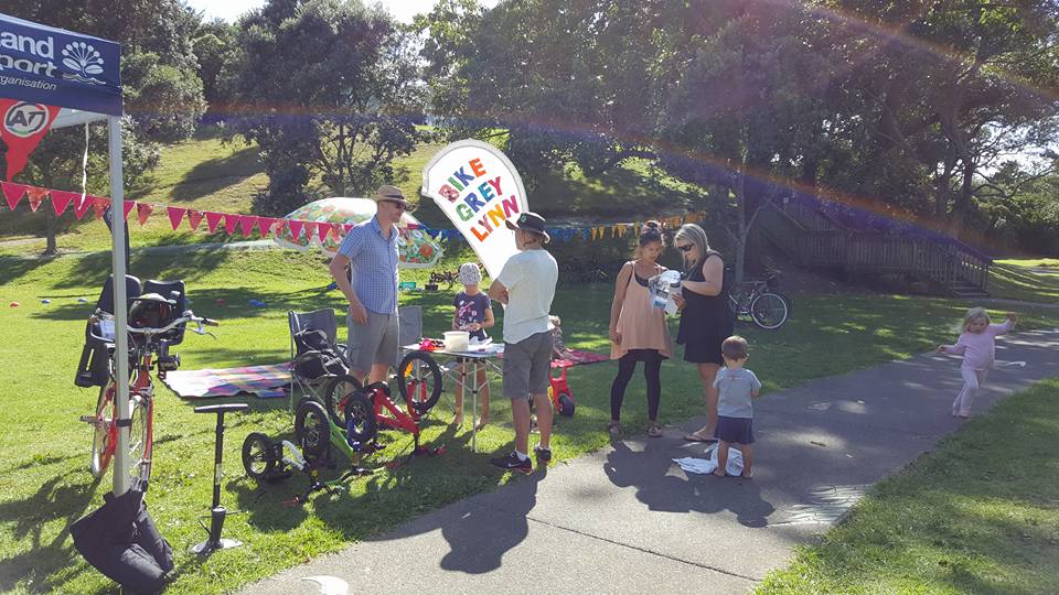
AT will be hosting public information sessions at the Grey Lynn Farmers’ Market on Sunday 25 September and 2 October 2016, from 9am to 12.30pm.
For ease of feedback, the consultation is divided into four sections, working west to east.We have some specific thoughts about each section of the route, which we’ll cover in separate posts. For now, we’re eager to hear your first reactions. Read on…


Route 1: Surrey Crescent to Garnet Road
This section embraces two schools (Westmere and Grey Lynn) as well as shops, cafes, and a whole lot of residents who will now be within a short, safe bike trip of the city.
The Meola Rd roundabout and the Grey Lynn shops aren’t included this time, but will be addressed as separate projects – the roundabout later this year, and the shops in the next funding period (2019-2021)
That said, the really big win here is separated cycleways along the whole route, along with improvements for pedestrians, upgraded safety at intersections, and the possibility of ‘floating’ bus stops – or, bus stop bypasses for people on bikes.
There are two design options here, and AT would like feedback on both with a view to refining the design. At first glance, the main difference is how much on-street parking is removed. But how do they compare for improving things for people of all ages on bikes?

Option A: mixed on/off-road bike lanes (see detailed plans)
Heading towards Grey Lynn shops
- A 1.5m-1.8m wide on-road cycle lane, separated from general traffic by a row of parked cars and some physical separators.
Heading towards Meola Road, a mixture of:
- A 1.5m – 1.8m wide on-road cycle lane, separated from general traffic by a row of parked cars and some physical separators (from Grey Lynn shops along Surrey Crescent to the bend at Richmond Rd)
- A 1.6m wide raised off-road cycle path on the grass berm, separated from the footpath by a small grass buffer (from Richmond Rd to the Meola Rd roundabout, with on road options across side streets).
This option would reduce on-street parking by approximately 10-15% (40 spaces over 2km).

Option B: on road, both directions (see detailed plans)
- A 1.5m – 1.8m wide on-road cycle lane, separated from general traffic by a row of parked cars and some physical separators.
To allow protected on-road lanes along the full route in both directions, this option would reduce on-street parking by approximately 35-40% (approximately 120 spots over 2km), and will involve the removal of the painted median at some points.

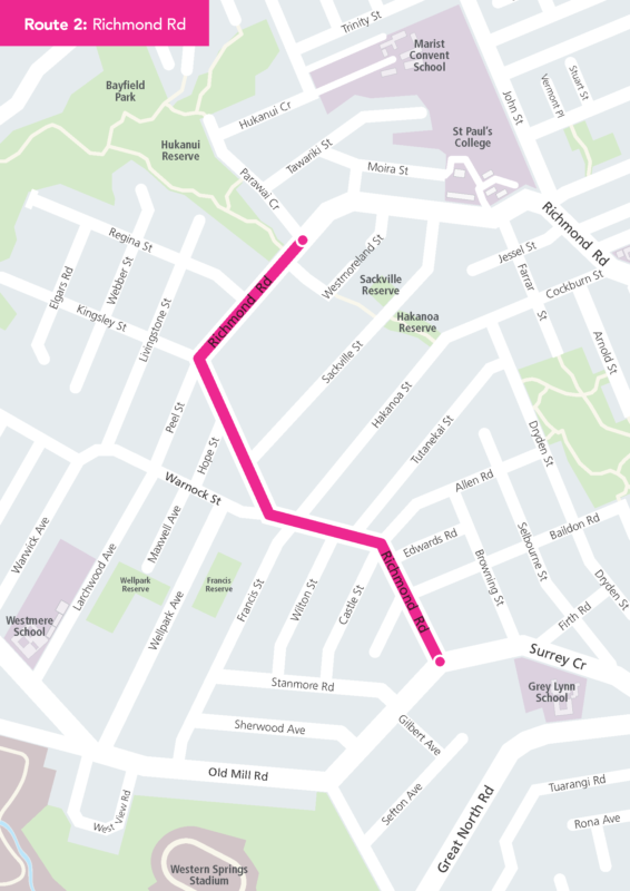
Route 2: Richmond Rd
Richmond Rd proved very popular in the previous consultation round for walking and cycling improvements; no surprise as it is home to several major shopping precincts, and intersects with an existing greenway. Among the improvements proposed for this section (see detailed plans):
- 1.5-1.8m wide cycle lanes, mostly on-road and separated from vehicles by a 0.5m painted buffer.
- Short sections of raised, off-road cycle paths on the berm at the new roundabout intersection at Peel Street, Richmond Road and Kingsley Street.
- Gateway treatments for both ends of the West Lynn shopping precinct (‘slow’ road markings with red surfacing) and outside 252 Richmond Road
- Raised speed tables in two locations in West Lynn shopping centre, including raising the existing pedestrian crossing near Francis Street/ Hakanoa Street.
- New high-friction surfacing to improve vehicle slowing ability on the approach to the Countdown pedestrian crossing
- Reconfiguration of parking in the West Lynn shopping centre (reduced by six spots)
- Minimal loss of on-street parking along the rest of the route (approximately 10 spaces)

Route 3: Greenways Route
Canny riders in the area will already be familiar with great chunks of this route – it’s popular among families as a link between Grey Lynn Park and Cox’s Bay Reserve. The improvements to this route will formalise and upgrade the links already in use, making the most of recently widened paths through the parks (thanks, Waitemata Local Board!). See plans for details; key features include:
- A new signalised pedestrian crossing on Richmond Road (east of Westmoreland Street).
- Footpath widening along Westmoreland Street to create a 3m-wide shared walking and cycling path, leading across a raised table into the alleyway connection (near Farro).
- More raised tables and speed humps along the route and some surrounding streets (Westmoreland Street, Sackville Street, Hakanoa Street, Cockburn Street, Dryden Street, Grosvenor Street).
- New traffic lights at the intersection of Williamson Avenue and Grosvenor Street (with cycle stop boxes on each approach).
- Four-way ‘stop’ controls at the intersections of Crummer Road and Grosvenor Street, Baildon Road and Dryden Street, and Prime Road and Dryden Street.
- Three-way ‘stop’ controls at the intersections of Allen Road and Dryden Street, and Firth Road and Dryden Street.
- Existing parking on Grosvenor Street to be changed to reverse-in angled parking.
- Removal of a few parking spots (up to 10 spaces) along Dryden Street to accommodate bike ramps so people on bikes can access paths.

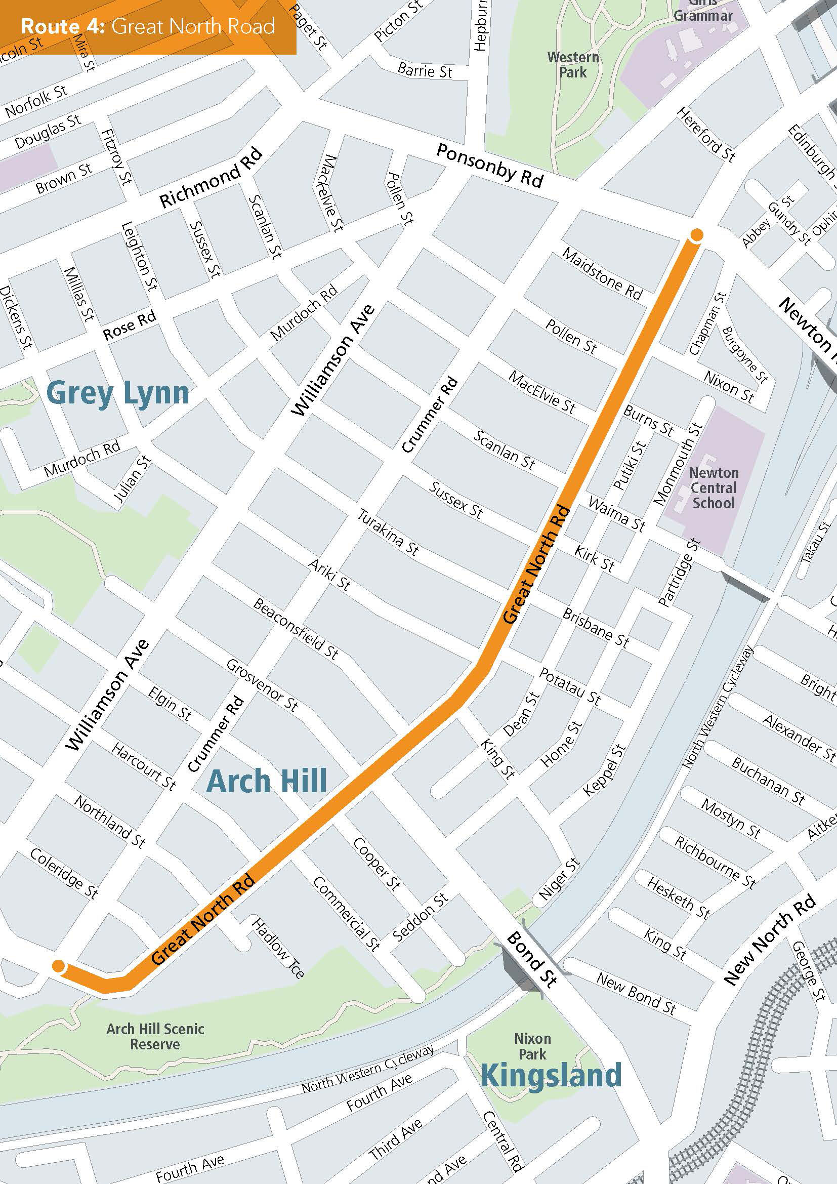
Route 4: Great North Road
This changes everything, as you can see from the project page and the detailed plans! As well as the installation of protected bike lanes, there’s a big bus-stop shuffle, improvements for pedestrians, and safer intersections.
Of particular interest to the bike community:
- 1.5m-wide cycle lane, on-road for nearly the entire length of the route, on both sides of the road, inside the bus lane – separated from the bus lane by a 0.5m physical or painted buffer.
- Due to lack of space on the road, a small section of raised off-road cycle path on the existing concrete berm (past the library) heading towards Grey Lynn shops, between Coleridge Street and Crummer Road.
- Narrowing of the central median to 1.7-2.2m along the length of the route.
A few non bike-specific changes of note:
- A new large loading zone near Nixon Street to accommodate car transport vehicles.
- Some reduction of on-street parking (approximately 13% of currently available parking; 23 spaces).
- Removal of one non-native, 3m high tree near Ariki Street to accommodate a relocated bus stop. (A replacement tree will be planted elsewhere on the route.)
And because we know you love buses, here is the bus news:
- City-bound bus lane operating hours extended in morning peak from 7-9am to 7-10am.
- West-bound bus lane operating hours extended in afternoon peak from 4-6pm to 4-7pm.
- Bus lanes physically extended at all the intersections to reduce bus interaction with general traffic and reduce journey times.
- Bus stop improvements (where space permits) to allow cyclists to navigate past the bus stops safely and without interruption – find out about the intended ‘floating’ bus stop design.
- A reduction from 14 to 10 bus stops along the route to improve bus stop spacing and efficiency of bus services.
For now, the Karangahape Rd intersection and, as previously noted, the Grey Lynn shops on Great North Road, will remain as-is. Here’s AT’s statement on that:
Intersection of Ponsonby Road, Great North Road and Karangahape Road
This intersection is under investigation and will be improved as part of the upcoming Karangahape Road Streetscape Improvements Project.This will ensure this intersection is safe and convenient for people on bikes, as well as pedestrians and motorists.
The route through Grey Lynn shops
The Grey Lynn shopping centre section of the cycling network is being treated as a separate project to this proposal. There are several factors to consider when designing a connection through this area and there is no easy solution. When investigating possible options we will carefully consider the needs of people and groups with an interest in this section of Great North Road (such as people on bikes, businesses, vehicle users and bus users).
It’s a little bit like this classic cartoon. But the bulk of the project is happening soon. And we’ll get there eventually!