

Over recent years, there’s been a lot of chat about building ‘the right kind of cycleways’ for Auckland. Should we focus on primary routes (on big arterials, along motorways and railway lines)? Or more on ‘Greenways’ – which is to say, routes along slower, quieter streets and through ‘open space’ (that’s Council-speak for parks and reserves)?
Fans of Greenways make the case that they’re wonderfully laid-back routes, where beginners and families with kids can cycle without the constant stress of traffic. Skeptics reckon this is ‘taking the easy road’, by investing only in uncontroversial and/or roundabout routes that aren’t much use for actual transport cycling, are often sub-standard, and (in the case of paths through parks) often put people on bikes in conflict with pedestrians.
There’s some truth on both sides of this argument. Meanwhile, Auckland Council and Auckland Transport have identified a need to lift the game when Local Boards design and build Greenways routes, to ensure they’re up to standard, allow for relaxed riding, and also form a useful part of the larger transport network.
We can now finally share their work in this sphere, which has been cooking away in the background for a while now: the new Local Path Design Guide (lean version – full version to come).
What does the Local Path Design Guide do? Let us allow it to summarise itself:
Sounds exciting – so let’s have a look at some of the sections.
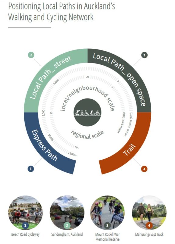
First off, what is a Local Path – and what isn’t? Here, they have provided a handy diagram. As you can see, there are two categories of Local Path – those on streets, and those in open space – which sit between ‘Express Paths’ (think your protected cycleways or NW Cycleway-type paths) and ‘Trails’ (think bush tracks and NZ Cycle Trails).
So now we know where Local Paths sit, what are the design principles? Again, let’s go straight to the source, which tells us the paths should be Safe, Connected, Accessible & Comfortable, and Enabling:
Then we come to the two really key things that will affect the experience of on-road Local Paths. How many cars will share a Local Path route, and how fast will they go?
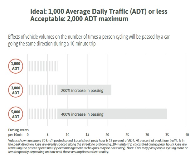
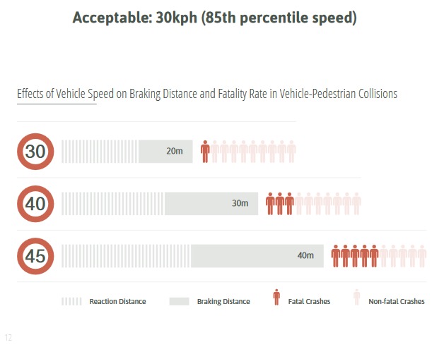
Wow, that’s exactly what we have been pushing for as well! Yes, it will be challenging to overcome the traditional road design to actually ACHIEVE those 30 km/h speeds – but it’s great that our city council is now officially backing this principle for such cycle routes. Bring it on – or rather, ‘slow it down’!
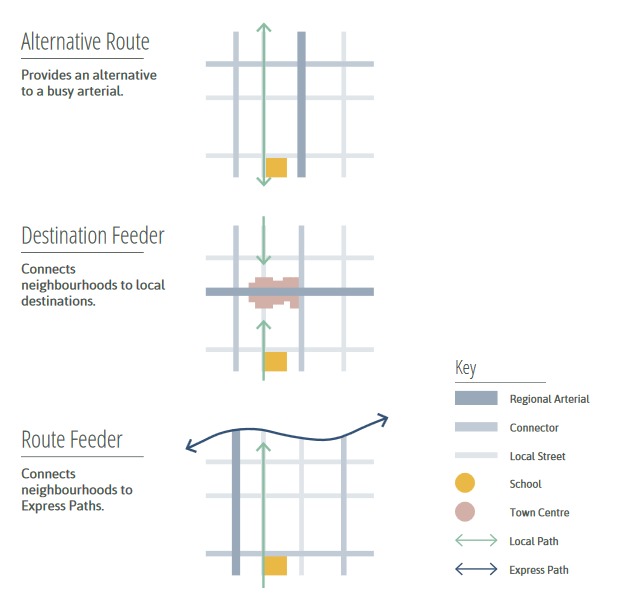
Where will the Local Paths be located? Again, check out the great diagram showing the concept:
Next comes a useful (and not too technical) section which explains how to review your local ‘hood – or your Local Board area – to discover the most promising routes. This way, the cream rises to the top, and new ‘Local Paths’ ideally work both for the family outing on Sunday as well as the quick milk run to the shops.
There’s also a neat step-by-step tactical urbanism guide for getting things up and running sooner rather than later, as shown in the example below:
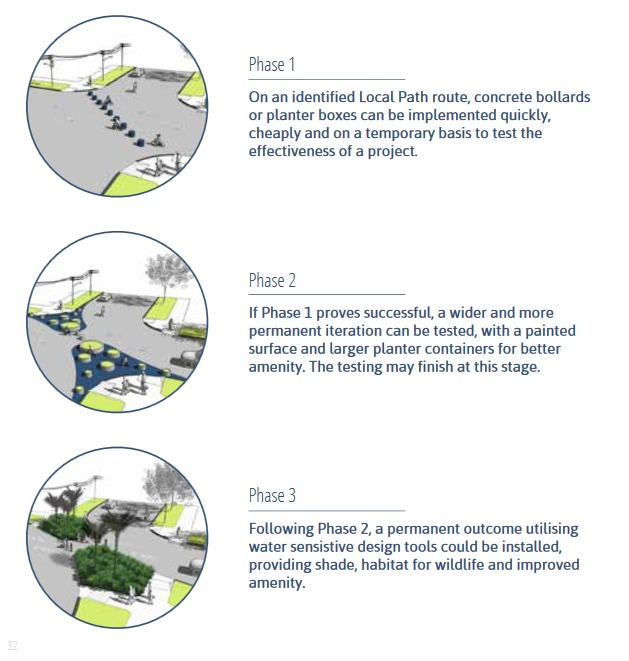
Can we all say ‘yes please, by tomorrow, please’ to that?
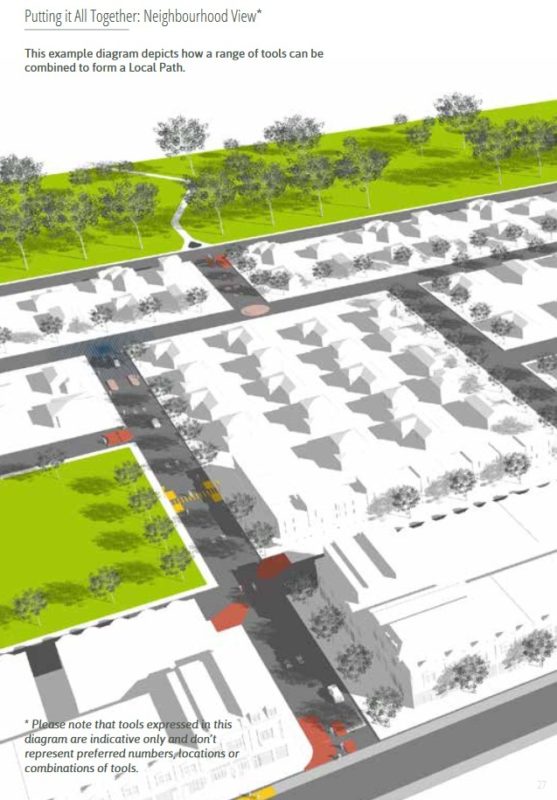
And, just as a step-by-step approach can help figure out what works in a particular spot, a bunch of approaches can be knitted together to create a Local Path through a neighbourhood.
And finally, we get to the ‘how to’ part, the Local Path Toolkit. This is very much where the eye candy is – and where the magic happens, for those of us who are really keen on better bike infrastructure that’s more than ‘just’ protected lanes and ‘cycle superhighways’. We reckon our Bike Burb groups in particular will rejoice at finally having an official council document that supports the kind of local improvements they’ve been seeking for years.
So, what kind of things are in the Local Path Toolkit? Good things.
Like tools to reduce traffic volumes:
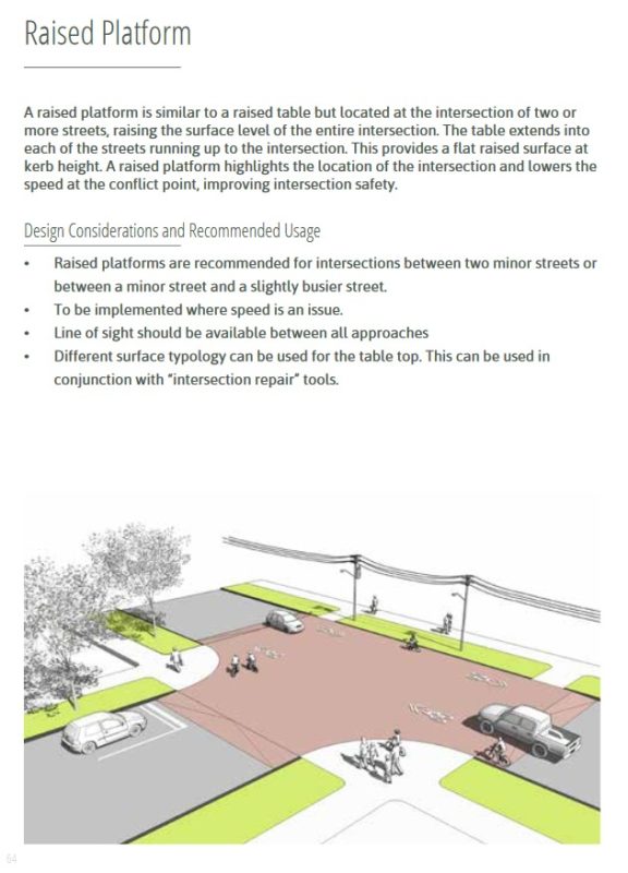
Or tools to reduce speeds:
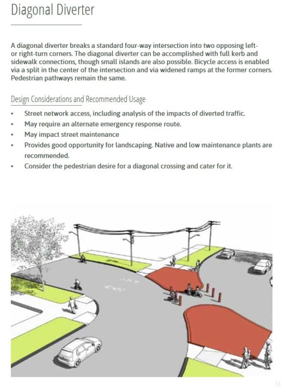
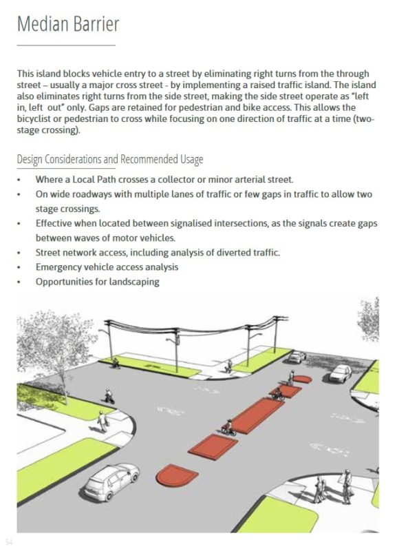
Or tools for crossing (main) streets:
So there it is, the new Local Path Design Guide.
There are many more sections and examples, bringing our Auckland standards so much closer to best practice. The tree-lovers among you will be thrilled by the section on ‘how green should a greenway be’, for example. By all means, dig in and tell us what you like.
Last question – and it’s a good one: what is the Design Guide’s official status? When finalized – and, in due course, when ATCOP (the current rule set) and the Auckland Design Manual are updated, it will become a core part of the new design standard, rather than a standalone document like it is now.
So, have a good read. It’s a very user-friendly document; kudos to Resilio Studio and MR Cagney for their beautiful work. Find the bits that might work for your ‘hood. Shout the good stuff from the rooftops, discuss with your neighbours and freshly elected Local Boards – and maybe even use it to remind a traffic engineer that things have, indeed, progressed.


