
In a week when we’ve been thinking about how kids get to school, and the importance to kids of freedom on wheels, here’s a guest post by Nicholas Lee (cross-posted at Greater Auckland). Read on for a vision of a bikeable neighbourhood that will let more children ride to school and beyond, and open up the area for longer local trips.
I began commuting by e-bike, from Onehunga to Wiri, last year, around the time my eight-year-old daughter started cycling or scooting to school with a group of neighbourhood friends, children aged 8 to 10, without adult supervision.
For me, cycling is a personal action towards reducing greenhouse emissions. For my daughter and her friends, cycling/scooting is just fun. When my son started school last year, we could not leave the five-year-old in the care of middle-schoolers. So I would occasionally join them and scoot or cycle with all the children. The distracted younger child could not be trusted at this stage to look both ways when crossing the street, but in time, with development and routine he will be able to join his sister.
As their competence and confidence grow, we hope they will expand their range. This means: cycling to the pool, soccer practice, piano teacher, friends’ houses, and then intermediate and high school, on their own. They’d never need – and they’d certainly never want – to be driven around. They’ll become used to cycling in a way that some controversial pundits associate with a bygone era.
Yet while the route from our neighbourhood to the school is ‘relatively’ safe, this is not the case for most of Onehunga. I have lived in Onehunga for over a decade and worked here much longer. I know these streets well as a driver and a pedestrian; and I know these streets as a parent with a pram, and accompanying walking or cycling children. These experiences have made me very aware of the problems and dangers caused by the poor street design in Onehunga.
There is an overwhelming agreement that the biggest hurdle to increasing cycle usage in Auckland is not rain or hills, but a lack of protected and connected networks. Auckland is three years behind schedule, and no new cycleway work has started in the last year.
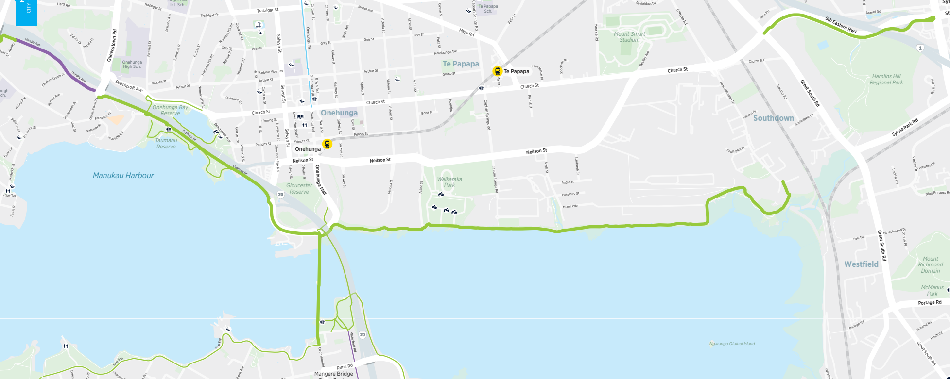
There are existing bike networks around Onehunga, but they are at the edges and of limited benefit to the community or our children.
In the absence of committed central action, what do we do? My answer is to lobby for cycling infrastructure on the neighbourhood level, the streets we know, in the expectation that these will then, in a not-too-distant future, connect into a larger network.
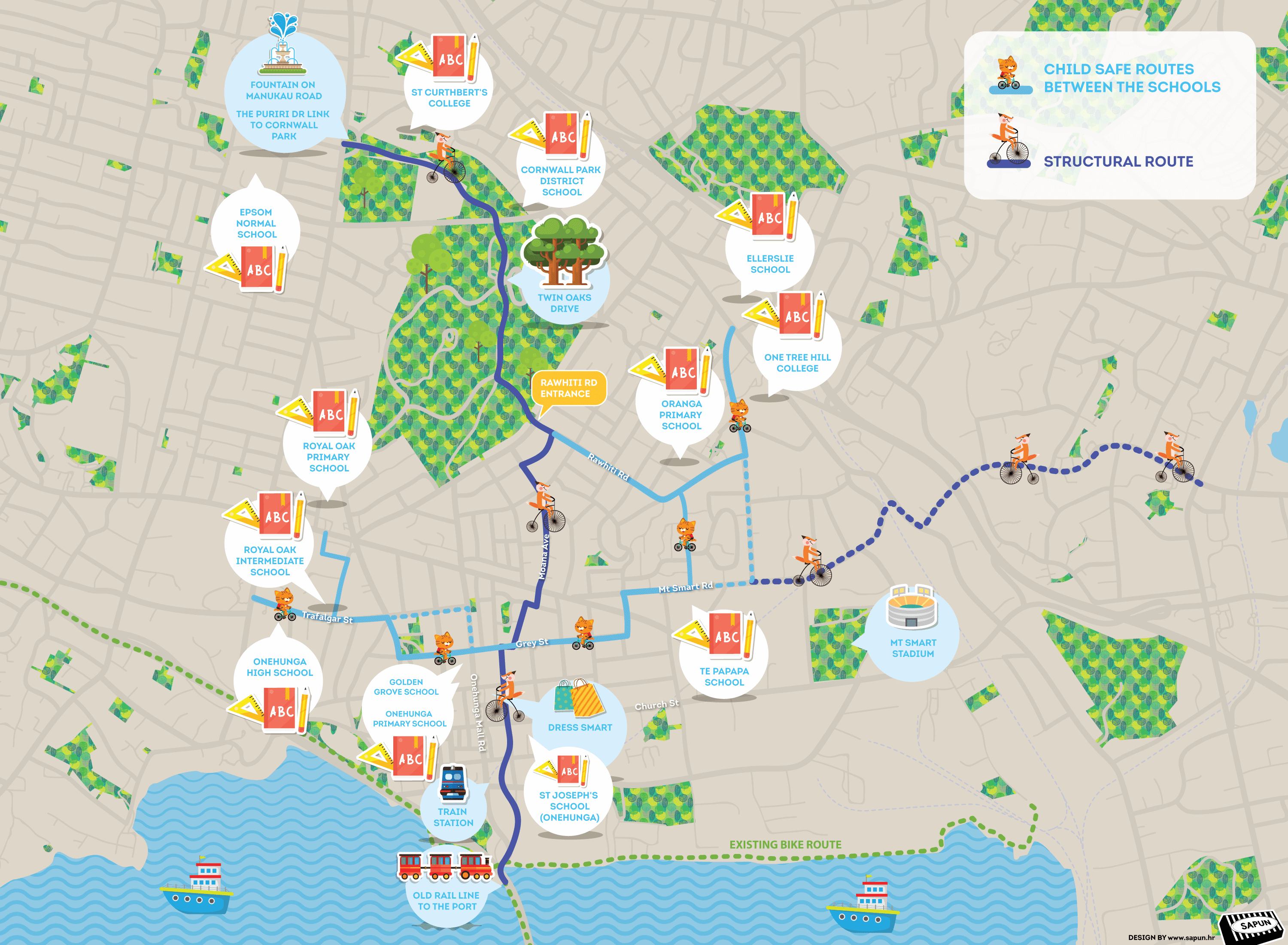
The following is an introduction to a plan for designated cycle routes that I’ve been developing for around Onehunga, as visualized in the map below. It has two main parts:
- Child safe routes (east-west) between the schools
- Structural route (north-south) – to integrate in future the Onehunga ‘spine’ with the direct route from the City, connecting through Mangere Bridge to South Auckland.
Below, I discuss the reasons I chose each particular route, and then outline possible problems and challenges. Comments and criticisms are very welcome!
The plan has been presented to the planners in charge of Transform Onehunga at Panuku, several local groups, and local bike enthusiasts, including Bike Onehunga. I am grateful to everyone who has commented on the draft of this post or who have taken the time to discuss these ideas. Many of these comments have been integrated into the map, and all of them have changed my thinking for the better.
Above all, this post is a starting point for a public discussion. The next step may be a kanohi ki te kanohi (face-to-face) meeting, perhaps in The 312 Hub or Onehunga Library. If you’re interested, please drop me a line.
Child-safe routes (east-west)
It has been indicated that a government target for the coming year is creating better access for active modes around schools. Child-safe protected cycle paths are a key element to achieve this goal.
Between Onehunga High School and One Tree Hill College there are seven primary schools and one intermediate. The best route to cover and connect all of these schools runs along Trafalgar Street, Grey Street and Mt Smart Road. It is a relatively level route and all roads are wide enough to allow a protected path to be created.
Challenges/problems: There are some challenges such as the afternoon peak traffic on Grey St as well as the morning and afternoon peak traffic on Mt Smart Road. The area around Jellicoe Park struggles with many vehicles visiting the pool and gym. A route through the park would be safer, but includes a slope; the route around the park conflicts with traffic and parking.
The precise route around Waitangi Road and Oranga Ave may depend on the HLC redevelopment plans.
Structural route (north-south)
The structural route is based on the following elements:
- The existing 30 kph zone from Manukau Road, though Puriri Dr and Cornwall Park to Rawhiti Road.
- Moana Ave being wide enough to add a protected cycle way.
- Avoiding Manukau Road and the Royal Oak roundabout.
- HCNZ/HLC redevelopment of the Jordan North site allows improvement to the pedestrian connection to Wade Ave/Grey St.

- Avoiding Onehunga Mall Road due to the challenges of existing stakeholders (businesses) and removing on-street parking. Plus the narrow road width at the upper end.
- The Galway St exit to Arthur St which should be closed to vehicles. This is also needed to improve safety.
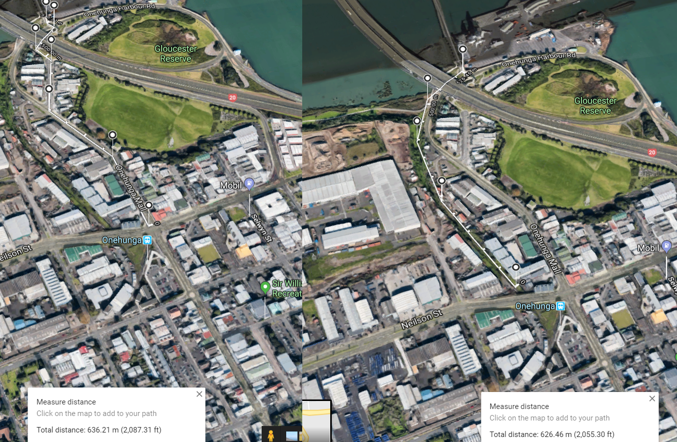
- The old railway corridor from the train station to the port which provides a very safe way to separate cyclists and pedestrians from the heavy traffic around Neilson St and the lower end of Onehunga Mall Rd. Especially the difficult right turn (see video) towards the Mangere Bridge pedestrian/cycle crossing.
Some additional elements that need to be considered:
- Upgrading the Cornwall Park Rawhiti Road exit to allow after-hours access by cyclists.
- Lighting along Twin Oaks Drive.
- Closing the Twin Oaks Drive section to vehicles – bollards to prevent though-traffic.
- Crossings (new or upgraded) at various locations – Mt Smart Road, Grey St, Neilson St.
- Rearrangement of the traffic flow and intersections south of Dressmart on Galway St.
- Closing the bottom end of Rawhiti Rd and turning the area into a mini town centre.
- Applying the principles of filtered permeability.
- Upgrading the street network into the 21st century.
If you wish to contact me directly about these plans, please do via Twitter or email. (And especially if you’re local, you can also slide on over and join the conversation at Bike Onehunga on Facebook).
— Nicholas Lee


